Country:
 USA
USARegion:
City:
Latitude and Longitude:
Time Zone:
Postal Code:
IP information under different IP Channel
ip-api
Country
Region
City
ASN
Time Zone
ISP
Blacklist
Proxy
Latitude
Longitude
Postal
Route
IPinfo
Country
Region
City
ASN
Time Zone
ISP
Blacklist
Proxy
Latitude
Longitude
Postal
Route
MaxMind
Country
Region
City
ASN
Time Zone
ISP
Blacklist
Proxy
Latitude
Longitude
Postal
Route
Luminati
Country
USRegion
mo
City
rolla
ASN
Time Zone
America/Chicago
ISP
MST
Latitude
Longitude
Postal
db-ip
Country
Region
City
ASN
Time Zone
ISP
Blacklist
Proxy
Latitude
Longitude
Postal
Route
ipdata
Country
Region
City
ASN
Time Zone
ISP
Blacklist
Proxy
Latitude
Longitude
Postal
Route
Popular places and events near this IP address

Rolla, Missouri
City in Missouri, United States
Distance: Approx. 1601 meters
Latitude and longitude: 37.94583333,-91.76083333
Rolla () is a city in, and the county seat of, Phelps County, Missouri, United States. Its population in the 2020 United States Census was 19,943. It is approximately midway between St.
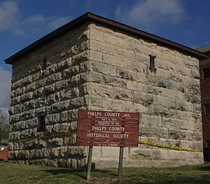
Phelps County Jail
United States historic place
Distance: Approx. 1097 meters
Latitude and longitude: 37.94584722,-91.77420833
Phelps County Jail is a historic jail located on Park Street between Second and Third Streets, Rolla, Missouri, was built in 1860 for $3,000. The jail was operated by Phelps County from 1860 to 1912. Union forces, which took over the town in 1861, used the jail for both military and civilian prisoners during the American Civil War.
Rolla High School
Public school in Rolla, Missouri, United States
Distance: Approx. 889 meters
Latitude and longitude: 37.9506,-91.7663
Rolla Senior High School is a public secondary school located in Rolla, Missouri, United States. The school's mascot is the Bulldog with the colors of maroon and silver (formerly maroon, gray, and gold). The high school offers many clubs, including Student Council (StuCo) as part of Missouri Associations of Student Councils, Key Club, Octagon Club, DECA, FBLA, FFA, FCCLA, TSA, Math Club, Chess Club, Improvisation Club, Spanish Club, German Club, French Club, Latin Club, and the new addition Link Crew and HOSA Future Health Professionals.

National Bank of Rolla Building
United States historic place
Distance: Approx. 715 meters
Latitude and longitude: 37.94972222,-91.77111111
The National Bank of Rolla Building was opened in March 1931 at 8th and Pine Streets in Rolla, Missouri, midway between St. Louis and Springfield. Because of its architectural character and its importance in the life of the city and history of U.S. Route 66, the building was added to the National Register of Historic Places in 2001.
Missouri University of Science and Technology Nuclear Reactor
Open pool nuclear reactor
Distance: Approx. 192 meters
Latitude and longitude: 37.95454,-91.77248
The Missouri University of Science and Technology Nuclear Reactor (MSTR or Missouri S&TR) is a swimming pool type nuclear reactor operated by the Missouri University of Science and Technology (Missouri S&T). It first achieved criticality in 1961, making it the first operational nuclear reactor in the state of Missouri. Missouri S&T operates this reactor for training, education, and research purposes.
Phelps County Courthouse (Missouri)
United States historic place
Distance: Approx. 1104 meters
Latitude and longitude: 37.94583333,-91.77277778
Phelps County Courthouse is a historic courthouse located in Rolla, Phelps County, Missouri. The original section was built between 1860 and 1868 and is a two-story, Greek Revival style brick building. The original building measures approximately 45 feet by 65 feet.

Missouri University of Science and Technology
Public university in Rolla, Missouri, US
Distance: Approx. 54 meters
Latitude and longitude: 37.955544,-91.773513
Missouri University of Science and Technology (Missouri S&T or S&T) is a public research university in Rolla, Missouri. It is a member institution of the University of Missouri System. Most of its 6,456 students (2023) study engineering, business, sciences, and mathematics.
KJTR-LP
Radio station in Rolla, Missouri
Distance: Approx. 2043 meters
Latitude and longitude: 37.95527778,-91.75083333
KJTR-LP (101.7 FM) is a radio station licensed to Rolla, Missouri, United States. The station is currently owned by Rolla Chinese Christian Association.
Fort Dette
Distance: Approx. 256 meters
Latitude and longitude: 37.953635,-91.772826
Fort Dette, or as it was sometimes known, Star Fort, was a double-deck fortification built in a Greek Cross or "+" configuration in Rolla, Missouri. A blockhouse built in East Rolla, it was named Fort Dette, after Captain John F. W. Dette, an officer who supervised most of its construction. It was arranged for emplacement of artillery on the ends of both decks, it had a light field piece on the bottom deck, and a larger caliber gun, probably a 32- or 24- pounder, on the deck above.
Frisco Lake
Lake in Phelps County, Missouri
Distance: Approx. 616 meters
Latitude and longitude: 37.9553193,-91.7671024
Frisco Lake is a small lake in Rolla, Phelps County in the U.S. state of Missouri. Frisco Lake was both named for and owned by the Frisco Railroad.
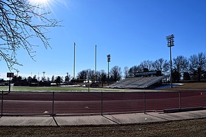
Allgood–Bailey Stadium
Stadium in Rolla, Missouri
Distance: Approx. 856 meters
Latitude and longitude: 37.950198,-91.780909
Allgood–Bailey Stadium is an outdoor stadium on the campus of the Missouri University of Science and Technology in Rolla, Missouri. The stadium has a capacity of 8,000 and hosts Missouri S&T Miners football games and track and field competitions. It opened in 1967 and was known as Jackling Field until 2000, when it was renamed after football and basketball coach Dewey Allgood and benefactor Keith Bailey.
Rolla Ranger Station Historic District
Historic district in Missouri, United States
Distance: Approx. 1921 meters
Latitude and longitude: 37.94361111,-91.78972222
Rolla Ranger Station Historic District is a historic ranger station and national historic district located at Mark Twain National Forest near Rolla, Phelps County, Missouri. The station includes five frame and limestone buildings constructed by the Civilian Conservation Corps (CCC) during 1937 and 1938. They were built under the supervision of a Works Progress Administration (WPA) project.
Weather in this IP's area
mist
21 Celsius
22 Celsius
20 Celsius
22 Celsius
1017 hPa
96 %
1017 hPa
977 hPa
6437 meters
2.06 m/s
100 degree
06:06:19
20:20:38