Country:
 Kuwait
Region:
City:
Latitude and Longitude:
Time Zone:
Postal Code:
IP information under different IP Channel
ip-api
Country
Region
City
ASN
Time Zone
ISP
Blacklist
Proxy
Latitude
Longitude
Postal
Route
IPinfo
Country
Region
City
ASN
Time Zone
ISP
Blacklist
Proxy
Latitude
Longitude
Postal
Route
MaxMind
Country
Region
City
ASN
Time Zone
ISP
Blacklist
Proxy
Latitude
Longitude
Postal
Route
Luminati
Country
KWRegion
ku
City
kuwaitcity
ASN
Time Zone
Asia/Kuwait
ISP
Kuwait University
Latitude
Longitude
Postal
db-ip
Country
Region
City
ASN
Time Zone
ISP
Blacklist
Proxy
Latitude
Longitude
Postal
Route
ipdata
Country
Region
City
ASN
Time Zone
ISP
Blacklist
Proxy
Latitude
Longitude
Postal
Route
Popular places and events near this IP address

Kuwait City
Capital and largest city of Kuwait
Distance: Approx. 4 meters
Latitude and longitude: 29.36972222,47.97833333
Kuwait City (Arabic: مدينة الكويت) is the capital and largest city of Kuwait. Located at the heart of the country on the south shore of Kuwait Bay on the Persian Gulf, it is the political, cultural and economic centre of the emirate, containing Kuwait's Seif Palace, government offices, and the headquarters of most Kuwaiti corporations and banks. It is one of the hottest cities in summer on earth, with average summer high temperatures over 45 °C (113 °F) for three months of the year.
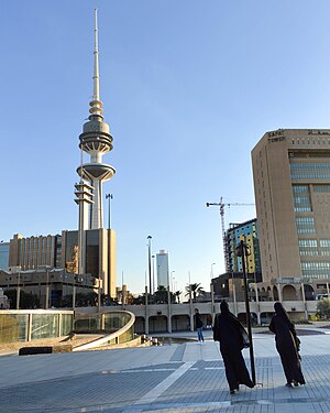
Liberation Tower (Kuwait)
Distance: Approx. 361 meters
Latitude and longitude: 29.36827778,47.97495278
The Liberation Tower is a 372-meter-high or 1,220 feet tall telecommunications tower in Kuwait City, Kuwait. It is the second-tallest structure in the country and the 39th tallest building in the world. The tower is not publicly accessible to tourists.
Boursa Kuwait
Distance: Approx. 931 meters
Latitude and longitude: 29.37777778,47.97583333
Boursa Kuwait Securities Co., is the private-sector corporate owner and operator of the Kuwait Stock Exchange (KSE), the national stock market of Kuwait.
Safat
Historical commercial square in Kuwait City, Kuwait
Distance: Approx. 507 meters
Latitude and longitude: 29.3716104,47.9735559
Safat Square (Arabic: ساحة الصفاة Sahat al Safat) is a major historical commercial square in Kuwait City, Kuwait.
Kuwait Investment Authority
Sovereign wealth fund of Kuwait
Distance: Approx. 606 meters
Latitude and longitude: 29.36444444,47.97666667
The Kuwait Investment Authority (KIA) is the Middle East's oldest sovereign wealth fund, managing the state’s reserve and the state’s future generation fund (FGF). Founded in 1953, the KIA is the world's oldest sovereign wealth fund. As of October 2023, it is the world's 5th largest sovereign wealth fund with US$803 billion in assets under management.
Mirgab
Area in Capital Governorate, Kuwait
Distance: Approx. 462 meters
Latitude and longitude: 29.36555556,47.97805556
Al Murqab (Arabic: المرقاب) is an area in Kuwait City, Kuwait. It is located in the Capital Governorate 8 miles (13 km) from Kuwait International Airport. Nearby areas include As Salihiyah (0.5 nmi or 1 km), Jibla (0.6 nmi or 1.1 km), Al Kuwayt (0.2 nmi or 0.4 km), Umm Siddah (0.8 nmi or 1.5 km) and Al Mansuriyah (0.6 nmi or 1.1 km).
Fajhan Hilal Al-Mutairi Court
Distance: Approx. 0 meters
Latitude and longitude: 29.3697,47.9783
Fajhan Hilal Al-Mutairi Court is an indoor sporting arena located in Kuwait City, Kuwait. The capacity of the arena is 5,000 spectators. It hosts indoor sporting events such as basketball and hosts the home matches of Al Qadisiya Kuwait.
InterContinental Kuwait Downtown
Distance: Approx. 24 meters
Latitude and longitude: 29.369607,47.978072
The InterContinental Kuwait Downtown was a planned InterContinental hotel in Kuwait City, Kuwait. Announced in 2012, it was scheduled for completion in early 2015. It was to be located in close proximity to the government and business centre of the city.
Kuwait Chamber of Commerce and Industry
Institution for business and industry in Kuwait
Distance: Approx. 371 meters
Latitude and longitude: 29.37166667,47.98138889
Kuwait Chamber of Commerce and Industry (KCCI) (Arabic: غرفة تجارة وصناعة الكويت) is a non-government institution representing business establishments in Kuwait. The Chamber acts on the behalf of, represents and lobbies for the interests of businesspersons and industrialists in Kuwait.
Timeline of Kuwait City
Distance: Approx. 4 meters
Latitude and longitude: 29.369722,47.978333
The following is a timeline of the history of Kuwait City, Al Asimah Governorate, Kuwait, and its metro surroundings.

2015 Kuwait mosque bombing
Bombing at a Shia mosque in Kuwait on 26 June 2015
Distance: Approx. 788 meters
Latitude and longitude: 29.3766007,47.97647412
A suicide bombing took place on 26 June 2015 at a Shia mosque in Kuwait. The Islamic State of Iraq and the Levant claimed responsibility for the attack. Sabah al-Sabah, the Emir at the time, arrived at the location of the incident after a short period of time.
Jibla, Kuwait
District in Capital Governorate, Kuwait
Distance: Approx. 689 meters
Latitude and longitude: 29.37111111,47.97138889
Jibla (Kuwaiti Arabic: جِبْلَة, romanized: Jibla, from Qibla قِبْلَة) is a historic area of Kuwait City. It is one of Kuwait's oldest neighbourhoods, although most pre-oil buildings were demolished. The area forms the bulk of the core of modern-day Kuwait City, along with Sharq, Mirgab, and Dasman.
Weather in this IP's area
few clouds
38 Celsius
43 Celsius
38 Celsius
39 Celsius
999 hPa
38 %
999 hPa
997 hPa
10000 meters
1.79 m/s
3.13 m/s
341 degree
11 %
05:05:17
18:43:39