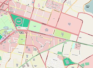
Country:
 India
IndiaRegion:
City:
Latitude and Longitude:
Time Zone:
Postal Code:
IP information under different IP Channel
ip-api
Country
Region
City
ASN
Time Zone
ISP
Blacklist
Proxy
Latitude
Longitude
Postal
Route
IPinfo
Country
Region
City
ASN
Time Zone
ISP
Blacklist
Proxy
Latitude
Longitude
Postal
Route
MaxMind
Country
Region
City
ASN
Time Zone
ISP
Blacklist
Proxy
Latitude
Longitude
Postal
Route
Luminati
Country
INRegion
ka
City
bengaluru
ASN
Time Zone
Asia/Kolkata
ISP
DIGITALOCEAN-ASN
Latitude
Longitude
Postal
db-ip
Country
Region
City
ASN
Time Zone
ISP
Blacklist
Proxy
Latitude
Longitude
Postal
Route
ipdata
Country
Region
City
ASN
Time Zone
ISP
Blacklist
Proxy
Latitude
Longitude
Postal
Route
Popular places and events near this IP address

M. Chinnaswamy Stadium
Cricket stadium in Bangalore city, Karnataka, India
Distance: Approx. 499 meters
Latitude and longitude: 12.97880556,77.59955556
The M. Chinnaswamy Stadium, also known as the Karnataka State Cricket Association Stadium, is a cricket stadium in the Bangalore city of the Indian state of Karnataka. The ground is owned by Government of Karnataka and operated by Karnataka State Cricket Association (KSCA). Flanked by the picturesque Cubbon Park, Queen's Road, Cubbon and uptown MG Road, this five-decade-old stadium is situated in the heart of the city of Bangalore.

St Joseph's Boys' High School, Bangalore
Private primary and secondary school in Bangalore, Karnataka, India
Distance: Approx. 591 meters
Latitude and longitude: 12.970895,77.603559
St Joseph's Boys' High School (formerly St. Joseph's European High School) is a private Catholic primary and senior secondary school located on Museum Road in Bangalore, Karnataka, India. Founded by the MEP (French Missionaries) in 1858, the school caters to boys only from kindergarten to Grade 10 and is co-educational in Grades 11 and 12.
St. Joseph's Pre-University College
Jesuit, catholic school in Bangalore, Karnataka, India
Distance: Approx. 578 meters
Latitude and longitude: 12.97108889,77.60421389
St. Joseph’s Pre-University College (SJPUC) is an educational institution located in Bangalore, India. The college is managed by the Society of Jesus (Jesuits).
Brigade Road
Road and shopping hub in central Bangalore
Distance: Approx. 528 meters
Latitude and longitude: 12.973801,77.6075
Brigade Road is a large commercial centre and one of the busiest shopping areas in the heart of Bangalore, the capital of Karnataka State, India. It is a one-way connecting road from M G Road to Hosur Road, also connecting Residency Road and Church Street on the way.
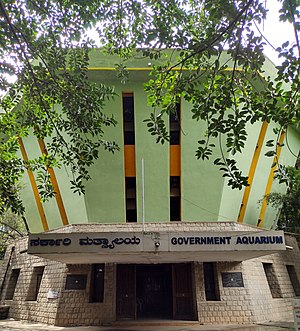
Bangalore Aquarium
Zoo in Karnataka, India
Distance: Approx. 511 meters
Latitude and longitude: 12.9765,77.5986
Bangalore Aquarium, also known as Government Aquarium, is the second largest aquarium in India. It is located at the entrance of Cubbon Park in Bangalore, India, and was established in 1983. It has a variety of exotic cultivable as well as ornamental fish on display.
Mahatma Gandhi Road metro station (Bangalore)
Namma Metro's Purple & Pink Line interchange station
Distance: Approx. 390 meters
Latitude and longitude: 12.975536,77.60683
Mahatma Gandhi Road (commonly referred to as MG Road) is an elevated metro station on the East-West corridor of the Purple Line of Namma Metro in Bangalore, India. It was constructed by Punj Lloyd and opened to the public on 20 October 2011. The station MG Road has a bicycle stand next to the Urban Square, from where commuters can rent cycles.
2010 Bangalore stadium bombing
Distance: Approx. 499 meters
Latitude and longitude: 12.97880556,77.59955556
2010 Bangalore stadium bombing occurred on 17 April 2010 in M. Chinnaswamy Stadium, Bangalore, India before a 2010 Indian Premier League match between the Royal Challengers Bangalore and Mumbai Indians. Two bombs exploded around a heavily packed Cricket stadium in which fifteen people were injured. A third bomb was defused outside the stadium.

St. Mark's Cathedral, Bangalore
Church in Bangalore, India
Distance: Approx. 342 meters
Latitude and longitude: 12.9760281,77.6001531
St. Mark's Cathedral, dedicated to Saint Mark the Evangelist, is the cathedral (Ecclesia Matar) of the Diocese of Central Karnataka of the Church of South India. The cathedral church, noted for its English Baroque architecture inspired by the 17th century St Paul's Cathedral, is located at the west end of Mahatma Gandhi Road, MacIver Town, Bangalore.
St. Andrew's Church, Bangalore
Church in Bangalore, India
Distance: Approx. 351 meters
Latitude and longitude: 12.979232,77.604188
St. Andrew's Church [1], consecrated in 1866, is a Presbyterian church, located on Cubbon Road, Bangalore. Initially knows as St.

Statue of Queen Victoria, Bangalore
Public sculpture by Thomas Brock
Distance: Approx. 493 meters
Latitude and longitude: 12.9768354,77.5988017
The Statue of Queen Victoria, Bangalore, is located at Queen's Park, next to Cubbon Park, Bangalore Cantonment, at the junction of 3 roads, at the border between the Cantonment and the Bangalore Pete. The statue was unveiled on 5 February 1906 by the then Prince of Wales, George Frederick Ernest Albert (who later became King George V). The statue was raised out of funds raised by the residents of the Bangalore Civil and Military Station and contributions made by Krishna Raja Wadiyar IV, the Maharaja of Mysore.

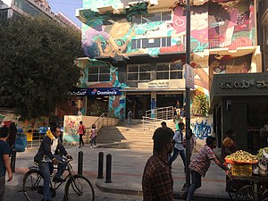
Church Street, Bangalore
Street in Bangalore, India
Distance: Approx. 209 meters
Latitude and longitude: 12.975006,77.604785
Church Street is a busy street in the Central Business District of Bangalore, India. It is a 750-metre stretch from Brigade Road to St. Mark's Road, running parallel to M G Road.
Sandesh Museum of Communication
Museum in Bangalore, India
Distance: Approx. 376 meters
Latitude and longitude: 12.97286,77.60379
Sandesh Museum of Communication is a museum in Bangalore and is dedicated to the postal history of India and different modes of communication. The museum opened its doors in 2019 and is located inside a 140 year-old post office, preserved and refurbished as a museum.
Weather in this IP's area
broken clouds
25 Celsius
25 Celsius
24 Celsius
26 Celsius
1009 hPa
76 %
1009 hPa
909 hPa
6000 meters
7.72 m/s
270 degree
75 %
06:03:59
18:47:58