Country:
 USA
USARegion:
City:
Latitude and Longitude:
Time Zone:
Postal Code:
IP information under different IP Channel
ip-api
Country
Region
City
ASN
Time Zone
ISP
Blacklist
Proxy
Latitude
Longitude
Postal
Route
IPinfo
Country
Region
City
ASN
Time Zone
ISP
Blacklist
Proxy
Latitude
Longitude
Postal
Route
MaxMind
Country
Region
City
ASN
Time Zone
ISP
Blacklist
Proxy
Latitude
Longitude
Postal
Route
Luminati
Country
USASN
Time Zone
America/Chicago
Latitude
Longitude
Postal
db-ip
Country
Region
City
ASN
Time Zone
ISP
Blacklist
Proxy
Latitude
Longitude
Postal
Route
ipdata
Country
Region
City
ASN
Time Zone
ISP
Blacklist
Proxy
Latitude
Longitude
Postal
Route
Popular places and events near this IP address
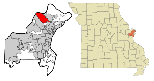
Hazelwood, Missouri
City in Missouri, United States
Distance: Approx. 1502 meters
Latitude and longitude: 38.77944444,-90.35638889
Hazelwood is a city in St. Louis County, Missouri, within Greater St. Louis.
Hazelwood West High School
Public school in St. Louis County, Missouri
Distance: Approx. 1215 meters
Latitude and longitude: 38.78611111,-90.38194444
Hazelwood West High School is a public high school located in Hazelwood, Missouri. It is one of three high schools in Hazelwood School District (HSD) in St. Louis County, Missouri, the others being Hazelwood Central High School and Hazelwood East High School.
St. Louis Assembly Plant
Distance: Approx. 1491 meters
Latitude and longitude: 38.77111111,-90.35833333
St. Louis Assembly Plant was an automobile factory owned by Ford Motor Company in Hazelwood, Missouri. It was opened in 1948 and was closed in 2006; it was idled as part of Ford's "The Way Forward" plan.

Urshan Graduate School of Theology
Distance: Approx. 2897 meters
Latitude and longitude: 38.8025,-90.3647
Urshan Graduate School of Theology (UGST) is a private seminary affiliated with the United Pentecostal Church International (UPCI) and located in Wentzville, Missouri. It opened in 2001 as a Oneness Pentecostal seminary.

St. Stanislaus Seminary
United States historic place
Distance: Approx. 2776 meters
Latitude and longitude: 38.80166667,-90.36611111
St. Stanislaus Seminary is a former Society of Jesus (Jesuits) seminary that was founded in 1823 on the outskirts of Florissant, Missouri within the current municipal limits of Hazelwood, Missouri. It was the longest continuously operated Jesuit novitiate in the United States.

Urshan College
Distance: Approx. 2707 meters
Latitude and longitude: 38.801,-90.366
Urshan College, formerly known as Gateway College of Evangelism, is a Christian seminary in Wentzville, Missouri. It is owned and operated by the United Pentecostal Church International (UPCI). In 2012, the college was acquired by Urshan Graduate School of Theology.
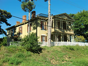
John B. Myers House and Barn
Historic house in Missouri, United States
Distance: Approx. 3150 meters
Latitude and longitude: 38.77638889,-90.33722222
John B. Myers House and Barn in Florissant, Missouri is listed on the National Register of Historic Places in Missouri. The house, a Classical Revival building built in 1878, was listed in 1974 as John B. Myers House. The listing name and boundary were increased to include the barn, built in 1867, in 1977.
Chicago and Southern Flight 4
1936 aviation accident
Distance: Approx. 3372 meters
Latitude and longitude: 38.80762222,-90.37094444
Chicago and Southern Air Lines Flight 4 was a regularly scheduled flight from New Orleans, Louisiana to Chicago, Illinois via Jackson, Mississippi; Memphis, Tennessee; and St. Louis, Missouri operated with a Lockheed Model 10 Electra. On August 5, 1936, after departing from Lambert-St.
Ferguson Township, St. Louis County, Missouri
Township in the U.S. state of Missouri
Distance: Approx. 3274 meters
Latitude and longitude: 38.74833333,-90.36777778
Ferguson Township is a township in St. Louis County, in the U.S. state of Missouri. Its population was 34,923 as of the 2010 census.
Henry VIII Hotel
American defunct hotel
Distance: Approx. 2555 meters
Latitude and longitude: 38.759421,-90.391807
The Henry VIII Hotel, also known as The Henry VIII Inn and Lodge, was a hotel of Tudor Revival architecture which was located near the St. Louis Lambert International Airport with an address of 4690 North Lindbergh Boulevard, Bridgeton, Missouri. The hotel remained in business until 2000 when it was removed to expand a runway area for the nearby airport.

Sacred Heart Cemetery
Roman Catholic cemetery in Florissant, St. Louis County, Missouri
Distance: Approx. 3497 meters
Latitude and longitude: 38.7815889,-90.3335648
Sacred Heart Cemetery is a Catholic Cemetery located in the Florissant suburb of St. Louis, Missouri.

Ozark Air Lines Flight 965
1968 mid-air collision in St. Louis, Missouri
Distance: Approx. 3107 meters
Latitude and longitude: 38.75,-90.36666667
Ozark Air Lines Flight 965 was a scheduled commercial flight from Chicago, Illinois, to Lambert Field in St. Louis, Missouri, with a scheduled intermediate stopover at Greater Peoria Regional Airport in Peoria, Illinois. On March 27, 1968, the Douglas DC-9-15 jetliner operating the flight, carrying 44 passengers and five crew, collided in mid-air with a single-engined Cessna 150F while both aircraft were on approach to the same runway at Lambert Field.
Weather in this IP's area
clear sky
20 Celsius
21 Celsius
19 Celsius
22 Celsius
1017 hPa
92 %
1017 hPa
997 hPa
10000 meters
1.54 m/s
70 degree
05:58:44
20:17:01