Country:
 Finland
Region:
City:
Latitude and Longitude:
Time Zone:
Postal Code:
IP information under different IP Channel
ip-api
Country
Region
City
ASN
Time Zone
ISP
Blacklist
Proxy
Latitude
Longitude
Postal
Route
IPinfo
Country
Region
City
ASN
Time Zone
ISP
Blacklist
Proxy
Latitude
Longitude
Postal
Route
MaxMind
Country
Region
City
ASN
Time Zone
ISP
Blacklist
Proxy
Latitude
Longitude
Postal
Route
Luminati
Country
FIASN
Time Zone
Europe/Helsinki
ISP
Telia Finland Oyj
Latitude
Longitude
Postal
db-ip
Country
Region
City
ASN
Time Zone
ISP
Blacklist
Proxy
Latitude
Longitude
Postal
Route
ipdata
Country
Region
City
ASN
Time Zone
ISP
Blacklist
Proxy
Latitude
Longitude
Postal
Route
Popular places and events near this IP address

Anjalankoski
Town in Kymenlaakso, Finland
Distance: Approx. 7444 meters
Latitude and longitude: 60.75,26.82361111
Anjalankoski is a former town and municipality of Finland. It had 16 379 inhabitants in 2008. About 4/5 of the people live in the vicinity of the Kymi River.
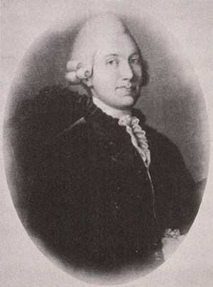
Anjala conspiracy
Scheme by disgruntled Swedish officers to end Gustav III's Russian War of 1788–90
Distance: Approx. 1801 meters
Latitude and longitude: 60.69638889,26.81388889
The Anjala conspiracy (Swedish: Anjalaförbundet, Finnish: Anjalan liitto) of 1788 was a scheme by disgruntled Swedish officers to end Gustav III's Russian War of 1788–1790. Declaring Finland an independent state was not a part of the original plot, but one of the conspirators Johan Anders Jägerhorn, who handed the note to Empress Catherine the Great, made such claims in Saint Petersburg.

Anjala
Distance: Approx. 1509 meters
Latitude and longitude: 60.68873,26.80793
Anjala was a town in Southern Finland, which merged in 1975 with Sippola to form Anjalankoski, later further merged into Kouvola. Anjala is remembered historically in connection with the 18th-century event known as the Anjala Conspiracy. The Regina School, one of the country's first public schools, was located here, as was its library, which was the first in the country.
Wredeby Airfield
Airport in Kouvola, Finland
Distance: Approx. 5248 meters
Latitude and longitude: 60.66361111,26.74583333
Wredeby Airfield (ICAO: EFWB) is an aerodrome located in Kouvola, Finland, about 7 kilometres (4 mi) southwest of Anjalankoski.
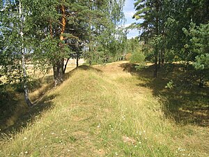
Liikkala Fortress
Fortress in Kouvola, Finland
Distance: Approx. 9649 meters
Latitude and longitude: 60.7047,27.0049
Liikkala Fortress is a fortress in Kouvola, Finland. It was built in 1790s as a part of a larger South-Eastern Finland fortification system to protect Saint Petersburg, the capital of the Russian Empire. Liikkala is located at the crossroad of four roads from Anjala, Hamina, Kouvola and Kaipiainen.

Myllykoski railway station
Railway station in Kouvola, Finland
Distance: Approx. 9957 meters
Latitude and longitude: 60.77,26.78833333
The Myllykoski railway station (Finnish: Myllykosken rautatieasema, Swedish: Myllykoski järnvägsstation) is located in the town of Kouvola (formerly the municipality of Anjalankoski), Finland, in the urban area of Myllykoski. It is located along the Kouvola–Kotka railway, and its neighboring stations are Kouvola in the north and Inkeroinen in the south.

Inkeroinen railway station
Railway station in Kouvola, Finland
Distance: Approx. 1544 meters
Latitude and longitude: 60.69683333,26.8395
The Inkeroinen railway station (Finnish: Inkeroisten rautatieasema, Swedish: Inkeroinen järnvägsstation, formerly Inkerois) is located in the town of Kouvola (formerly the town of Anjalankoski), Finland, in the urban area of Inkeroinen. It is located along the Kouvola–Kotka railway, and its neighboring stations are Myllykoski in the north and Tavastila in the south.
Weather in this IP's area
few clouds
28 Celsius
28 Celsius
27 Celsius
28 Celsius
1012 hPa
52 %
1012 hPa
1009 hPa
10000 meters
3.45 m/s
4.17 m/s
199 degree
13 %
04:37:11
22:00:55