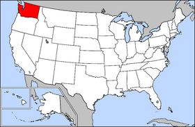
Country:
 USA
USARegion:
City:
Latitude and Longitude:
Time Zone:
Postal Code:
IP information under different IP Channel
ip-api
Country
Region
City
ASN
Time Zone
ISP
Blacklist
Proxy
Latitude
Longitude
Postal
Route
IPinfo
Country
Region
City
ASN
Time Zone
ISP
Blacklist
Proxy
Latitude
Longitude
Postal
Route
MaxMind
Country
Region
City
ASN
Time Zone
ISP
Blacklist
Proxy
Latitude
Longitude
Postal
Route
Luminati
Country
USASN
Time Zone
America/Chicago
ISP
NET-PROVPHP
Latitude
Longitude
Postal
db-ip
Country
Region
City
ASN
Time Zone
ISP
Blacklist
Proxy
Latitude
Longitude
Postal
Route
ipdata
Country
Region
City
ASN
Time Zone
ISP
Blacklist
Proxy
Latitude
Longitude
Postal
Route
Popular places and events near this IP address
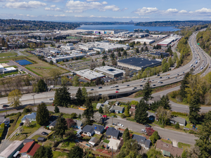
Renton, Washington
City in Washington, United States
Distance: Approx. 540 meters
Latitude and longitude: 47.48666667,-122.19527778
Renton is a city in King County, Washington, United States, and an inner-ring suburb of Seattle. Situated 11 miles (18 km) southeast of downtown Seattle, Renton straddles the southeast shore of Lake Washington, at the mouth of the Cedar River. As of the 2020 census, the population of Renton was 106,785, up from 90,927 at the 2010 census.
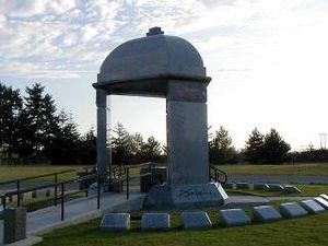
Greenwood Memorial Park (Renton, Washington)
Distance: Approx. 2001 meters
Latitude and longitude: 47.48787,-122.17151
Greenwood Memorial Park is a cemetery in the northwest United States, located in Renton, Washington, a suburb southeast of Seattle. It is notable as the resting place of rock guitarist Jimi Hendrix (1942–1970), a Seattle native; over 14,000 fans visit his memorial annually. Also interred at Greenwood are professional football players Clancy Williams (1942–1986) and Nesby Glasgow (1957–2020).
Washington Interscholastic Activities Association
Distance: Approx. 835 meters
Latitude and longitude: 47.477,-122.205
The Washington Interscholastic Activities Association (WIAA) is the governing body of athletics and activities for secondary education schools in the state of Washington. As of February 2011, the private, 501(c)(3) nonprofit organization consists of nearly 800 member high schools and middle/junior high schools, both public and private.

Cedar River Trail
Hiking trail
Distance: Approx. 261 meters
Latitude and longitude: 47.480257,-122.19908
The Cedar River Regional Trail is a partially paved 17.3-mile (27.8 km) rail trail in Washington. The Cedar River Trail was the former mainline of the Milwaukee Road. It is open for non-motorized use and parallels State Route 169 for much of its length.
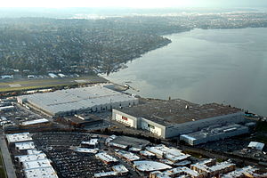
Boeing Renton Factory
Airplane assembly facility in Renton, Washington
Distance: Approx. 2151 meters
Latitude and longitude: 47.49934,-122.2089
The Boeing Renton Factory is the Boeing Company's manufacturing facility for narrow-body commercial airliners, and their military derivatives. Production includes the Boeing 737 MAX passenger airliner and the Boeing P-8 Poseidon military patrol aircraft. The factory covers 1,100,000 square feet (100,000 m2) of floor space.
Renton High School
Free public school in Renton, Washington, United States
Distance: Approx. 1138 meters
Latitude and longitude: 47.48277778,-122.21166667
Renton High School is a public secondary school (grades 9–12) in downtown Renton, Washington, U.S., about 10 miles southeast of downtown Seattle. Founded in 1911, it is the oldest high school in the Renton School District.

Renton History Museum
Distance: Approx. 549 meters
Latitude and longitude: 47.4801,-122.2034
The Renton History Museum is a repository for objects and archives significant to the city of Renton in the state of Washington, United States. The museum has objects and archives of Renton's history and has exhibits and public programs for the community and visitors. It is a joint initiative between the city of Renton and the Renton Historical Society, a non-profit organization providing private sector support for the museum.
Renton Technical College
Distance: Approx. 1886 meters
Latitude and longitude: 47.49166667,-122.17611111
Renton Technical College (Renton Tech or RTC) is a public community college in Renton, Washington. The college offers bachelor's degrees, associate degrees and certificates of completion in professional-technical fields.
Renton School District
Public school district headquartered in Renton, Washington, USA
Distance: Approx. 1997 meters
Latitude and longitude: 47.47416667,-122.22055556
Renton School District 403 is a public school district headquartered in Renton, Washington, USA. The district boundaries include the vast majority of Renton, all of Bryn Mawr-Skyway, and portions of the adjacent cities and communities of Bellevue, East Renton Highlands, Fairwood, Kent, Newcastle, SeaTac, and Tukwila. On October 1 of the 2017-2018 school year, the district has an enrollment of 16,336 students.

Renton Public Library
Distance: Approx. 406 meters
Latitude and longitude: 47.482,-122.202
The Renton Public Library is the King County Library System (KCLS) branch library in Renton, Washington, in the United States. It was a city library between its construction in 1966 and 2010, when it was one of the last three non-KCLS members in the county outside of Seattle and it was incorporated into KCLS after what may have been "the most contentious annexation fight in the system's 71 years".
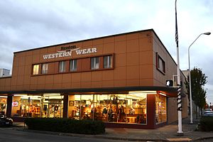
F. W. Woolworth Company Store (Renton, Washington)
United States historic place
Distance: Approx. 815 meters
Latitude and longitude: 47.47985833,-122.20700278
The F. W. Woolworth Company Store Renton is a commercial building in Renton, Washington. Built in 1954, it was listed in the National Register of Historic Places in 2015 for its direct association with growth and development of downtown Renton, and for its connection to the national five-and dime chain store, F.W. Woolworth Company. The building is now a Western Wear store.
Southport (Renton, Washington)
Mixed-use development in Renton, Washington, United States
Distance: Approx. 2383 meters
Latitude and longitude: 47.50277778,-122.20361111
Southport is a mixed-use development in Renton, Washington, United States. It is located on the southern shore of Lake Washington adjacent to the Renton Landing lifestyle center and the Boeing Renton Factory.
Weather in this IP's area
overcast clouds
15 Celsius
14 Celsius
13 Celsius
16 Celsius
1013 hPa
77 %
1013 hPa
1011 hPa
10000 meters
3.58 m/s
6.26 m/s
66 degree
100 %
05:41:07
20:49:13