Country:
 Netherlands
Region:
City:
Latitude and Longitude:
Time Zone:
Postal Code:
IP information under different IP Channel
ip-api
Country
Region
City
ASN
Time Zone
ISP
Blacklist
Proxy
Latitude
Longitude
Postal
Route
IPinfo
Country
Region
City
ASN
Time Zone
ISP
Blacklist
Proxy
Latitude
Longitude
Postal
Route
MaxMind
Country
Region
City
ASN
Time Zone
ISP
Blacklist
Proxy
Latitude
Longitude
Postal
Route
Luminati
Country
NLRegion
ge
City
deheurne
ASN
Time Zone
Europe/Amsterdam
ISP
Odido Netherlands B.V.
Latitude
Longitude
Postal
db-ip
Country
Region
City
ASN
Time Zone
ISP
Blacklist
Proxy
Latitude
Longitude
Postal
Route
ipdata
Country
Region
City
ASN
Time Zone
ISP
Blacklist
Proxy
Latitude
Longitude
Postal
Route
Popular places and events near this IP address

Groningen
City and municipality in the Netherlands
Distance: Approx. 48 meters
Latitude and longitude: 53.21888889,6.5675
Groningen ( GROH-ning-ən, UK also GRON-ing-ən, Dutch: [ˈɣroːnɪŋə(n)] ; Gronings: Grunn or Grunnen) is the capital city and main municipality of Groningen province in the Netherlands. Dubbed the "capital of the north", Groningen is the largest place as well as the economic and cultural centre of the northern part of the country; as of December 2021, it had 235,287 inhabitants, making it the sixth largest city/municipality in the Netherlands and the second largest outside the Randstad. Groningen was established more than 950 years ago and gained city rights in 1245.

Ems-Occidental
Distance: Approx. 279 meters
Latitude and longitude: 53.2167,6.56667
Ems-Occidental (French: [ɛms ɔk.si.dɑ̃.tal], "Western Ems; Dutch: Wester Eems, German: West-Ems) was a department of the First French Empire in the present-day Netherlands and Germany. It was formed in 1810, when the Kingdom of Holland was annexed by France. Its territory corresponded more or less with the present Dutch provinces of Groningen and Drenthe.
Groninger Studentencorps Vindicat atque Polit
Dutch student association
Distance: Approx. 116 meters
Latitude and longitude: 53.218717,6.568542
The Groninger Studenten Corps Vindicat atque Polit (Latin for Uphold and Refine (lit. (The sword) avenges and (the file) scrapes)) is the second oldest Dutch student association and was founded on February 4, 1815, as a reaction to attacks on students from local citizens. The first rector of the senate was B.J. Winter.

Martinikerk (Groningen)
Church in Groningen , Netherlands
Distance: Approx. 89 meters
Latitude and longitude: 53.21916667,6.56833333
The Martinikerk (Martin's church) is the oldest church in Groningen, Netherlands. The church and its associated tower (the Martinitoren) are named after Saint Martin of Tours (316–397), the patron saint of the Bishopric of Utrecht to which Groningen belonged. The church was a cathedral for a short period during the first bishopric of Groningen (1559–1594).
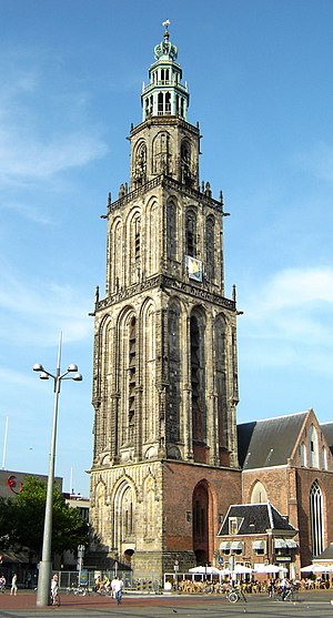
Martinitoren
Church building in Groningen, Netherlands
Distance: Approx. 67 meters
Latitude and longitude: 53.21921,6.568
The Martinitoren (Dutch pronunciation: [mɑrˈtinitoːrə(n)]; Martini or St. Martin's Tower) is the tallest church steeple in the city of Groningen, Netherlands, and the bell tower of the Martinikerk. The tower is located at the north-eastern corner of the Grote Markt (Main Market Square).

Battle of Groningen
Second World War battle from April 14–18, 1945
Distance: Approx. 68 meters
Latitude and longitude: 53.2186,6.5672
The Battle of Groningen took place during the penultimate month of World War II in Europe, on 13 to 16 April 1945, in the city of Groningen. The 2nd Canadian Division attacked Groningen (though the whole division was never in combat at any given time), defended by 7,000 German soldiers and Dutch and Belgian SS troops. There were also many Luftwaffe troops manning flak guns in the area.
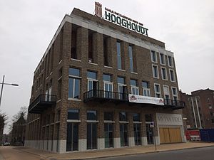
Forum Groningen
Cultural center in Groningen
Distance: Approx. 220 meters
Latitude and longitude: 53.21880556,6.57023611
Forum Groningen is a cultural center in the city of Groningen in the northern Netherlands that houses a library, cinema, and parts of the Groninger Museum. Forum Groningen opened in November 2019, and is expected to receive 1.6 million visitors annually. The center is located next to the Great Market Square and the New Market and is part of larger reconstruction plans of the Great Market Square's eastern side.

Goudkantoor
Building in Groningen, Netherlands
Distance: Approx. 113 meters
Latitude and longitude: 53.21833333,6.56611111
The Goudkantoor (English: Gold Office) is a building built in 1635 and located on Waagstraat near the Grote Markt (Main Square) in Groningen, Netherlands. Originally it was built as an office for the receiver of the province of Groningen when it was called Collectehuis. The text on the building, Date Caesari quae sunt Caesaris (Latin) (English: Render unto Caesar that which is Caesar's) refers to the original function.

Siege of Groningen (1672)
1672 battle in the Franco-Dutch War
Distance: Approx. 68 meters
Latitude and longitude: 53.2186,6.5672
The Siege of Groningen was a battle that took place in 1672 during the Franco-Dutch war. It was a Dutch victory that ended all hope of the Bishop of Münster to push deeper into the Netherlands. The Münster army was so weakened by the defeat that the Dutch army successfully reconquered much of the land that Münster had conquered just weeks earlier.

Broerkerk
Church in Groningen, Netherlands
Distance: Approx. 265 meters
Latitude and longitude: 53.21888889,6.56305556
The Broerkerk in Groningen, Netherlands, was a medieval church connected to the Franciscan cloister in Groningen. The church was situated in the Broerstraat in Groningen. The Broerkerk was the first church in the town used by the Protestants.
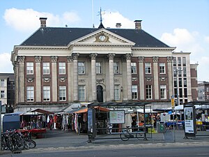
Groningen City Hall
Seat of local government in Groningen
Distance: Approx. 99 meters
Latitude and longitude: 53.21833333,6.56666667
Groningen City Hall is the seat of government in Groningen, the Netherlands. The city council meets in a modern room downstairs, but upstairs in the former raadszaal the Gulden Boek is kept that lists the honored citizens of the town.
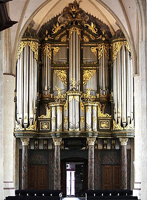
Organ in the Martinikerk at Groningen
Historic organ in Groningen, Netherlands
Distance: Approx. 89 meters
Latitude and longitude: 53.21916667,6.56833333
The west gallery organ of the Martinikerk in Groningen dates from the 15th century; it took its present form in the 18th century when it was expanded by Arp Schnitger, his son Franz Caspar Schnitger and his successor Albertus Antonius Hinsz. It has 52 speaking stops on three manuals and pedal, and is one of the largest and most famous baroque organs in Northern Europe.
Weather in this IP's area
scattered clouds
14 Celsius
14 Celsius
13 Celsius
16 Celsius
1013 hPa
97 %
1013 hPa
1012 hPa
9000 meters
0.51 m/s
40 %
05:42:57
21:37:17