Country:
 C_te d'Ivoire
Region:
City:
Latitude and Longitude:
Time Zone:
Postal Code:
IP information under different IP Channel
ip-api
Country
Region
City
ASN
Time Zone
ISP
Blacklist
Proxy
Latitude
Longitude
Postal
Route
IPinfo
Country
Region
City
ASN
Time Zone
ISP
Blacklist
Proxy
Latitude
Longitude
Postal
Route
MaxMind
Country
Region
City
ASN
Time Zone
ISP
Blacklist
Proxy
Latitude
Longitude
Postal
Route
Luminati
Country
CIASN
Time Zone
Africa/Abidjan
ISP
MTNCI-AS
Latitude
Longitude
Postal
db-ip
Country
Region
City
ASN
Time Zone
ISP
Blacklist
Proxy
Latitude
Longitude
Postal
Route
ipdata
Country
Region
City
ASN
Time Zone
ISP
Blacklist
Proxy
Latitude
Longitude
Postal
Route
Popular places and events near this IP address

Felix Houphouet Boigny Stadium
Multi-use stadium in Abidjan, Ivory Coast
Distance: Approx. 2111 meters
Latitude and longitude: 5.32825,-4.01841667
The Felix Houphouet Boigny Stadium, nicknamed Le Félicia, is a multi-purpose stadium, which can host football, rugby union and athletics, in Abidjan, Ivory Coast. It is the former national stadium of the Ivory Coast national football team. It is named after the first president of the country, Félix Houphouët-Boigny, and is located in the commune of Le Plateau.
National Assembly (Ivory Coast)
Distance: Approx. 2198 meters
Latitude and longitude: 5.3290193,-4.02017308
The National Assembly is lower house of the Parliament of Ivory Coast since November 2016. From 1960 to 2016, the National Assembly was Ivory Coast's unicameral legislative body. Evolved from semi-representative bodies of the French Colonial period, the first National Assembly was constituted on 27 November 1960 with 70 elected members (députés) in accordance with the Constitution of 31 October 1960, which created the First Republic.

Palais des Sports de Treichville
Indoor sporting arena located in Treichville, Abidjan, Ivory Coas
Distance: Approx. 1987 meters
Latitude and longitude: 5.29805556,-4.00527778
Palais des Sports de Treichville is an indoor sporting arena located in Treichville, Abidjan, Ivory Coast. The capacity of the arena is 3,500 people.
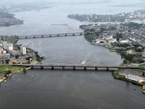
Houphouët-Boigny Bridge
Distance: Approx. 310 meters
Latitude and longitude: 5.31208333,-4.01930556
Houphouët-Boigny Bridge is a road and rail bridge over the Ébrié Lagoon which links the two halves of the city Abidjan in Ivory Coast. The structure is a girder bridge, hollow box, double deck bridge with eight spans of 46.5 m (153 ft), each thus resulting a total length of 372 m (1,220 ft).

Second Abidjan Bridge
Distance: Approx. 1233 meters
Latitude and longitude: 5.315845,-4.010224
Second Abidjan Bridge is a road bridge over the Ébrié Lagoon which links the two halves of the city of Abidjan in Côte d'Ivoire. The structure is a girder bridge, hollow box bridge with ten spans, two spans of 35 m and eight spans of 58 m each thus resulting a total length of 592 m.
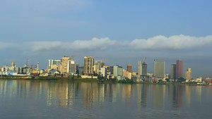
Abidjan
Largest city and district of Ivory Coast
Distance: Approx. 1768 meters
Latitude and longitude: 5.31666667,-4.03333333
Abidjan ( AB-ih-JAHN, French: [abidʒɑ̃]; N'ko: ߊߓߌߖߊ߲߬) is the largest city and the former capital of the Ivory Coast. As of the 2021 census, Abidjan's population was 6.3 million, which is 21.5 percent of overall population of the country, making it the sixth most populous city proper in Africa, after Lagos, Cairo, Kinshasa, Dar es Salaam, and Johannesburg. A cultural crossroads of West Africa, Abidjan is characterised by a high level of industrialisation and urbanisation.

Plateau, Ivory Coast
Urban commune and central business district of Abidjan in Ivory Coast
Distance: Approx. 867 meters
Latitude and longitude: 5.31666667,-4.01666667
The Plateau is the central business district of Abidjan, the economic capital of Côte d'Ivoire. It is one of the 10 urban communes of the city. The Plateau is surrounded by the municipality of Yopougon to the west, to the south by the Ébrié Lagoon.
Culture Palace of Abidjan
Temple of culture in Abidjan, Ivory Coast
Distance: Approx. 799 meters
Latitude and longitude: 5.31194444,-4.0125
Culture Palace of Abidjan (Palais de la Culture d'Abidjan) is a temple of culture in Abidjan, Ivory Coast (Côte d’Ivoire). The building is situated between the Houphouët-Boigny Bridge and the General de Gaulle Bridge. Culture Palace of Abidjan, with a capacity of 9,400 people, was bestowed to the Ivorian government as a gift from China.
Higher Institute of Technology of Ivory Coast
Private institution in Abidjan, Ivory Coast
Distance: Approx. 1927 meters
Latitude and longitude: 5.3264,-4.0219
The Higher Institute of Technology of Ivory Coast (French: Institut Supérieur de Technologie de Côte d'Ivoire (IST-CI)) is a private institution of higher education and research whose headquarters is in the district of Plateau in Abidjan, the economic capital of Ivory Coast.

2013 Houphouët-Boigny stampede
2013 human crush at a stadium in Abidjan, Ivory Coast
Distance: Approx. 2111 meters
Latitude and longitude: 5.32825,-4.01841667
The 2013 Houphouët-Boigny stampede was a crowd crush that occurred as crowds departed a New Year's Eve fireworks display in the early hours of 1 January 2013 near the Félix Houphouët-Boigny Stadium in Abidjan, Ivory Coast. It resulted in 61 deaths and over 200 injuries, mostly women and children. This was the second time in four years that a fatal crush incident occurred at the stadium.
La Pyramide (building)
Distance: Approx. 1480 meters
Latitude and longitude: 5.3223,-4.0164
La Pyramide is a high-rise building located in the Plateau area of Abidjan, the largest city in Ivory Coast. Construction of the building began in 1968 and was completed in 1973. It was designed by Italian architect Rinaldo Olivieri who aimed to capture the activity of an African market in an urban setting.
CCIA Building
Building in Ivory Coast
Distance: Approx. 2479 meters
Latitude and longitude: 5.331382,-4.022072
The CCIA Building, (long form Abidjan International Trade Center Building), is a skyscraper located on Rue Jean-Paul II, in the Plateau community of Abidjan, Côte d'Ivoire. Built in 1982 and topping out at 94 metres (308 ft) tall, it is the fourth-tallest building in Abidjan. It is part of a group of buildings planned in the 1970s and intended for use as offices and headquarters for publicly traded companies.
Weather in this IP's area
broken clouds
26 Celsius
26 Celsius
26 Celsius
26 Celsius
1016 hPa
89 %
1016 hPa
1015 hPa
9000 meters
2.57 m/s
240 degree
75 %
06:11:33
18:33:22