Country:
 USA
USARegion:
City:
Latitude and Longitude:
Time Zone:
Postal Code:
IP information under different IP Channel
ip-api
Country
Region
City
ASN
Time Zone
ISP
Blacklist
Proxy
Latitude
Longitude
Postal
Route
IPinfo
Country
Region
City
ASN
Time Zone
ISP
Blacklist
Proxy
Latitude
Longitude
Postal
Route
MaxMind
Country
Region
City
ASN
Time Zone
ISP
Blacklist
Proxy
Latitude
Longitude
Postal
Route
Luminati
Country
USASN
Time Zone
America/Chicago
Latitude
Longitude
Postal
db-ip
Country
Region
City
ASN
Time Zone
ISP
Blacklist
Proxy
Latitude
Longitude
Postal
Route
ipdata
Country
Region
City
ASN
Time Zone
ISP
Blacklist
Proxy
Latitude
Longitude
Postal
Route
Popular places and events near this IP address
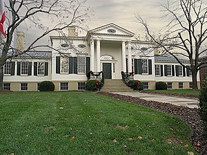
Taft Museum of Art
Historic house in Ohio, United States
Distance: Approx. 337 meters
Latitude and longitude: 39.1025,-84.50333333
The Taft Museum of Art is a fine art collection in Cincinnati, Ohio. It occupies the 200-year-old historic house at 316 Pike Street. The house – the oldest domestic wooden structure in downtown Cincinnati – was built about 1820 and housed several prominent Cincinnatians, including Martin Baum, Nicholas Longworth, David Sinton, Anna Sinton Taft and Charles Phelps Taft.

Mount Adams Incline
Former funicular railway
Distance: Approx. 260 meters
Latitude and longitude: 39.10658333,-84.49961111
The Mount Adams Incline was a funicular, or inclined railway, located in the Cincinnati neighborhood of Mount Adams. Completed in 1872, it was the longest-running of the city's five inclines, closing in 1948. It has since been demolished.

Lytle Tunnel
Vehicular tunnel in Cincinnati, Ohio, US
Distance: Approx. 449 meters
Latitude and longitude: 39.10166667,-84.50416667
The Lytle Tunnel is a vehicular tunnel that carries Interstate 71 (I-71) under the historic Lytle Park in Cincinnati, in the U.S. state of Ohio, connecting Fort Washington Way to the Northeast Expressway. It is a six-lane tunnel with three tubes. There is a two-lane southbound tube, a three lane-northbound tube, and a one-lane southbound tube that separates from the highway and serves as an exit ramp to the downtown area.

Literary Club of Cincinnati
United States historic place
Distance: Approx. 495 meters
Latitude and longitude: 39.10138889,-84.50466667
The Literary Club of Cincinnati is located at 500 East Fourth Street, across from Lytle Park in downtown Cincinnati, Ohio. The club occupies a two-story Greek Revival house which was built in 1820, on the site of the home of William Sargent, secretary of the Northwest Territory. The Club was founded in 1849; its membership is limited to 100 men.

Cincinnati Times-Star Building
United States historic place
Distance: Approx. 435 meters
Latitude and longitude: 39.105475,-84.50723889
Cincinnati Times-Star Building at 800 Broadway Street in Cincinnati, Ohio, is a registered historic building. It was listed in the National Register on November 25, 1983. It was built in 1933 and was designed by the firm of Samuel Hannaford & Sons in the Art Deco style.
Fenwick Club
United States historic place
Distance: Approx. 450 meters
Latitude and longitude: 39.1025,-84.50583333
The Fenwick Club was a historic building in downtown Cincinnati, Ohio, United States, which was constructed to serve a Catholic social organization for unmarried men. Although named a historic site in the 1970s because of its architecture, it is no longer standing. Founded in 1915, the Fenwick Club was organized to serve unmarried Catholic men under the age of 40 by providing them with space for cultural and social activities, as well as lodging space.

Holy Cross Monastery and Church
United States historic place
Distance: Approx. 391 meters
Latitude and longitude: 39.10743056,-84.49851111
Holy Cross Monastery and Church is a registered historic building complex in Cincinnati, Ohio, listed in the National Register on September 13, 1978. Closed in 1977, it is now the corporate headquarters of a property management company, and an event space.
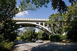
Ida Street Viaduct
United States historic place
Distance: Approx. 465 meters
Latitude and longitude: 39.10886111,-84.49919444
Ida Street Viaduct is a registered historic structure in Cincinnati, Ohio, listed in the National Register on November 28, 1980. The reinforced concrete bridge is located in the hilltop neighborhood of Mount Adams. The Ida Street Viaduct, constructed in 1931 in the Art Deco style, replaced a wooden trestle that carried Cincinnati streetcars.

Rookwood Pottery Company
United States historic place
Distance: Approx. 235 meters
Latitude and longitude: 39.10722222,-84.50083333
Rookwood Pottery is an American ceramics company that was founded in 1880 and closed in 1967, before being revived in 2004. It was initially located in the Over-the-Rhine neighborhood in Cincinnati, Ohio, and has now returned there. In its heyday from about 1890 to the 1929 Crash, it was an important manufacturer, mostly of decorative American art pottery made in several fashionable styles and types of pieces.
Hard Rock Casino Cincinnati
American casino
Distance: Approx. 467 meters
Latitude and longitude: 39.107948,-84.506493
Hard Rock Casino Cincinnati (formerly Jack Cincinnati Casino and Horseshoe Cincinnati) is a casino in Cincinnati, Ohio, owned by Vici Properties and operated by Hard Rock International. It opened in 2013.
Anna Louise Inn
Women's facility in Cincinnati, Ohio
Distance: Approx. 487 meters
Latitude and longitude: 39.101121,-84.503395
The Anna Louise Inn is a women's facility in Cincinnati, Ohio, providing affordable housing and supportive services to economically vulnerable single women, supporting them to reach greater self-sufficiency. It is operated by HER Cincinnati, formerly, Cincinnati Union Bethel (CUB), a charitable group founded in 1830. Since 1909, the Anna Louise Inn has provided safe and affordable housing for single women.

Statue of Abraham Lincoln (Cincinnati)
Public sculpture by George Grey Barnard
Distance: Approx. 505 meters
Latitude and longitude: 39.101168,-84.504299
An 11-foot (3.4 m) bronze statue of Abraham Lincoln is installed in Lytle Park within downtown Cincinnati, Ohio, United States. The Charles P. Taft family commissioned artist George Grey Barnard to complete a statue in commemoration of the centenary of Lincoln's birth. The sculpture was unveiled at Lytle Park on March 31, 1917.
Weather in this IP's area
clear sky
16 Celsius
16 Celsius
14 Celsius
18 Celsius
1020 hPa
83 %
1020 hPa
1000 hPa
10000 meters
06:34:25
20:54:22