Country:
 India
IndiaRegion:
City:
Latitude and Longitude:
Time Zone:
Postal Code:
IP information under different IP Channel
ip-api
Country
Region
City
ASN
Time Zone
ISP
Blacklist
Proxy
Latitude
Longitude
Postal
Route
IPinfo
Country
Region
City
ASN
Time Zone
ISP
Blacklist
Proxy
Latitude
Longitude
Postal
Route
MaxMind
Country
Region
City
ASN
Time Zone
ISP
Blacklist
Proxy
Latitude
Longitude
Postal
Route
Luminati
Country
INRegion
tn
City
chennai
ASN
Time Zone
Asia/Kolkata
ISP
Hathway IP Over Cable Internet
Latitude
Longitude
Postal
db-ip
Country
Region
City
ASN
Time Zone
ISP
Blacklist
Proxy
Latitude
Longitude
Postal
Route
ipdata
Country
Region
City
ASN
Time Zone
ISP
Blacklist
Proxy
Latitude
Longitude
Postal
Route
Popular places and events near this IP address

Madras Medical College
Medical school and hospital in Chennai, India
Distance: Approx. 700 meters
Latitude and longitude: 13.081621,80.278865
Madras Medical College (MMC) is a public medical college located in Chennai, Tamil Nadu, India. Established in 1835, it is one of the oldest medical colleges in India, as well as in Asia.

Sowcarpet
Neighbourhood in Chennai, Tamil Nadu, India
Distance: Approx. 185 meters
Latitude and longitude: 13.0895,80.27897
Sowcarpet is a neighborhood in the northern part of Chennai, India. Sowcarpet is one of the oldest neighborhoods of the city with narrow streets and vintage buildings. It is a bustling commercial area of the city, and a range of wholesale markets are located here.

Chennai Fort railway station
Railway station in Chennai, India
Distance: Approx. 687 meters
Latitude and longitude: 13.08319,80.28259
Chennai Fort (formerly known as Madras Fort) (station code: MSF) is a station on the Chennai Suburban Railway and Chennai MRTS. It is the second station on the Chennai MRTS line from Chennai Beach to Velachery.
Broadway bus terminus
Bus terminus in Chennai, India
Distance: Approx. 577 meters
Latitude and longitude: 13.0874,80.2838
Broadway Bus Terminus is the largest city bus terminus of the Metropolitan Transport Corporation (Chennai), Chennai, Tamil Nadu, India. It is located in the downtown area of the city, viz. Parry's corner and Fort.
Raja Annamalai Chettiar Hall
Distance: Approx. 665 meters
Latitude and longitude: 13.085853,80.284258
The Raja Annamalai Chettiar Hall is an auditorium situated in Chennai, India. It is considered to be one of the city's oldest venues for Carnatic music concerts apart from the T. T. Krishnamachari Auditorium in Mylapore. The auditorium is the venue for concerts organised by the Tamil Isai Sangam.

Ekambareswarar Temple, Chennai
Hindu temple in Tamil Nadu, India
Distance: Approx. 32 meters
Latitude and longitude: 13.08817,80.2784
Ekambareswarar Temple, Chennai is a Hindu temple situated in the neighbourhood of Parry's corner (George Town), Chennai, India dedicated to Shiva. It was constructed by Alanganatha Pillai, chief merchant of the Madras factory of the British East India Company.
Tamil Nadu Public Service Commission
State government agency
Distance: Approx. 484 meters
Latitude and longitude: 13.0852,80.282
The Tamil Nadu Public Service Commission (TNPSC) is a department of the government of Tamil Nadu that is responsible for governing the recruitment of personnel into the state's public service. It is the successor of the Madras Service Commission, which came into being under an Act of the Madras Legislature in 1929 and was the first Provincial Public Service Commission in India. It adopted its current name in 1970.
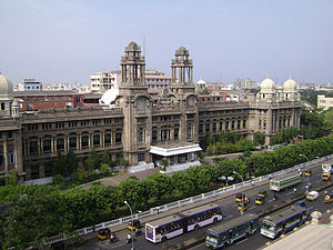
Southern Railway Headquarters, Chennai
Office building in Chennai, India
Distance: Approx. 613 meters
Latitude and longitude: 13.082574,80.277081
Southern Railway headquarters administrative building, Chennai, is an Indo-Saracenic structure located adjacent to the Chennai Central on Poonamallee High Road.
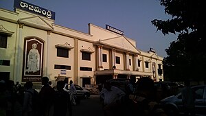
Rajahmundry railway station
Railway station in Andhra Pradesh
Distance: Approx. 711 meters
Latitude and longitude: 13.0825,80.275
Rajahmundry railway station (station code:RJY) located in the Indian state of Andhra Pradesh, serves Rajahmundry in East Godavari district. It is administered under Vijayawada railway division of South Coast Railway zone (formerly South Central Railway zone).
Government Dental Hospital and College, Chennai
Dental wing of the Madras Medical College
Distance: Approx. 613 meters
Latitude and longitude: 13.08333333,80.28166667
Tamil Nadu Government Dental College, also known as Government Dental Hospital and College, is the dental wing of the Madras Medical College. Although the college is a separate entity administratively, it is functionally integrated with the Madras Medical College and Government General Hospital. The hospital is claimed to be the first in the country to provide treatment to 1,000 to 1,500 patients a day in various branches.
Mint Street, Chennai
Historical street in Chennai, India
Distance: Approx. 449 meters
Latitude and longitude: 13.08388889,80.27805556
Mint Street is one of the prime streets of the commercial centre of George Town in Chennai, India. The street is one of the oldest streets in Chennai and is believed to be the longest street in the city. Running north–south, the street connects Poonamallee High Road at Park Town in the south with North Wall Road–Old Jail Road Junction at Washermanpet in the north.
Elephant Gate
Neighbourhood in Chennai district, Tamil Nadu, India
Distance: Approx. 382 meters
Latitude and longitude: 13.09133333,80.27847222
Elephant Gate is a neighbourhood in Chennai district of Tamil Nadu state in the peninsular India. It is located at an altitude of about 33 m above the mean sea level with the geographical coordinates of 13°05′28.8″N 80°16′42.5″E (i.e., 13.091345°N, 80.278475°E). George Town, Royapuram, Kondithope, Mannadi Vannarapettai, Tondiarpet, Sowcarpet, Vallalar Nagar, Basin bridge and Kasimedu are some of the important neighbourhoods of Elephant Gate.
Weather in this IP's area
broken clouds
36 Celsius
43 Celsius
35 Celsius
36 Celsius
1000 hPa
54 %
1000 hPa
998 hPa
6000 meters
5.14 m/s
10.29 m/s
260 degree
75 %
05:53:07
18:37:26