Country:
 France
Region:
City:
Latitude and Longitude:
Time Zone:
Postal Code:
IP information under different IP Channel
ip-api
Country
Region
City
ASN
Time Zone
ISP
Blacklist
Proxy
Latitude
Longitude
Postal
Route
IPinfo
Country
Region
City
ASN
Time Zone
ISP
Blacklist
Proxy
Latitude
Longitude
Postal
Route
MaxMind
Country
Region
City
ASN
Time Zone
ISP
Blacklist
Proxy
Latitude
Longitude
Postal
Route
Luminati
Country
FRRegion
idf
City
paris
ASN
Time Zone
Europe/Paris
ISP
Orange
Latitude
Longitude
Postal
db-ip
Country
Region
City
ASN
Time Zone
ISP
Blacklist
Proxy
Latitude
Longitude
Postal
Route
ipdata
Country
Region
City
ASN
Time Zone
ISP
Blacklist
Proxy
Latitude
Longitude
Postal
Route
Popular places and events near this IP address

Toulouse–Blagnac Airport
International airport in the Occitanie Region, France
Distance: Approx. 2131 meters
Latitude and longitude: 43.635,1.36777778
Toulouse–Blagnac Airport (French: Aéroport de Toulouse–Blagnac) (IATA: TLS, ICAO: LFBO) is an international airport located 3.6 nautical miles (6.7 km; 4.1 mi) west northwest of Toulouse, partially in Blagnac, both communes of the Haute-Garonne department in the Occitanie region of France. In 2017, the airport served 9,264,611 passengers. As of April 2017, the airport features flights to 74 destinations, mostly in Europe and Northern Africa with a few additional seasonal long-haul connections.

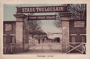
Stade Ernest-Wallon
Rugby stadium in Toulouse, France
Distance: Approx. 2165 meters
Latitude and longitude: 43.62194444,1.41611111
The Stade Ernest-Wallon (French pronunciation: [stad ɛɾnɛ-walõ]; Occitan: Estadi Ernest-Wallon; lit. 'Stadium of Ernest Wallon') is a multi-purpose stadium located in the Sept Deniers district of Toulouse, in southwestern France. Described as a "temple to the oval ball", it is the home ground for the rugby union club Stade Toulousain and the rugby league club Toulouse Olympique.

Blagnac
Commune in Occitania, France
Distance: Approx. 463 meters
Latitude and longitude: 43.6364,1.3906
Blagnac (French pronunciation: [blaɲak]; Occitan: Blanhac) is a commune in the Haute-Garonne department in southwestern France. The city hosts the aviation museum Aeroscopia. It is the third-largest suburb of the city of Toulouse, although governed by a separate council, and is adjacent to it on the northwest side.

Airbus Industrie Flight 129
1994 Aviation accident
Distance: Approx. 2889 meters
Latitude and longitude: 43.635,1.35833333
Airbus Industrie Flight 129 was an Airbus Industrie A330-321 test flight that ended in a crash on 30 June 1994 at Toulouse-Blagnac Airport, killing all seven people aboard. The last test flown was to certify the plane's takeoff capability with a single engine failure. It was the first fatal accident involving an Airbus A330 as well as the first hull loss of the type.
Stade des Ponts Jumeaux
Distance: Approx. 2918 meters
Latitude and longitude: 43.6128,1.417
The Stade des Ponts Jumeaux (the "Twin Bridges Stadium") was a rugby union stadium, inaugurated on 24 November 1907, in the Ponts Jumeaux district of Toulouse, south-western France. The land was purchased by the embryonic Stade Toulousain rugby team – with financial assistance from city notables – then headed by a law professor from the University of Toulouse, Ernest Wallon. The stadium, nicknamed Le Wallon, had a capacity of 6500 and hosted many internationals during its existence.

Touch (river)
River in France
Distance: Approx. 1252 meters
Latitude and longitude: 43.62277778,1.40027778
The Touch (French pronunciation: [tuʃ]; Occitan: Toish) is a 74.5 km (46.3 mi) long river in southwestern France, left tributary of the Garonne. Its source is in the département of Haute-Garonne, near Lilhac. It flows through the following départements and towns: Haute-Garonne: Bérat, Lherm, Plaisance-du-Touch, Tournefeuille, Blagnac, Toulouse.

Stade Ernest-Argelès
French rugby stadium
Distance: Approx. 745 meters
Latitude and longitude: 43.63694444,1.40166667
Ernest-Argelès stadium is a French Rugby football stadium with a capacity of 4,000 seats located in Blagnac (in the close vicinity of Toulouse).
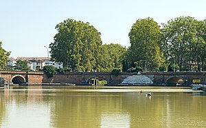
Ponts Jumeaux
Bridge in Toulouse, France
Distance: Approx. 3188 meters
Latitude and longitude: 43.61111111,1.41944444
The Ponts Jumeaux (English: Twin Bridges) is the point at which the Canal du Midi joins the Canal de Garonne and the River Garonne, via the Canal de Brienne. It was built in 1774 by Joseph-Marie de Saget, a civil engineer in the province of Languedoc in Toulouse. In fact, there are three bridges, each of which is the entrance to a canal.

Port de l'Embouchure
Distance: Approx. 3188 meters
Latitude and longitude: 43.61111111,1.41944444
The Port de l'Embouchure (English: Port of Mouth) is one of the two ports located in Toulouse on the Canal du Midi. The other being the Port Saint-Sauveur. This port is located in the basin at the Ponts Jumeaux (English: Twin Bridges).
Canton of Toulouse-2
Distance: Approx. 3312 meters
Latitude and longitude: 43.61,1.42
The canton of Toulouse-2 is an administrative division of the Haute-Garonne department, southern France. Its borders were modified at the French canton reorganisation which came into effect in March 2015. Its seat is in Toulouse.
Canton of Blagnac
Distance: Approx. 478 meters
Latitude and longitude: 43.63,1.39
The canton of Blagnac is an administrative division of the Haute-Garonne department, southern France. Its borders were modified at the French canton reorganisation which came into effect in March 2015. Its seat is in Blagnac.

Hôpital de Purpan
Hospital in Occitanie, France
Distance: Approx. 2719 meters
Latitude and longitude: 43.6091822,1.4009266
The Hôpital de Purpan is a public health establishment located in France in Toulouse Haute-Garonne district of Purpan. It is part of the Centre hospitalier universitaire de Toulouse.
Weather in this IP's area
clear sky
20 Celsius
20 Celsius
19 Celsius
20 Celsius
1013 hPa
88 %
1013 hPa
997 hPa
10000 meters
2.06 m/s
290 degree
06:38:28
21:23:09