Country:
 Great Britain
Region:
City:
Latitude and Longitude:
Time Zone:
Postal Code:
IP information under different IP Channel
ip-api
Country
Region
City
ASN
Time Zone
ISP
Blacklist
Proxy
Latitude
Longitude
Postal
Route
IPinfo
Country
Region
City
ASN
Time Zone
ISP
Blacklist
Proxy
Latitude
Longitude
Postal
Route
MaxMind
Country
Region
City
ASN
Time Zone
ISP
Blacklist
Proxy
Latitude
Longitude
Postal
Route
Luminati
Country
GBRegion
eng
City
greenwich
ASN
Time Zone
Europe/London
ISP
GTT Communications Inc.
Latitude
Longitude
Postal
db-ip
Country
Region
City
ASN
Time Zone
ISP
Blacklist
Proxy
Latitude
Longitude
Postal
Route
ipdata
Country
Region
City
ASN
Time Zone
ISP
Blacklist
Proxy
Latitude
Longitude
Postal
Route
Popular places and events near this IP address

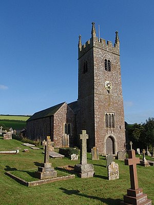
Bishopsteignton
Village in Devon, England
Distance: Approx. 3310 meters
Latitude and longitude: 50.554,-3.542
Bishopsteignton is a village and civil parish in South Devon, England, between Newton Abbot and Teignmouth, close to the Teign Estuary. The village is on a steep hill, and has a post office and pharmacy and a small, family-run village shop. The village school has about 180 pupils.

Ashcombe
Village in Devon, England
Distance: Approx. 1989 meters
Latitude and longitude: 50.6,-3.54
Ashcombe is a village and civil parish in the Teignbridge district of Devon, England, about eight miles south of the city of Exeter. The parish is surrounded clockwise from the north by the parishes of Kenton, Mamhead, Dawlish, Bishopsteignton and Chudleigh. In 2001 its population was 77, down from 125 in 1901.
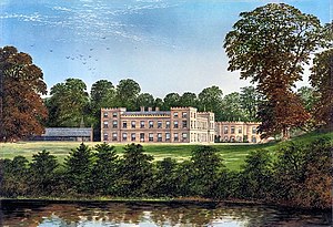
Ugbrooke
Country house in Devon, England
Distance: Approx. 2995 meters
Latitude and longitude: 50.59086,-3.59067
Ugbrooke House is a stately home in the parish of Chudleigh, Devon, England, situated in a valley between Exeter and Newton Abbot. The home of the Clifford family, the house and grounds are available for guided tours in summer and as an event venue.
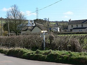
Luton, Teignbridge
Village in Devon, England
Distance: Approx. 257 meters
Latitude and longitude: 50.581424,-3.552122
Luton is a village in Devon, England, within Teignbridge local authority area. Historically Luton formed part of Ashcombe Hundred. The village is in the parish of Bishopsteignton, but has a chapel of ease, dedicated to St John the Evangelist, built in the 19th century.
Ashwell, Devon
Village in Devon, England
Distance: Approx. 2718 meters
Latitude and longitude: 50.5591,-3.5551
Ashwell is a village in Devon, England.
Olchard
Village in Devon, England
Distance: Approx. 2851 meters
Latitude and longitude: 50.58,-3.59
Olchard is a village in Devon, England.

Castle Dyke
Iron Age hill fort in Devon, England
Distance: Approx. 1776 meters
Latitude and longitude: 50.5826,-3.5249
Castle Dyke is an Iron Age hill fort situated between Chudleigh and Dawlish in Devon, England. The fort is situated on a hilltop at approximately 140 metres above sea level.

Lindridge House
Demolished mansion in Devon, England
Distance: Approx. 1494 meters
Latitude and longitude: 50.5711,-3.5588
Lindridge House was a large 17th-century mansion (with 20th-century alterations), one of the finest in the south-west situated about 1 mile south of Ideford in the parish of Bishopsteignton, Devon, about 4 1/2 miles NE of Newton Abbot. It was destroyed by fire on 25 April 1963 and its ruins were finally demolished in the early 1990s, upon which was built a housing development. The gardens have been restored and are Grade II listed in the National Register of Historic Parks and Gardens.

Ideford Common
Distance: Approx. 1476 meters
Latitude and longitude: 50.596,-3.556
Ideford Common is a Site of Special Scientific Interest consisting of an area of lowland heath in Devon, England. The site is a habitat for nightjars and Dartford warblers, and is the site of several Bronze Age cairns and a barrow. Ideford and Haldon Forest are nearby.
Ideford
Village in Devon, England
Distance: Approx. 1178 meters
Latitude and longitude: 50.58333333,-3.56666667
Ideford (or Ideford Parish) is a village in the Teignbridge district of Devon, England. It is 5 miles (8 km) north of Newton Abbot. To the west is the A380 dual carriageway and to the east are Luton and Teignmouth Golf Club.
Haldon Aerodrome
Defunct airfield in England
Distance: Approx. 1606 meters
Latitude and longitude: 50.57555556,-3.53083333
Haldon Aerodrome was the first airfield in Devon.
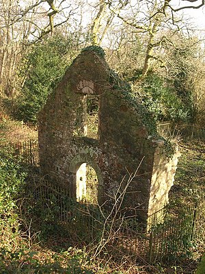
Lidwell Chapel
Medieval chapel in England
Distance: Approx. 2282 meters
Latitude and longitude: 50.574781,-3.520642
Lidwell Chapel, also known as St Mary's Chapel, is a medieval chapel, now in ruins, within the parish of Dawlish in Devon, England. The chapel is a Grade II listed building, and was first listed in 1951.
Weather in this IP's area
clear sky
18 Celsius
18 Celsius
17 Celsius
20 Celsius
1015 hPa
76 %
1015 hPa
1002 hPa
10000 meters
4.16 m/s
5.29 m/s
242 degree
7 %
05:34:42
21:06:28