Country:
 Great Britain
Region:
City:
Latitude and Longitude:
Time Zone:
Postal Code:
IP information under different IP Channel
ip-api
Country
Region
City
ASN
Time Zone
ISP
Blacklist
Proxy
Latitude
Longitude
Postal
Route
IPinfo
Country
Region
City
ASN
Time Zone
ISP
Blacklist
Proxy
Latitude
Longitude
Postal
Route
MaxMind
Country
Region
City
ASN
Time Zone
ISP
Blacklist
Proxy
Latitude
Longitude
Postal
Route
Luminati
Country
GBASN
Time Zone
Europe/London
ISP
PRT Systems Limited
Latitude
Longitude
Postal
db-ip
Country
Region
City
ASN
Time Zone
ISP
Blacklist
Proxy
Latitude
Longitude
Postal
Route
ipdata
Country
Region
City
ASN
Time Zone
ISP
Blacklist
Proxy
Latitude
Longitude
Postal
Route
Popular places and events near this IP address
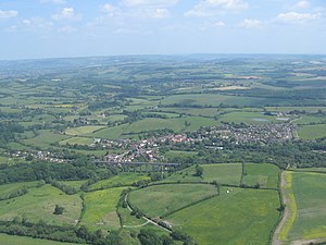
Pensford
Human settlement in England
Distance: Approx. 2207 meters
Latitude and longitude: 51.371,-2.5466
Pensford is the largest village in the civil parish of Publow in Somerset, England. It lies in the Chew Valley, approximately 7 miles (11 km) south of Bristol, 8 miles (13 km) west of Bath, and 14 miles (23 km) north of Wells. It is on the A37 road from Bristol to Shepton Mallet.
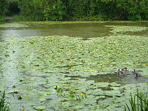
Hunstrete Lake
Distance: Approx. 1209 meters
Latitude and longitude: 51.35776,-2.50979
Hunstrete Lake (grid reference ST646622) is a mature lake of 5 acres (20,000 m2). Two new lakes of 3.5 acres (14,000 m2) were constructed alongside in the 1990s. They are situated just to the south of the village of Hunstrete, Somerset; south of Bristol, and 7 miles (11 km) west of Bath.

Lord's Wood, Pensford
Woodland in Bristol, United Kingdom
Distance: Approx. 1089 meters
Latitude and longitude: 51.36527778,-2.52694444
Lord's Wood is a woodland southeast of the village of Pensford in the Chew Valley, south of Bristol, England. The wood largely consists of planted conifers, however some broad-leaved areas remain. A number of small streams flow northward through the wood, converging and then eventually meeting the River Chew to the north.

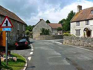
Chelwood
Human settlement in England
Distance: Approx. 148 meters
Latitude and longitude: 51.3549,-2.5249
Chelwood is a small village and civil parish in Somerset, England, and is in the affluent Chew Valley in the Bath and North East Somerset council area, about 8 miles (13 km) from Bristol and Bath. The parish, which includes the hamlets of West Chelwood and Breach, has a population of 148. It is situated on the A368 (Bath to Weston-super-Mare road) between Marksbury and Bishop Sutton, very close to the A37.
Woollard
Human settlement in England
Distance: Approx. 2678 meters
Latitude and longitude: 51.3792,-2.5334
Woollard is a small village on the River Chew in the affluent Chew Valley in England. It is in the Bath and North East Somerset council area and the ceremonial county of Somerset. The village is 7 miles (11 km) from Bristol, 9 miles (14 km) from Bath, and 4 miles (6.4 km) from Keynsham.

Hunstrete
Human settlement in England
Distance: Approx. 1465 meters
Latitude and longitude: 51.36,-2.507
Hunstrete (grid reference ST625643) is a small village on the River Chew in the Chew Valley, Bath and North East Somerset, England. It falls within the civil parish of Marksbury and is 8 miles (13 km) from Bath and Bristol, and 5 miles (8 km) from Keynsham. It is just off the A368 between Marksbury and Chelwood.

St Thomas à Becket Church, Pensford
Church in Somerset, England
Distance: Approx. 2354 meters
Latitude and longitude: 51.371025,-2.549796
St Thomas à Becket Church in Pensford, Somerset southwest England, dates from the 14th century, active in 1341, although only the tower remains from that date, the rest of the church having been rebuilt in 1868 by Giles and Robinson Architects and the church was reconsecrated in 1869. The church became derelict as a result of flood damage caused by the River Chew in 1968. It remained in disuse until 2008.

Church of All Saints, Publow
Church in Somerset, England
Distance: Approx. 2532 meters
Latitude and longitude: 51.37611111,-2.54222222
The Church of All Saints in Publow, Somerset, England, dates from the 14th century has a 15th-century tower with gargoyles. The pulpit is Jacobean. It has been designated a Grade I listed building.

Church of St Leonard, Chelwood
Church in Somerset, England
Distance: Approx. 811 meters
Latitude and longitude: 51.36277778,-2.52722222
The Church of St Leonard is a redundant church in Chelwood, Somerset, England. It was built in the 14th century and has been designated as a Grade II* listed building. The church was largely rebuilt during restoration around 1860.

Pensford Viaduct
Bridge in Somerset, England
Distance: Approx. 2418 meters
Latitude and longitude: 51.3708,-2.5515
Pensford Viaduct is a disused railway bridge in the village of Pensford, within the historic English county of Somerset, now unitary authority Bath and North East Somerset. It is a Grade II listed building.
Chew Valley Brewery
Distance: Approx. 1971 meters
Latitude and longitude: 51.3678,-2.5472
The Chew Valley Brewery is a microbrewery based in Pensford, Somerset, England. The brewery was opened in 2014 by Dom Lowe and Matt Stalker, after training at Masters Brewery in Wellington. The company logo uses an illustration of the Pensford Viaduct.

Pensford railway station
Disused railway station in Pensford, Somerset
Distance: Approx. 2631 meters
Latitude and longitude: 51.3733,-2.5517
Pensford railway station served the village of Pensford, Somerset, England from 1873 to 1964 on the Bristol and North Somerset Railway.
Weather in this IP's area
clear sky
11 Celsius
11 Celsius
10 Celsius
13 Celsius
1014 hPa
92 %
1014 hPa
1003 hPa
10000 meters
1.72 m/s
2.8 m/s
216 degree
7 %
05:27:29
21:05:30