Country:
 Ukraine
Region:
City:
Latitude and Longitude:
Time Zone:
Postal Code:
IP information under different IP Channel
ip-api
Country
Region
City
ASN
Time Zone
ISP
Blacklist
Proxy
Latitude
Longitude
Postal
Route
IPinfo
Country
Region
City
ASN
Time Zone
ISP
Blacklist
Proxy
Latitude
Longitude
Postal
Route
MaxMind
Country
Region
City
ASN
Time Zone
ISP
Blacklist
Proxy
Latitude
Longitude
Postal
Route
Luminati
Country
UARegion
59
City
sumy
ASN
Time Zone
Europe/Kyiv
ISP
Technical Centre Radio Systems Ltd.
Latitude
Longitude
Postal
db-ip
Country
Region
City
ASN
Time Zone
ISP
Blacklist
Proxy
Latitude
Longitude
Postal
Route
ipdata
Country
Region
City
ASN
Time Zone
ISP
Blacklist
Proxy
Latitude
Longitude
Postal
Route
Popular places and events near this IP address
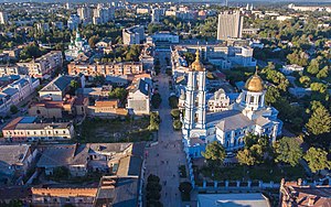
Sumy
City and administrative center of Sumy Oblast, Ukraine
Distance: Approx. 1116 meters
Latitude and longitude: 50.91194444,34.80277778
Sumy (Ukrainian: Суми, IPA: [ˈsumɪ] ) is a city in northeastern Ukraine. It serves as the administrative center of Sumy Oblast. The city is situated on the banks of the Psel River with a population of 256,474 (2022 estimate), making it the 23rd-largest in the country.
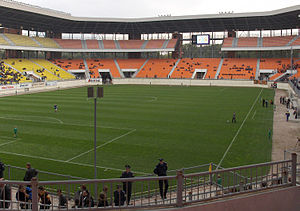
Yuvileiny Stadium
Football stadium in Sumy, Ukraine
Distance: Approx. 2169 meters
Latitude and longitude: 50.90222222,34.79972222
Yuvileiny Stadium is a football stadium in Sumy, Ukraine. It serves as home grounds for Ukrainian First League club FC Viktoriya Sumy, and as a secondary venue for Ukrainian Second League club FC Sumy, whose main field is Avangarde Stadium. With a capacity of 25,830 spectators, it is the 7th largest stadium in Ukraine.
Sumy Airport
Airport in Sumy Oblast, Ukraine
Distance: Approx. 7508 meters
Latitude and longitude: 50.85833333,34.7625
Sumy Airport (IATA: UMY, ICAO: UKHS) is a state international airport located in Sumy, Ukraine. It has become international since 8 December 2006. The airport is capable of accepting such aircraft as the Tu-134 (with limitations), An-24, Yak-40, and aircraft of lower classes round-the-clock.

Nikanor Onatsky Regional Art Museum in Sumy
Distance: Approx. 1736 meters
Latitude and longitude: 50.90611111,34.79944444
Nikanor Onatsky Regional Art Museum in Sumy is a state museum in Sumy, Ukraine. Its collection is one of the best in Ukraine and contains works of native and from all over the world artists. It is a real treasure trove of national and foreign fine and decorative arts of the XVI - XXI centuries, based on the art collection of the famous Kyiv industrialist and philanthropist Oskar Hansen.

Sumy State University
Public university in Sumy, Ukraine
Distance: Approx. 4438 meters
Latitude and longitude: 50.89222222,34.84166667
Sumy State University (SumDU) is a higher educational institution in Sumy, Ukraine. It enrolls about 12,000 students pursuing pre-undergraduate, undergraduate, specialist, and master degrees in 55 majors and 23 fields. About 1,900 foreign students represent almost 50 countries worldwide.
Institute of Applied Physics, National Academy of Sciences of Ukraine
Distance: Approx. 1823 meters
Latitude and longitude: 50.90555,34.79479
The Institute of Applied Physics, National Academy of Sciences of Ukraine, was established by the Decree of the Presidium of NAS Ukraine from 21.11.1991 No. 299 on the base of the Sumy branch of the Institute of Metallophysics to enlarge the fundamental and applied investigations in nuclear technology. The initiative belongs to Volodymyr Yu.

Scientific library of the Ukrainian Academy of Banking
Distance: Approx. 1815 meters
Latitude and longitude: 50.905563,34.795439
The Scientific library of the Ukrainian Academy of Banking is a library in Sumy, Ukraine that is associated with the National Bank of Ukraine.

Sumy National Agrarian University
Public university in Sumy, Ukraine
Distance: Approx. 4519 meters
Latitude and longitude: 50.88333333,34.77805556
Sumy National Agrarian University (SNAU) is a higher educational institution, located in Sumy, Ukraine.

Michael's Virgin Land Nature Reserve
Nature reserve in Ukraine
Distance: Approx. 3491 meters
Latitude and longitude: 50.91666667,34.75
Michael's Virgin Land Nature Reserve (Ukrainian: Михайлівська цілина) is a protected nature reserve of Ukraine that covers meadow-steppe and forest-steppe in the northeast of Ukraine near the border with Russia. It exhibits plants found in both northern and southern steppes. First created as a reserve in 1928, it was expanded over the years and formally upgraded to a national reserve in 2009.
Stare Selo, Sumy Oblast
Urban locality in Sumy Oblast, Ukraine
Distance: Approx. 3491 meters
Latitude and longitude: 50.91666667,34.75
Stare Selo (Ukrainian: Старе Село), literally "Old Village", until 2016 – Chervone (Ukrainian: Червоне), or simply Stare, is a village in Ukraine, in Sumy Raion, Sumy Oblast. It is the seat of its local self-governing body, Starosiljskiy Village Council.
Sumy urban hromada
Urban hromada of Sumy Oblast, Ukraine
Distance: Approx. 1116 meters
Latitude and longitude: 50.91194444,34.80277778
Sumy urban territorial hromada (Ukrainian: Сумська міська територіальна громада, romanized: Sumska miska terytorialna hromada) is one of Ukraine's hromadas. It is located in Sumy Raion, Sumy Oblast, and its administrative centre is the city of Sumy. The hromada has an area of 349.0 km2 (134.7 sq mi), as well as a population of 279,620 (as of 2023).

Sad, Sumy Oblast
Village in Sumy Oblast, Ukraine
Distance: Approx. 7297 meters
Latitude and longitude: 50.88416667,34.71388889
Sad (Ukrainian: Сад, lit. 'garden'), known from January to February 1977 as Doslidna (Ukrainian: Дослідна, lit. 'experimental'), is a village in Sumy Raion, within Ukraine's central Sumy Oblast. It is the capital of the Sad rural hromada, one of the hromadas of Ukraine. Its population is 2,348 (as of 2024).
Weather in this IP's area
overcast clouds
24 Celsius
24 Celsius
24 Celsius
24 Celsius
1016 hPa
34 %
1016 hPa
1000 hPa
10000 meters
1.21 m/s
1.1 m/s
32 degree
95 %
04:59:48
20:34:34