Country:
 USA
USARegion:
City:
Latitude and Longitude:
Time Zone:
Postal Code:
IP information under different IP Channel
ip-api
Country
Region
City
ASN
Time Zone
ISP
Blacklist
Proxy
Latitude
Longitude
Postal
Route
IPinfo
Country
Region
City
ASN
Time Zone
ISP
Blacklist
Proxy
Latitude
Longitude
Postal
Route
MaxMind
Country
Region
City
ASN
Time Zone
ISP
Blacklist
Proxy
Latitude
Longitude
Postal
Route
Luminati
Country
USRegion
in
City
indianapolis
ASN
Time Zone
America/Indiana/Indianapolis
ISP
LILLY-AS
Latitude
Longitude
Postal
db-ip
Country
Region
City
ASN
Time Zone
ISP
Blacklist
Proxy
Latitude
Longitude
Postal
Route
ipdata
Country
Region
City
ASN
Time Zone
ISP
Blacklist
Proxy
Latitude
Longitude
Postal
Route
Popular places and events near this IP address

Lucas Oil Stadium
American football stadium in Indianapolis, Indiana, U.S.
Distance: Approx. 1806 meters
Latitude and longitude: 39.76005556,-86.16380556
Lucas Oil Stadium is a multi-purpose stadium in downtown Indianapolis, Indiana, United States. It replaced the RCA Dome as the home field of the National Football League (NFL)'s Indianapolis Colts and opened on August 16, 2008. The stadium was constructed to allow the removal of the RCA Dome and expansion of the Indiana Convention Center on its site.
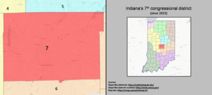
Indiana's 7th congressional district
U.S. House district for Indiana
Distance: Approx. 1224 meters
Latitude and longitude: 39.75,-86.15
Indiana's 7th congressional district is a congressional district in the U.S. state of Indiana. It is entirely located within Marion County and includes most of Indianapolis, except for the southern side, which is located within the 6th district. The district is currently represented by Democrat André Carson, who won a special election in 2008 to succeed his grandmother Julia Carson following her death in 2007.
Indiana's 10th congressional district
Former U.S. House district from 1843 to 2003
Distance: Approx. 1224 meters
Latitude and longitude: 39.75,-86.15
Indiana's 10th congressional district was a congressional district for the United States House of Representatives in Indiana. It encompassed roughly the "Old City Limits" of Indianapolis from 1983 to 2003. The district was re-drawn after the 1980 census and eliminated when Indiana's representation in the House of Representatives fell from ten to nine after the 2000 census.
Bates–Hendricks
Neighborhood in Indianapolis, Indiana, U.S.
Distance: Approx. 1321 meters
Latitude and longitude: 39.747,-86.147
The Bates–Hendricks neighborhood is situated just south and east of the downtown commercial district of Indianapolis, Indiana. The Fountain Square business district is just to the east. Access to the neighborhood from the north is by way of East Street, while Terrace Street off of Madison Avenue enters the neighborhood from the west and Prospect Street offers access from Fountain Square.
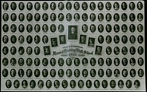
Emmerich Manual High School
Public high school in Indianapolis, Marion County, Indiana, United States
Distance: Approx. 1399 meters
Latitude and longitude: 39.73333333,-86.15305556
Emmerich Manual High School, often referred to as Manual High School, is a public high school in Indianapolis, Indiana, United States. It formerly was a traditional high school in the Indianapolis Public Schools (IPS) district. It is now one of the schools operated by Christel House Academy and is named Christel House High School.

Pogue's Run
Waterway in Marion County, Indiana, U.S.
Distance: Approx. 1631 meters
Latitude and longitude: 39.75619,-86.17228
Pogue's Run is an urban creek that starts near the intersection of Elizabeth Street and Lennington Drive on the east side of Indianapolis, Indiana, and empties into the White River south of the Kentucky Avenue bridge over that river. At the stream's intersection with New York Street just east of downtown Indianapolis it enters a double-box culvert conduit through which it flows underneath downtown Indianapolis. It is named for George Pogue, who, along with John Wesley McCormick, were among the first settlers in what would become the city of Indianapolis.
Play (Jonker)
Distance: Approx. 1025 meters
Latitude and longitude: 39.75080278,-86.15397778
Play is an abstract sculpture by Lars Jonker. It is located in Hendricks Park, in the historic Bates-Hendricks neighborhood, south of downtown Indianapolis, Indiana.
Fountain Square Academy
Charter school in Indianapolis, Indiana, United States
Distance: Approx. 1823 meters
Latitude and longitude: 39.745773,-86.140747
Fountain Square Academy was a free public charter school for grades 6–12 in Indianapolis, Indiana. It offered a "Middle College" program that allowed qualifying high school students to take college courses for college credit at Ivy Tech Community College at no additional cost while still enrolled in high school. The school was closed after the 2011–2012 school year when Greg Ballard, the mayor of Indianapolis, declined, in March 2011, to renew its charter due to lack of academic progress.
Indianapolis Colts Ring of Honor
Team hall of fame
Distance: Approx. 1806 meters
Latitude and longitude: 39.76005556,-86.16380556
The Indianapolis Colts Ring of Honor honors former players, coaches, club officials, and fans who made outstanding contributions to the Indianapolis Colts football organization. Originally a ring around the former RCA Dome in Indianapolis, Indiana, it currently encircles Lucas Oil Stadium. The Ring of Honor began on September 23, 1996, with the induction of then owner, Robert Irsay.

Horace Mann Public School No. 13
United States historic place
Distance: Approx. 1752 meters
Latitude and longitude: 39.75416667,-86.14638889
Horace Mann Public School No. 13 is a historic school building located at Indianapolis, Indiana. It was designed by architect Edwin May (1823–1880) and built in 1873.

South Side Turnverein Hall
Historic structure in Indianapolis, Indiana
Distance: Approx. 1206 meters
Latitude and longitude: 39.7525,-86.15333333
South Side Turnverein Hall is a historic social club and gymnasium in the Bates-Hendricks neighborhood of Indianapolis, Indiana, affiliated with the city's German-American community. It was built in 1900 by prominent architects Vonnegut & Bohn, whose managing partners Bernard Vonnegut, Sr. and Arthur Bohn were members of the burgeoning German-American community in Indianapolis.

10th National Eucharistic Congress (United States)
2024 Catholic event in Indiana, US
Distance: Approx. 1806 meters
Latitude and longitude: 39.76005556,-86.16380556
The Tenth National Eucharistic Congress was held July 17–21, 2024 (2024-07-17 – 2024-07-21), at Lucas Oil Stadium and the Indiana Convention Center in Indianapolis, Indiana, to foster devotion to the sacrament of the Eucharist. It was organized by the United States Conference of Catholic Bishops.
Weather in this IP's area
clear sky
15 Celsius
15 Celsius
14 Celsius
17 Celsius
1020 hPa
90 %
1020 hPa
994 hPa
10000 meters
1.88 m/s
3.97 m/s
107 degree
06:39:28
21:02:35