Country:
 South Africa
Region:
City:
Latitude and Longitude:
Time Zone:
Postal Code:
IP information under different IP Channel
ip-api
Country
Region
City
ASN
Time Zone
ISP
Blacklist
Proxy
Latitude
Longitude
Postal
Route
IPinfo
Country
Region
City
ASN
Time Zone
ISP
Blacklist
Proxy
Latitude
Longitude
Postal
Route
MaxMind
Country
Region
City
ASN
Time Zone
ISP
Blacklist
Proxy
Latitude
Longitude
Postal
Route
Luminati
Country
ZAASN
Time Zone
Africa/Johannesburg
Latitude
Longitude
Postal
db-ip
Country
Region
City
ASN
Time Zone
ISP
Blacklist
Proxy
Latitude
Longitude
Postal
Route
ipdata
Country
Region
City
ASN
Time Zone
ISP
Blacklist
Proxy
Latitude
Longitude
Postal
Route
Popular places and events near this IP address

Pretoria
Administrative capital of South Africa
Distance: Approx. 136 meters
Latitude and longitude: -25.74611111,28.18805556
Pretoria ( prih-TOR-ee-ə, pree-; Afrikaans: [prəˈtʊəria] ), is South Africa's administrative capital, serving as the seat of the executive branch of government, and as the host to all foreign embassies to South Africa. Pretoria straddles the Apies River and extends eastward into the foothills of the Magaliesberg mountains. It has a reputation as an academic city and center of research, being home to the Tshwane University of Technology (TUT), the University of Pretoria (UP), the University of South Africa (UNISA), the Council for Scientific and Industrial Research (CSIR), and the Human Sciences Research Council.
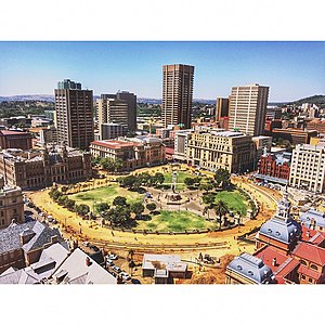
Church Square, Pretoria
Square at the historic centre of Pretoria
Distance: Approx. 181 meters
Latitude and longitude: -25.7465,28.1882
Church Square (Afrikaans: Kerkplein), originally Market Square (Dutch: Marktplein), is the square at the historic centre of the city of Pretoria, Gauteng, South Africa. The founder of Pretoria, Marthinus Pretorius, determined that the square be used as a market place and church yard. It was subsequently named for the church buildings that stood at the centre of the square from 1856 to 1905.

Church Street, Pretoria bombing
Car bomb attack
Distance: Approx. 314 meters
Latitude and longitude: -25.74638889,28.19055556
The Church Street bombing was a car bomb attack on 20 May 1983 in the South African capital Pretoria by uMkhonto we Sizwe (MK), the paramilitary wing of the African National Congress. The bombing killed 19 people, including the two perpetrators, and wounded 217.
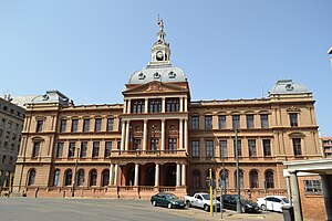
Ou Raadsaal
Historic parliament building in Pretoria, South Africa
Distance: Approx. 259 meters
Latitude and longitude: -25.74722222,28.18777778
The Ou Raadsaal (English: Old Council Hall) is a historic building in Pretoria, South Africa, located on the south side of Church Square. The Ou Raadsaal housed the Volksraad, the parliament of the South African Republic, from 1891 to 1902. The Ou Raadsaal was commissioned in the late 19th century by the South African Republic as the new seat of government in Pretoria, and was designed by Dutch architect Sytze Wierda in a Renaissance Revival style.
Palace of Justice, Pretoria
Historic courthouse in Pretoria, South Africa
Distance: Approx. 290 meters
Latitude and longitude: -25.7475,28.1878
[[Image:Law Chambers-011.jpg |thumb|right|300px|The Palace of Justice on Church Square in Pretoria]] The Palace of Justice forms part of the northern façade of Church Square in Pretoria. The building dates to the nineteenth century and was designed by the Dutch architect Sytze Wierda. It is currently the headquarters of the Gauteng Division of the High Court of South Africa.

Gauteng Division
Superior court of law in Gauteng, South Africa
Distance: Approx. 60 meters
Latitude and longitude: -25.7446,28.1874
The Gauteng Division of the High Court of South Africa is a superior court of law which has general jurisdiction over the South African province of Gauteng and the eastern part of North West province. The main seat of the division is at Pretoria, while a local seat at Johannesburg has concurrent jurisdiction over the southern parts of Gauteng. Dunstan Mlambo has been the Judge President of the division since 1 November 2012.

Statue of Paul Kruger, Church Square
Bronze sculpture in Pretoria, South Africa
Distance: Approx. 173 meters
Latitude and longitude: -25.74645,28.18806
The Statue of Paul Kruger (Afrikaans: Krugerstandbeeld) is a bronze sculpture located in Church Square in Pretoria, South Africa. The statue depicts Paul Kruger, the Boer political and military leader and President of the South African Republic from 1883 to 1900, and four unnamed Boer soldiers. The Statue of Paul Kruger was sculpted in 1896 and was installed in its current location in Church Square in 1954.
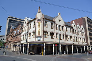
Café Riche, Pretoria
Distance: Approx. 210 meters
Latitude and longitude: -25.74669,28.18724
Café Riche is on the corner of Parliament and WF Nkomo (f. Church) Streets, adjoining Church Square, Pretoria, South Africa. The building was designed by the Dutch architect Frans Soff and built in 1905.

Old Netherlands Bank building
Distance: Approx. 249 meters
Latitude and longitude: -25.74703889,28.18718333
The Old Netherlands Bank building (Afrikaans: Ou Nederlandse Bankgebou, Dutch: Oude Nederlandsche Bankgebouw) is a building on Church Square in the South African administrative capital of Pretoria. The building carries the name of the former Nederlandsche Bank voor Suid-Afrika (now Nedbank) and is one of the protected buildings on the western side of the Square.
Magalieskruin
Place in Gauteng, South Africa
Distance: Approx. 136 meters
Latitude and longitude: -25.74611111,28.18805556
Magalieskruin is a suburb located in the northern part of Pretoria. The suburb is mostly located on the Magaliesberg and entirely south of Sefako Makgato Drive (R513). It is bordered by Montana Park to the east and Wonderboom to the west.
Queenswood
Place in Gauteng, South Africa
Distance: Approx. 136 meters
Latitude and longitude: -25.74611111,28.18805556
Queenswood is a suburb in the northeast of Pretoria in Gauteng, South Africa. It is bordered by Villieria to the north and Hatfield to the south. Queenswood is home to Laerskool Queenswood.

Old Synagogue, Pretoria
Distance: Approx. 258 meters
Latitude and longitude: -25.742589,28.188022
The Old Synagogue is a former synagogue and apartheid-era court on Paul Kruger Street in Pretoria. It was consecrated in 1898 and closed as a synagogue in 1952, when the congregation moved to a larger site. It was subsequently expropriated and sold to the State for use as a Special Annex of the Supreme Court of South Africa between 1956–1977.
Weather in this IP's area
few clouds
6 Celsius
6 Celsius
5 Celsius
6 Celsius
1018 hPa
70 %
1018 hPa
869 hPa
10000 meters
1.03 m/s
150 degree
13 %
06:48:12
17:39:04