Country:
 USA
USARegion:
City:
Latitude and Longitude:
Time Zone:
Postal Code:
IP information under different IP Channel
ip-api
Country
Region
City
ASN
Time Zone
ISP
Blacklist
Proxy
Latitude
Longitude
Postal
Route
IPinfo
Country
Region
City
ASN
Time Zone
ISP
Blacklist
Proxy
Latitude
Longitude
Postal
Route
MaxMind
Country
Region
City
ASN
Time Zone
ISP
Blacklist
Proxy
Latitude
Longitude
Postal
Route
Luminati
Country
USASN
Time Zone
America/Chicago
Latitude
Longitude
Postal
db-ip
Country
Region
City
ASN
Time Zone
ISP
Blacklist
Proxy
Latitude
Longitude
Postal
Route
ipdata
Country
Region
City
ASN
Time Zone
ISP
Blacklist
Proxy
Latitude
Longitude
Postal
Route
Popular places and events near this IP address

Woodbridge (CDP), New Jersey
Populated place in Middlesex County, New Jersey, US
Distance: Approx. 272 meters
Latitude and longitude: 40.554981,-74.285014
Woodbridge is an unincorporated community and census-designated place (CDP) within Woodbridge Township, in Middlesex County, in the U.S. state of New Jersey. As of the 2010 United States Census, the CDP's population was 19,265. Despite the similarity in the name of the CDP and the township, the two are not coextensive; the CDP occupies 15.7% of the township's 24.51 square miles (63.5 km2).

Woodbridge Township, New Jersey
Township in Middlesex County, New Jersey, US
Distance: Approx. 478 meters
Latitude and longitude: 40.56,-74.29
Woodbridge Township is a township in northern Middlesex County, in the U.S. state of New Jersey. The township is a regional hub of transportation and commerce for central New Jersey and a major bedroom suburb of New York City, within the New York metropolitan area. Located within the core of the Raritan Valley region, Woodbridge Township hosts the junction of the New Jersey Turnpike and the Garden State Parkway, the two busiest highways in the state, and also serves as the headquarters for the New Jersey Turnpike Authority, which operates both highways.
Woodbridge High School (New Jersey)
High school in Middlesex County, New Jersey, US
Distance: Approx. 1010 meters
Latitude and longitude: 40.566448,-74.284695
Woodbridge High School is a four-year comprehensive public high school located in Woodbridge Township, in Middlesex County, New Jersey, serving students in ninth through twelfth grades as part of the Woodbridge Township School District. The high school is one of three in the district, together with Colonia High School and John F. Kennedy Memorial High School. The school has been accredited by the Middle States Association of Colleges and Schools Commission on Elementary and Secondary Schools since 1928.
Woodbridge Township School District
School district in Middlesex County, New Jersey, US
Distance: Approx. 505 meters
Latitude and longitude: 40.55521,-74.280274
The Woodbridge Township School District is a comprehensive community public school district that serves students in pre-kindergarten through twelfth grade from Woodbridge Township in Middlesex County, in the U.S. state of New Jersey. All schools are accredited by the Middle States Association of Colleges and Schools. As of the 2022–23 school year, the district, comprising 25 schools, had an enrollment of 13,836 students and 1,193.7 classroom teachers (on an FTE basis), for a student–teacher ratio of 11.6:1.

Woodbridge station (NJ Transit)
NJ Transit rail station
Distance: Approx. 654 meters
Latitude and longitude: 40.55709444,-74.27778333
Woodbridge is a commuter railroad station in Woodbridge Township, Middlesex County, New Jersey, United States. Located on NJ Transit's North Jersey Coast Line, it is one of three active railroad stations in the eponymous township, including Avenel to the north on the same line and Metropark station on the Northeast Corridor Line. Woodbridge station is located on Pearl Street at the intersection with Brook Street, where stairs to the single island platform that serves trains are located.

Woodbridge Center
Shopping mall in Middlesex County, New Jersey, US
Distance: Approx. 1163 meters
Latitude and longitude: 40.556666,-74.299213
Woodbridge Center is a major two-level shopping mall located in Woodbridge Township, in the U.S. state of New Jersey, at the intersection of U.S. Route 1 and U.S. Route 9. As of 2022, the mall features Macy's, Boscov's, J. C. Penney, and Dick's Sporting Goods. The land that Woodbridge Center now stands on used to be the location of Maple Hill Dairy farm and old clay pits.
St. James Catholic Church (Woodbridge, New Jersey)
Church in New Jersey, United States
Distance: Approx. 592 meters
Latitude and longitude: 40.552882,-74.281815
St. James Catholic Church is located in Woodbridge, New Jersey. With approximately 4,000 registered families, St.

First Presbyterian Church and Cemetery
Historic church in New Jersey, United States
Distance: Approx. 1133 meters
Latitude and longitude: 40.56166667,-74.27333333
The First Presbyterian Church is located at 600 Rahway Avenue in Woodbridge Township of Middlesex County, New Jersey, United States. The congregation was founded in 1675. The main part of the church building was completed in 1803.

Trinity Episcopal Church (Woodbridge, New Jersey)
Historic church in New Jersey, United States
Distance: Approx. 1168 meters
Latitude and longitude: 40.56194444,-74.27305556
Trinity Episcopal Church is a historic church located at 650 Rahway Avenue in Woodbridge Township of Middlesex County, New Jersey. The third church at this location, it was added to the National Register of Historic Places on May 12, 2004, for its significance in architecture and religion.
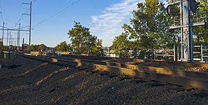
Woodbridge train derailment
1951 public transit accident in New Jersey, U.S.
Distance: Approx. 990 meters
Latitude and longitude: 40.5518,-74.2764
On February 6, 1951, a Pennsylvania Railroad train derailed on a temporary wooden trestle in Woodbridge, New Jersey, United States, killing 85 passengers. It remains New Jersey's deadliest train wreck, the deadliest U.S. derailment since 1918 and the deadliest peacetime rail disaster in the U.S. history. Around 5:00 pm.
Congregation Adath Israel (Woodbridge Township, New Jersey)
Distance: Approx. 236 meters
Latitude and longitude: 40.55532,-74.28605
Congregation Adath Israel is a former Conservative synagogue and religious community in Woodbridge Township, Middlesex County, New Jersey, in the United States, that held services from 1907 to 2006.
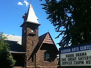
Barron Library
United States historic place
Distance: Approx. 1087 meters
Latitude and longitude: 40.56111111,-74.27361111
The Barron Library is a historic building located at 582 Rahway Avenue in Woodbridge Township, Middlesex County, New Jersey. Formerly a public library, it is now the Barron Arts Center. The building was documented by the Historic American Buildings Survey in 1976.
Weather in this IP's area
broken clouds
19 Celsius
19 Celsius
16 Celsius
21 Celsius
1020 hPa
71 %
1020 hPa
1019 hPa
10000 meters
3.09 m/s
10 degree
75 %
05:49:51
20:17:12