Country:
 USA
USARegion:
City:
Latitude and Longitude:
Time Zone:
Postal Code:
IP information under different IP Channel
ip-api
Country
Region
City
ASN
Time Zone
ISP
Blacklist
Proxy
Latitude
Longitude
Postal
Route
IPinfo
Country
Region
City
ASN
Time Zone
ISP
Blacklist
Proxy
Latitude
Longitude
Postal
Route
MaxMind
Country
Region
City
ASN
Time Zone
ISP
Blacklist
Proxy
Latitude
Longitude
Postal
Route
Luminati
Country
USRegion
ca
City
sanmateo
ASN
Time Zone
America/Los_Angeles
ISP
COMCAST-7922
Latitude
Longitude
Postal
db-ip
Country
Region
City
ASN
Time Zone
ISP
Blacklist
Proxy
Latitude
Longitude
Postal
Route
ipdata
Country
Region
City
ASN
Time Zone
ISP
Blacklist
Proxy
Latitude
Longitude
Postal
Route
Popular places and events near this IP address

Cotati, California
City in California, United States
Distance: Approx. 1498 meters
Latitude and longitude: 38.32777778,-122.70916667
Cotati (; Miwok: Kota’ti) is an incorporated city in Sonoma County, California, United States, located approximately 45 mi (70 km) north of San Francisco in the 101 corridor between Rohnert Park and Petaluma. Cotati's population as of the 2020 Census was 7,584, making it the smallest incorporated community in Sonoma County. Like all of Sonoma County, Cotati is included in both the San Francisco Bay Area and North Coast.

Rohnert Park, California
City in California, United States
Distance: Approx. 984 meters
Latitude and longitude: 38.34722222,-122.69527778
Rohnert Park is a city in Sonoma County, California, United States, located approximately 50 miles (80 km) north of San Francisco. The population at the 2020 United States Census was 44,390. It is an early planned city and is the sister city of Hashimoto in Japan.

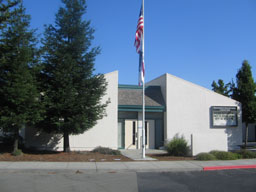
Technology High School (Rohnert Park, California)
Magnet school in Rohnert Park, California, United States
Distance: Approx. 655 meters
Latitude and longitude: 38.33388889,-122.7
Technology High School is a magnet school with a focus in science, math and technology, located in Sonoma County, California. It was founded in 1995 under the Cotati-Rohnert Park Unified School District on the Sonoma State University campus. It was sponsored by Hewlett-Packard and the Autodesk foundation.
El Camino High School (Rohnert Park)
School in Rohnert Park, California
Distance: Approx. 934 meters
Latitude and longitude: 38.34055556,-122.69055556
El Camino High School is an alternative education high school located in Rohnert Park, California in the United States.

Copeland Creek (California)
River in California, United States
Distance: Approx. 2005 meters
Latitude and longitude: 38.34361111,-122.72361111
Copeland Creek is a 9.0-mile-long (14.5 km) perennial stream that rises on Sonoma Mountain in Sonoma County, California.

Rancho Cotate High School
Public high school in the United States
Distance: Approx. 1467 meters
Latitude and longitude: 38.34047,-122.684431
Rancho Cotate High School is a four-year comprehensive high school in Rohnert Park, California. It is located at 5450 Snyder Lane, adjacent to the campus of Sonoma State University. Students have opportunities to participate in a wide variety of sports and extra curricular activities.
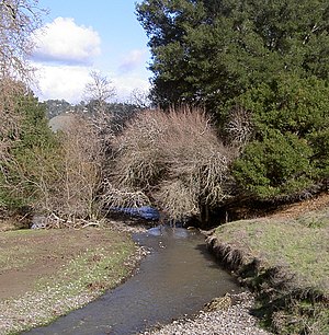
Crane Creek (California)
River in California, United States
Distance: Approx. 1967 meters
Latitude and longitude: 38.35527778,-122.69055556
Crane Creek is a stream in Sonoma County, California, United States which rises in the northern Sonoma Mountains. This watercourse flows through Crane Canyon and the Crane Creek Regional Park situated on the northwestern flank of Sonoma Mountain. Crane Creek forms a confluence with Hinebaugh Creek in the city of Rohnert Park; thereafter, the channelized Hinebaugh Creek flows westerly to discharge to the Laguna de Santa Rosa.

Cotati Jazz Festival
Annual music festival in California, United States
Distance: Approx. 1540 meters
Latitude and longitude: 38.32669,-122.70721
The Cotati Jazz Festival is an annual music festival held in Cotati, California, United States, since 1981. It typically takes place mid-June. Since 2006, admission has been free.
Naval Outlying Landing Field Cotati
Airport in Cotati, California
Distance: Approx. 2002 meters
Latitude and longitude: 38.35,-122.72
Naval Outlying Landing Field Cotati was a naval airfield located near Cotati, in Sonoma County, California, USA. It maintained active naval flight operations during the period 1941–1945.

Cotati station
Rail station in Cotati, California, US
Distance: Approx. 1302 meters
Latitude and longitude: 38.3311,-122.6911
Cotati station is a Sonoma–Marin Area Rail Transit station in Cotati, California. It opened to preview service on June 29, 2017; full commuter service commenced on August 25, 2017. It is located on Cotati Avenue.
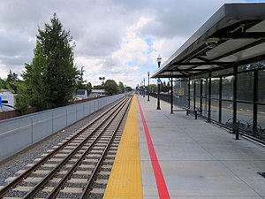
Rohnert Park station
Distance: Approx. 835 meters
Latitude and longitude: 38.3472,-122.7011
Rohnert Park station is a Sonoma–Marin Area Rail Transit station in the city of the same name. It opened to preview service on June 29, 2017; full commuter service commenced on August 25, 2017. It is located on the Rohnert Park Expressway.

Cotati Speedway
Auto racing track (1921–1922)
Distance: Approx. 1626 meters
Latitude and longitude: 38.327,-122.692
The Cotati Speedway was a 1.25-mile (2.01 km) wooden board track for automobile racing in Cotati, California. The track was built and opened in 1921, and featured heavily banked turns, which were around 41.5° at their steepest. It hosted six AAA Championship Car races across 1921 and 1922.
Weather in this IP's area
broken clouds
13 Celsius
12 Celsius
12 Celsius
14 Celsius
1012 hPa
82 %
1012 hPa
1008 hPa
10000 meters
1.34 m/s
2.24 m/s
220 degree
58 %
06:09:11
20:25:12