Country:
 USA
USARegion:
City:
Latitude and Longitude:
Time Zone:
Postal Code:
IP information under different IP Channel
ip-api
Country
Region
City
ASN
Time Zone
ISP
Blacklist
Proxy
Latitude
Longitude
Postal
Route
IPinfo
Country
Region
City
ASN
Time Zone
ISP
Blacklist
Proxy
Latitude
Longitude
Postal
Route
MaxMind
Country
Region
City
ASN
Time Zone
ISP
Blacklist
Proxy
Latitude
Longitude
Postal
Route
Luminati
Country
USRegion
ca
City
losangeles
ASN
Time Zone
America/Los_Angeles
ISP
TWC-20001-PACWEST
Latitude
Longitude
Postal
db-ip
Country
Region
City
ASN
Time Zone
ISP
Blacklist
Proxy
Latitude
Longitude
Postal
Route
ipdata
Country
Region
City
ASN
Time Zone
ISP
Blacklist
Proxy
Latitude
Longitude
Postal
Route
Popular places and events near this IP address

Los Angeles City Hall
1928 building housing the government of the city of Los Angeles, California
Distance: Approx. 139 meters
Latitude and longitude: 34.0536,-118.243
Los Angeles City Hall, completed in 1928, is the center of the government of the city of Los Angeles, California, and houses the mayor's office and the meeting chambers and offices of the Los Angeles City Council. It is located in the Civic Center district of downtown Los Angeles in the city block bounded by Main, Temple, First, and Spring streets, which was the heart of the city's central business district during the 1880s and 1890s. The Observation Deck or Tom Bradley Tower located on the 27th floor is open to the public.

Los Angeles Times bombing
1910 bombing by trade union activists
Distance: Approx. 105 meters
Latitude and longitude: 34.05284,-118.245
The Los Angeles Times bombing was the purposeful dynamiting of the Los Angeles Times Building in Los Angeles, California, United States, on October 1, 1910, by a union member belonging to the International Association of Bridge and Structural Iron Workers (IW). The explosion started a fire which killed 21 occupants and injured 100 more. It was termed the "crime of the century" by the Los Angeles Times newspaper, which occupied the building.

Caltrans District 7 Headquarters
Building in Los Angeles, United States
Distance: Approx. 134 meters
Latitude and longitude: 34.0514,-118.2439
The Caltrans District 7 Headquarters building at 100 South Main Street in Downtown Los Angeles, California, United States serves the California Department of Transportation (Caltrans) and the Los Angeles Department of Transportation. Built on a $165 million budget, it opened on September 24, 2004. Its futuristic and environmentally friendly design won its designer, Thom Mayne, the 2005 Pritzker Prize.

Times Mirror Square
Complex of buildings in Los Angeles
Distance: Approx. 79 meters
Latitude and longitude: 34.053009,-118.244596
Times Mirror Square is a complex of buildings on the block bounded by Spring, Broadway, First and Second streets in the Civic Center district of Downtown Los Angeles. It was headquarters of the Los Angeles Times until 2018. It is currently vacant, with plans being proposed regarding how to best utilize the existing buildings and the total ground area of the site.

Los Angeles Police Department Memorial for Fallen Officers
Monument in Los Angeles, California
Distance: Approx. 119 meters
Latitude and longitude: 34.051588,-118.244306
The Los Angeles Police Department Memorial to Fallen Officers is a monument on an elevated plaza at the LAPD headquarters on 100 West 1st Street in downtown Los Angeles. The memorial was funded by the Los Angeles Police Foundation, who raised the $750,000 through private donations. The original tribute to fallen officers that was located at the previous headquarters at Parker Center was destroyed in the process of transport when moved to make room for a new jail.
Los Angeles Theatre Center
Distance: Approx. 50 meters
Latitude and longitude: 34.05222222,-118.24361111
The Los Angeles Theatre Center is an institution in Los Angeles, which is operated by the Latino Theater Company. In January 2006, the Latino Theater Company won a lease to operate The Los Angeles Theatre Center for 20 years and got a $4 million grant from the California Cultural and Historical Endowment to renovate the building. In October 2007, the building was re-opened as the new Los Angeles Theatre Center.

Lindbergh Beacon (Los Angeles)
Aircraft beacon on Los Angeles City Hall
Distance: Approx. 139 meters
Latitude and longitude: 34.0536,-118.243
The Lindbergh Beacon, an aircraft beacon atop the Los Angeles City Hall, operated nightly from April 26, 1928, until just after the attack on Pearl Harbor. It was restored to its original condition in 2001, and Los Angeles magazine described it as "a tiara of light atop our beautifully restored Los Angeles City Hall." City officials now occasionally put the beacon into operation for special occasions such as the year-end holidays.

Victorian Downtown Los Angeles
Historical neighborhood in California, US
Distance: Approx. 45 meters
Latitude and longitude: 34.053,-118.244
The late-Victorian-era Downtown of Los Angeles in 1880 was centered at the southern end of the Los Angeles Plaza area, and over the next two decades, it extended south and west along Main Street, Spring Street, and Broadway towards Third Street. Most of the 19th-century buildings no longer exist, surviving only in the Plaza area or south of Second Street. The rest were demolished to make way for the Civic Center district with City Hall, numerous courthouses, and other municipal, county, state and federal buildings, and Times Mirror Square.

California State Building (Los Angeles)
Demolished office building in Los Angeles, California
Distance: Approx. 107 meters
Latitude and longitude: 34.053416,-118.244512
The California State Building, originally referred to simply as the State Office Building, was a 13-story PWA Moderne building housing state offices, at the northwest corner of First and Spring streets in the Civic Center district of Downtown Los Angeles. It was completed in 1931 and opened in 1932. Analysis after the 1971 Sylmar earthquake showed it to be structurally unsound and it was demolished in 1975–1976.
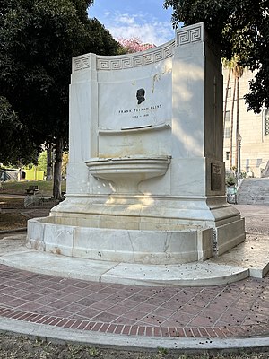
Frank Putnam Flint Fountain
Monument in Los Angeles, California, U.S.
Distance: Approx. 43 meters
Latitude and longitude: 34.05286111,-118.24355556
The Frank Putnam Flint Fountain, also known as the Flint Memorial, is a monument commemorating Frank Putnam Flint, who was a United States Senator from California, in Los Angeles. It is located on the south lawn of Los Angeles City Hall facing 1st Street.

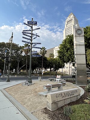
Los Angeles Sister Cities Monument
Fingerpost in Los Angeles, California, U.S.
Distance: Approx. 79 meters
Latitude and longitude: 34.05227778,-118.24313889
The Los Angeles Sister Cities Monument, also known as the Sister Cities of Los Angeles Monument, is a fingerpost and monument in Los Angeles' Civic Center, in the U.S. state of California. The monument was designed by Brigid LaBonge in 2002. Installed at the corner of 1st and Main, in front of South City Hall and across from Los Angeles City Hall, the fingerpost displays the names and distances of Los Angeles' sister cities.
Nagoya Clock Tower
Clock tower in Los Angeles, California, U.S.
Distance: Approx. 84 meters
Latitude and longitude: 34.05230556,-118.24305556
The Nagoya Clock Tower is a clock tower in Los Angeles' Civic Center, in the U.S. state of California. The clock was gifted by the people of Nagoya to those of Los Angeles in 1984, on the 25th anniversary of the Sister City program.
Weather in this IP's area
few clouds
18 Celsius
18 Celsius
17 Celsius
21 Celsius
1011 hPa
79 %
1011 hPa
1000 hPa
10000 meters
3.09 m/s
90 degree
20 %
06:01:03
19:57:40