Country:
 Austria
Region:
City:
Latitude and Longitude:
Time Zone:
Postal Code:
IP information under different IP Channel
ip-api
Country
Region
City
ASN
Time Zone
ISP
Blacklist
Proxy
Latitude
Longitude
Postal
Route
IPinfo
Country
Region
City
ASN
Time Zone
ISP
Blacklist
Proxy
Latitude
Longitude
Postal
Route
MaxMind
Country
Region
City
ASN
Time Zone
ISP
Blacklist
Proxy
Latitude
Longitude
Postal
Route
Luminati
Country
ATRegion
7
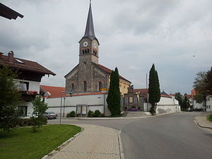
City
kufstein
ASN
Time Zone
Europe/Vienna
ISP
Stadtwerke Kufstein GmbH
Latitude
Longitude
Postal
db-ip
Country
Region
City
ASN
Time Zone
ISP
Blacklist
Proxy
Latitude
Longitude
Postal
Route
ipdata
Country
Region
City
ASN
Time Zone
ISP
Blacklist
Proxy
Latitude
Longitude
Postal
Route
Popular places and events near this IP address

Reit im Winkl
Municipality in Bavaria, Germany
Distance: Approx. 4829 meters
Latitude and longitude: 47.68333333,12.46666667
Reit im Winkl is a small village (locally known as a snow-magnet) located on the German/Austrian border in the southeastern part of Bavaria, Germany. Part of the Traunstein district, it was previously an immigration and customs control point (prior to the formation of the Schengen Zone). It is situated south of Chiemsee and southwest of Ruhpolding – home of the Biathlon World Cup – in the Bavarian Alps and facing towards Tyrol.
Grabenstätt
Municipality in Bavaria, Germany
Distance: Approx. 5222 meters
Latitude and longitude: 47.71666667,12.4
Grabenstätt is a municipality in the district of Traunstein in Bavaria, Germany.
Schleching
Municipality in Bavaria, Germany
Distance: Approx. 5222 meters
Latitude and longitude: 47.71666667,12.4
Schleching is a municipality and a village in Traunstein district in Bavaria, Germany.

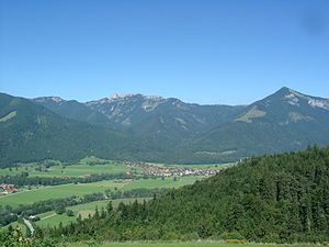
Kössen
Place in Tyrol, Austria
Distance: Approx. 542 meters
Latitude and longitude: 47.66666667,12.4
Kössen is a municipality in the Kitzbühel district in the Austrian state of Tyrol located 24 km north of Kitzbühel as well as 15.50 km north of Sankt Johann in Tirol at the Kitzbühler Ache near the border to Germany.

Schwendt
Place in Tyrol, Austria
Distance: Approx. 4091 meters
Latitude and longitude: 47.63333333,12.4
Schwendt is a municipality in the Kitzbühel district in the Austrian state of Tyrol located 17 km north of Kitzbühel and 6 km below Kössen. The name of the village comes from the old word "schwenden" (meaning to grub-up). Agriculture and tourism are its main sources of income.

Geigelstein
Distance: Approx. 6790 meters
Latitude and longitude: 47.70785278,12.33447222
Geigelstein is a mountain in Bavaria, Germany with an elevation of 1,808 meters. It is a mountain within the Chiemgau Alps. The highest point contains a small plateau with a cross.
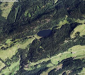
Taubensee (Kössen/Unterwössen)
Distance: Approx. 3335 meters
Latitude and longitude: 47.69611111,12.42694444
Taubensee (Kössen/Unterwössen) is a lake of Tyrol, Austria.

Unterberghorn
Distance: Approx. 5956 meters
Latitude and longitude: 47.62056,12.43611
The Unterberghorn (1,773 m (AA)) in the Austrian district of Kitzbühel in Tyrol is the highest peak between the mountain ranges of the Wilder Kaiser and Loferer Steinberge. The horn or pyramidal peak has two summits - its subpeak is the Hefferthorn (1,735 m) - and is the local mountain (Hausberg) for the villages of Kössen (near the Bavarian border) and St. Johann in Tirol, between which it rises, west of the valley of the River Großache.

Schwarzlofer
River in Germany
Distance: Approx. 1440 meters
Latitude and longitude: 47.6619,12.4205
Schwarzlofer is a river of Tyrol, Austria and Bavaria, Germany. Its source is on the Schwarzloferalm, north of Waidring (Tyrol). It passes through Reit im Winkl (Bavaria) and flows into the Großache near Kössen (Tyrol).

Walchsee (lake)
Lake in Tyrol, Austria
Distance: Approx. 6658 meters
Latitude and longitude: 47.646,12.324
Walchsee is a lake in Kufstein District in both Walchsee and Kössen municipalities, Tyrol, Austria. Its surface area of 95.3 hectares (235 acres) makes it the fourth largest natural waterbody in the state. Its maximum depth is 21.2 metres (70 ft), and its maximum volume is 11,782,560 cubic metres (416,097,000 cu ft).

Brunnbach (Hagertal)
River in Tyrol, Austria
Distance: Approx. 5498 meters
Latitude and longitude: 47.63603,12.45877
The Brunnbach is a river of Tyrol, Austria, in the protected landscape Hefferthorn-Fellhorn-Sonnenberg.

Entenloch Gorge
Water gap in Germany
Distance: Approx. 2312 meters
Latitude and longitude: 47.68916667,12.39388889
The Entenloch Gorge (German: Entenlochklamm) is a 2.5-km long water gap of the Leukental in the Bavarian-Tyrolian border area between Kössen and Ettenhausen bei Schleching. Coming from the south, the Großache cuts through a transverse mountain range of steep rocks, reaches the border at the pilgrimage site Maria Klobenstein, and from then on is called the Tiroler Achen.
Weather in this IP's area
broken clouds
30 Celsius
30 Celsius
29 Celsius
31 Celsius
1015 hPa
43 %
1015 hPa
949 hPa
10000 meters
1.68 m/s
2.21 m/s
340 degree
59 %
05:41:36
20:51:55