Country:
 Sweden
Region:
City:
Latitude and Longitude:
Time Zone:
Postal Code:
IP information under different IP Channel
ip-api
Country
Region
City
ASN
Time Zone
ISP
Blacklist
Proxy
Latitude
Longitude
Postal
Route
IPinfo
Country
Region
City
ASN
Time Zone
ISP
Blacklist
Proxy
Latitude
Longitude
Postal
Route
MaxMind
Country
Region
City
ASN
Time Zone
ISP
Blacklist
Proxy
Latitude
Longitude
Postal
Route
Luminati
Country
SERegion
z
City
froso
ASN
Time Zone
Europe/Stockholm
ISP
Telia Company AB
Latitude
Longitude
Postal
db-ip
Country
Region
City
ASN
Time Zone
ISP
Blacklist
Proxy
Latitude
Longitude
Postal
Route
ipdata
Country
Region
City
ASN
Time Zone
ISP
Blacklist
Proxy
Latitude
Longitude
Postal
Route
Popular places and events near this IP address

Alingsås Municipality
Municipality in Västra Götaland County, Sweden
Distance: Approx. 338 meters
Latitude and longitude: 57.93333333,12.53333333
Alingsås Municipality (Alingsås kommun) is a municipality in Västra Götaland County in western Sweden. Its seat is located in the city of Alingsås. The present municipality was formed in 1974 then the former City of Alingsås (itself a municipality of unitary type since the subdivision reform of 1971) was amalgamated with Bjärke and Hemsjö.

Alingsås
Place in Västergötland, Sweden
Distance: Approx. 46 meters
Latitude and longitude: 57.93,12.53305556
Alingsås (Swedish pronunciation: [alɪŋˈsoːs] ) is a locality and the seat of Alingsås Municipality in Västra Götaland County, Sweden. It had 24,482 inhabitants in 2010.
Norsesund
Place in Västergötland, Sweden
Distance: Approx. 9239 meters
Latitude and longitude: 57.86666667,12.43333333
Norsesund is a bimunicipal locality situated in Alingsås Municipality and Lerum Municipality in Västra Götaland County, Sweden. It had 274 inhabitants in 2010.
Hjälmared, Alingsås
Place in Västergötland, Sweden
Distance: Approx. 5228 meters
Latitude and longitude: 57.88333333,12.53333333
Hjälmared is a locality situated in Alingsås Municipality, Västra Götaland County, Sweden. It had 260 inhabitants in 2010.
Ingared
Place in Västergötland, Sweden
Distance: Approx. 9777 meters
Latitude and longitude: 57.85,12.46666667
Ingared is a locality situated in Alingsås Municipality, Västra Götaland County, Sweden. It had 1,299 inhabitants in 2010.

Västra Bodarna
Place in Västergötland, Sweden
Distance: Approx. 6014 meters
Latitude and longitude: 57.88333333,12.48333333
Västra Bodarna (Västra Bodarne) is a locality situated in Alingsås Municipality, Västra Götaland County, Sweden. It had 1,059 inhabitants in 2010.
Sjövik
Place in Västergötland, Sweden
Distance: Approx. 9985 meters
Latitude and longitude: 57.91666667,12.36666667
Sjövik is a locality situated in Lerum Municipality, Västra Götaland County, Sweden. It had 905 inhabitants in 2010.
Alströmergymnasiet
High school in Alingsås, Sweden
Distance: Approx. 903 meters
Latitude and longitude: 57.938,12.5288
Alströmergymnasiet is a high school in Alingsås, Sweden, opened in 1969.
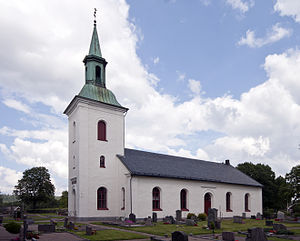
Hemsjö Church
Distance: Approx. 9775 meters
Latitude and longitude: 57.8475,12.47861111
Hemsjö Church (Swedish: Hemsjö kyrka) is a church in Hemsjö, Alingsås, Västergötland, Sweden. It belongs to the parish of Hemsjö parish in the Diocese of Skara. Hemsjö church is believed to be the fourth church in the village and was inaugurated on October 5, 1862, about 900 metres west of the site where the earlier churches stood.

Noltorp Church
Distance: Approx. 1195 meters
Latitude and longitude: 57.9375,12.51861111
Noltorp Church (Swedish: Noltorpskyrkan) is a church in Alingsås, Västergötland, Sweden. It is partner church, run in collaboration between the Alingsås Assembly and the ETUC Mission Association in Noltorp. The church was built in 1991 and replaced an earlier place of worship which was housed in a wooden villa.

Mjörn (lake)
Lake in Västergötland.
Distance: Approx. 8065 meters
Latitude and longitude: 57.90033889,12.40941111
Mjörn is a lake in Västergötland, shared between the municipalities of Alingsås and Lerum and is part of the main catchment area of the Göta River. The lake is 48 meters deep, covers an area of 54.5 square kilometers and has an elevation of 57.1 meters above sea level.
Weather in this IP's area
clear sky
17 Celsius
17 Celsius
17 Celsius
19 Celsius
1011 hPa
53 %
1011 hPa
1003 hPa
10000 meters
4.57 m/s
6.59 m/s
241 degree
1 %
04:53:50
21:38:40