Country:
 Belgium
Region:
City:
Latitude and Longitude:
Time Zone:
Postal Code:
IP information under different IP Channel
ip-api
Country
Region
City
ASN
Time Zone
ISP
Blacklist
Proxy
Latitude
Longitude
Postal
Route
IPinfo
Country
Region
City
ASN
Time Zone
ISP
Blacklist
Proxy
Latitude
Longitude
Postal
Route
MaxMind
Country
Region
City
ASN
Time Zone
ISP
Blacklist
Proxy
Latitude
Longitude
Postal
Route
Luminati
Country
BERegion
wal
City
courcelles
ASN
Time Zone
Europe/Brussels
ISP
Proximus NV
Latitude
Longitude
Postal
db-ip
Country
Region
City
ASN
Time Zone
ISP
Blacklist
Proxy
Latitude
Longitude
Postal
Route
ipdata
Country
Region
City
ASN
Time Zone
ISP
Blacklist
Proxy
Latitude
Longitude
Postal
Route
Popular places and events near this IP address
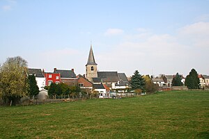
Erquelinnes
Municipality in French Community, Belgium
Distance: Approx. 858 meters
Latitude and longitude: 50.3,4.11666667
Erquelinnes (French pronunciation: [ɛʁkəlin] ; Walloon: Erkelene) is a municipality of Wallonia located in the province of Hainaut, Belgium. Located on the border with France, where the commune of Maubeuge lies, Erquelinnes had a total resident population of 9,549, in 2006. The total area is 44.23 km2 (17.08 sq mi) which gives a population density of 216 inhabitants per km2.

Merbes-le-Château
Municipality in French Community, Belgium
Distance: Approx. 4273 meters
Latitude and longitude: 50.323724,4.165329
Merbes-le-Château (French pronunciation: [mɛʁb lə ʃɑto]; Walloon: Miebe) is a municipality of Wallonia located in the province of Hainaut, Belgium. On January 1, 2006, Merbes-le-Château had a total population of 4,093. The total area is 30.24 km2 which gives a population density of 135 inhabitants per km2.

Grand-Reng
Distance: Approx. 4327 meters
Latitude and longitude: 50.33333333,4.06666667
Grand-Reng (French pronunciation: [ɡʁɑ̃ ʁɑ̃]; Walloon: Grand-Rin) is a village of Wallonia and a district of the municipality of Erquelinnes, located in the province of Hainaut, Belgium. It is located on the border with France, on the main road from Mons to Beaumont. Its French neighbour is called Vieux-Reng.

Vieux-Reng
Commune in Hauts-de-France, France
Distance: Approx. 5195 meters
Latitude and longitude: 50.33,4.0478
Vieux-Reng (French pronunciation: [vjø ʁɑ̃]) is a commune in the Nord department in northern France. Its neighbouring village across the border with Belgium is called Grand-Reng.

Jeumont
Commune in Hauts-de-France, France
Distance: Approx. 1454 meters
Latitude and longitude: 50.2953,4.1019
Jeumont (French pronunciation: [ʒømɔ̃]) is a commune in the Nord department in northern France. It lies on the Belgian border and on the river Sambre, adjacent to the Belgian town Erquelinnes. It is part of the agglomeration (unité urbaine) of Maubeuge.
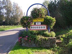
Boussois
Commune in Hauts-de-France, France
Distance: Approx. 5252 meters
Latitude and longitude: 50.2911,4.0417
Boussois (French pronunciation: [buswa]) is a commune in the Nord department in northern France.

Marpent
Commune in Hauts-de-France, France
Distance: Approx. 2776 meters
Latitude and longitude: 50.292,4.08
Marpent (French pronunciation: [maʁpɑ̃]) is a commune in the Nord department in northern France. It hosts an important factory of railway rolling stock, the former Baume et Marpent.
Recquignies
Commune in Hauts-de-France, France
Distance: Approx. 5771 meters
Latitude and longitude: 50.281,4.041
Recquignies (French pronunciation: [ʁɛkiɲi]) is a commune in the Nord department in northern France.

Solre-sur-Sambre Castle
Distance: Approx. 3116 meters
Latitude and longitude: 50.309,4.155
Solre-sur-Sambre Castle (French: Château de Solre-sur-Sambre) is a water castle in Solre-sur-Sambre in the municipality of Erquelinnes, province of Hainaut, Wallonia, Belgium. It is one of the oldest fortified castles in Hainaut, and the property of the Princes de Merode.
Battle of Erquelinnes
Battle of the War of the First Coalition
Distance: Approx. 858 meters
Latitude and longitude: 50.3,4.11666667
The Battle of Erquelinnes or Battle of Péchant (24 May 1794) was part of the Flanders Campaign during the War of the First Coalition, and saw a Republican French army jointly led by Jacques Desjardin and Louis Charbonnier try to defend a bridgehead on the north bank of the Sambre River against a combined Habsburg Austrian and Dutch army led by Franz Wenzel, Graf von Kaunitz-Rietberg. The French crossed the Sambre on the 20th and held their positions for a few days. On the 24th Kaunitz launched an early-morning surprise attack that routed the French.

Battle of Grand-Reng
Battle of the War of the First Coalition
Distance: Approx. 4327 meters
Latitude and longitude: 50.33333333,4.06666667
The Battle of Grand-Reng or Battle of Rouvroi (13 May 1794) saw a Republican French army jointly commanded by Louis Charbonnier and Jacques Desjardin attempt to advance across the Sambre River against a combined Habsburg Austrian and Dutch army under Franz Wenzel, Graf von Kaunitz-Rietberg. After winning crossings over the Sambre at Thuin and Lobbes on the 10th and Merbes-le-Château on the 12th, the French were defeated on 13 May at Grand-Reng and forced to retreat. The War of the First Coalition engagement marked the first of five attempts by the French armies to establish themselves on the north bank of the Sambre.

Decauville railway of the Watissart quarries
Distance: Approx. 2662 meters
Latitude and longitude: 50.28494,4.0965
The Decauville railway of the Watissart quarries was a narrow-gauge railway of the quartzite and marble quarries in Jeumont in the Département Nord in the Hauts-de-France region. The former quarries have been flooded to create a lake that is now used as a nature reserve and recreational area for fishing, swimming and diving.
Weather in this IP's area
overcast clouds
18 Celsius
19 Celsius
17 Celsius
20 Celsius
1014 hPa
99 %
1014 hPa
998 hPa
10000 meters
0.69 m/s
1 m/s
108 degree
100 %
06:05:07
21:34:45