Country:
 Great Britain
Region:
City:
Latitude and Longitude:
Time Zone:
Postal Code:
IP information under different IP Channel
ip-api
Country
Region
City
ASN
Time Zone
ISP
Blacklist
Proxy
Latitude
Longitude
Postal
Route
IPinfo
Country
Region
City
ASN
Time Zone
ISP
Blacklist
Proxy
Latitude
Longitude
Postal
Route
MaxMind
Country
Region
City
ASN
Time Zone
ISP
Blacklist
Proxy
Latitude
Longitude
Postal
Route
Luminati
Country
GBRegion
eng
City
birmingham
ASN
Time Zone
Europe/London
ISP
Vodafone Limited
Latitude
Longitude
Postal
db-ip
Country
Region
City
ASN
Time Zone
ISP
Blacklist
Proxy
Latitude
Longitude
Postal
Route
ipdata
Country
Region
City
ASN
Time Zone
ISP
Blacklist
Proxy
Latitude
Longitude
Postal
Route
Popular places and events near this IP address

Lothingland Rural District
Former rural district in East Suffolk, England
Distance: Approx. 2128 meters
Latitude and longitude: 52.44,1.71
Lothingland was a rural district in East Suffolk, England, named after the ancient half-hundred of Lothingland which was merged with Mutford half-hundred in 1763 to form Mutford and Lothingland. The rural district was formed in 1934 by the merger of most of Mutford and Lothingland Rural District along with part of Blything Rural District, both of which were being abolished. It covered a coastal area between Great Yarmouth and Lowestoft.
Kirkley & Pakefield F.C.
Association football club in England
Distance: Approx. 379 meters
Latitude and longitude: 52.45623611,1.72651667
Kirkley & Pakefield Football Club is a football club based in Lowestoft, Suffolk, England. They are currently members of the Eastern Counties League Premier Division and play at Walmer Road.
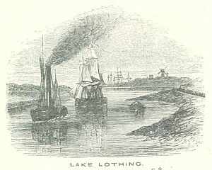
Lake Lothing
Distance: Approx. 2213 meters
Latitude and longitude: 52.474,1.734
Lake Lothing is a saltwater lake located in Lowestoft in the English county of Suffolk. The lake, which is believed to be the remnant of medieval peat cutting, flows into the North Sea and forms part of the Port of Lowestoft. The area was the major industrial centre of Lowestoft with ship building and other engineering industries, much of which has now closed.

Kirkley
Human settlement in England
Distance: Approx. 1293 meters
Latitude and longitude: 52.465,1.738
Kirkley is an area of the town of Lowestoft in the East Suffolk district of the English county of Suffolk. It is located south of the centre of Lowestoft and the town's harbour and Lake Lothing. Kirkley was originally an independent village but is now part of the urban conurbation of Lowestoft.

Pakefield
Human settlement in England
Distance: Approx. 410 meters
Latitude and longitude: 52.451,1.728
Pakefield is a suburb of the town of Lowestoft, in the East Suffolk district, in the north of the English county of Suffolk. It is located around 2 miles (3.2 km) south of the centre of the town. It 2011 the ward had a population of 6,563.
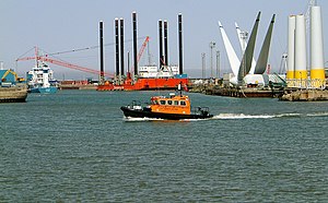
Port of Lowestoft
Distance: Approx. 2180 meters
Latitude and longitude: 52.473,1.74
The Port of Lowestoft is a harbour and commercial port in Lowestoft in the English county of Suffolk owned by Associated British Ports. It is the most easterly harbour in the United Kingdom and has direct sea access to the North Sea. The harbour is made up of two sections divided by a bascule bridge.
Pakefield High School
Academy in Lowestoft, Suffolk, England
Distance: Approx. 633 meters
Latitude and longitude: 52.4497,1.7253
Pakefield High School is a co-educational secondary school located in Pakefield, a suburb of Lowestoft in the English county of Suffolk. The school opened in September 2011, initially with Years 7 and 8 only, using buildings which were previously Pakefield Middle School. The school became the first new state high school to be built in Suffolk for over 20 years as part of the reorganisation of schools in Lowestoft, a process which saw the closure of eight middle schools and a change from transfer to high school at age 13 to transfer at age 11.
Claremont Pier
Distance: Approx. 1652 meters
Latitude and longitude: 52.4657,1.7464
The Claremont Pier is a traditional seaside pier in Lowestoft in the English county of Suffolk. Opened in 1903 and named after nearby Claremont Road, the pier was sectioned during the war through fear it could be used for an enemy invasion. It was subsequently restored using a Bailey Bridge and used as a training facility for the army.
East Point Academy
Academy in Lowestoft, Suffolk, England
Distance: Approx. 1573 meters
Latitude and longitude: 52.46824,1.7284
East Point Academy is an academy sponsored by the Inspiration Trust, located in the Kirkley district of Lowestoft, in the English county of Suffolk. It educates children from ages 11 to 16. In its latest Ofsted inspection in October 2016, the academy overall was rated as "Good".
Pakefield Lighthouse
Lighthouse
Distance: Approx. 1918 meters
Latitude and longitude: 52.437,1.7293
Pakefield Lighthouse is a decommissioned 19th century lighthouse which was built near Pakefield a suburb of Lowestoft in Suffolk. The lighthouse tower has been used for a variety of maritime, civilian and military roles, and is currently used as a Coastwatch lookout post. Completed in 1832 to a design by the architect Richard Suter, it was commissioned by Trinity House to enable a safe passage to be made through Pakefield Gatway (a channel between two shifting sandbanks providing a way into Lowestoft harbour).

Kirkley Cemetery
Cemetery in Suffolk, England
Distance: Approx. 703 meters
Latitude and longitude: 52.4603,1.7337
Kirkley Cemetery is a burial ground in the Kirkley area of Lowestoft in Suffolk. Located on London Road South, the cemetery is maintained by Waveney District Council and is open for traditional and Green Burials. The cemetery contains 59 war burials from both World Wars which are registered with and maintained by the Commonwealth War Graves Commission.

Gull Wing Bridge
Future road bridge in Lowestoft
Distance: Approx. 2208 meters
Latitude and longitude: 52.474,1.733
Gull Wing Bridge is a road bridge being built to span Lake Lothing in the town of Lowestoft, Suffolk, England, which is claimed to be (once completed) the largest rolling bascule bridge in the world lifted using hydraulic cylinders. The bridge is planned to be completed and open to traffic in the summer of 2024. The bridge will be higher than the existing bascule bridge at the harbour mouth, and so will not need to be lifted up as often for shipping to pass underneath.
Weather in this IP's area
scattered clouds
15 Celsius
15 Celsius
14 Celsius
16 Celsius
1012 hPa
78 %
1012 hPa
1011 hPa
10000 meters
2.28 m/s
2.57 m/s
291 degree
31 %
05:05:45
20:53:10