Country:
 France
Region:
City:
Latitude and Longitude:
Time Zone:
Postal Code:
IP information under different IP Channel
ip-api
Country
Region
City
ASN
Time Zone
ISP
Blacklist
Proxy
Latitude
Longitude
Postal
Route
IPinfo
Country
Region
City
ASN
Time Zone
ISP
Blacklist
Proxy
Latitude
Longitude
Postal
Route
MaxMind
Country
Region
City
ASN
Time Zone
ISP
Blacklist
Proxy
Latitude
Longitude
Postal
Route
Luminati
Country
FRRegion
ara
City
lyon
ASN
Time Zone
Europe/Paris
ISP
Orange
Latitude
Longitude
Postal
db-ip
Country
Region
City
ASN
Time Zone
ISP
Blacklist
Proxy
Latitude
Longitude
Postal
Route
ipdata
Country
Region
City
ASN
Time Zone
ISP
Blacklist
Proxy
Latitude
Longitude
Postal
Route
Popular places and events near this IP address

Varambon
Commune in Auvergne-Rhône-Alpes, France
Distance: Approx. 4689 meters
Latitude and longitude: 46.0333,5.3167
Varambon (French pronunciation: [vaʁɑ̃bɔ̃]) is a commune in the central part of the Ain department in the Auvergne-Rhône-Alpes region in Eastern France. It is located just southwest of Pont-d'Ain, northwest of Ambérieu-en-Bugey.

L'Abergement-de-Varey
Commune in Auvergne-Rhône-Alpes, France
Distance: Approx. 4977 meters
Latitude and longitude: 46.0078,5.4253
L'Abergement-de-Varey (French pronunciation: [labɛʁʒəmɑ̃ də vaʁɛ] ) is a commune in the department of Ain in eastern France.

Ambérieu-en-Bugey
Commune in Auvergne-Rhône-Alpes, France
Distance: Approx. 4651 meters
Latitude and longitude: 45.9631,5.3541
Ambérieu-en-Bugey (French pronunciation: [ɑ̃beʁjø ɑ̃ byʒɛ, byʒe] ; Arpitan: Ambèriô) is a commune in the Ain department, Auvergne-Rhône-Alpes region, France. With 14,288 inhabitants (2020), it is one of the largest towns of the historical region of Bugey. It is the largest town in the arrondissement of Belley and the seat of the canton of Ambérieu-en-Bugey which consists of 18 communes.
Ambronay
Commune in Auvergne-Rhône-Alpes, France
Distance: Approx. 200 meters
Latitude and longitude: 46.0064,5.3611
Ambronay (French pronunciation: [ɑ̃bʁɔnɛ] ) is a commune in the Ain department in the Auvergne-Rhône-Alpes region of eastern France. The commune covers an area of 33.55 km2 (12.95 sq mi). Vincent Mancuso is the mayor for the 2020-2026 tenure.

Douvres
Commune in Auvergne-Rhône-Alpes, France
Distance: Approx. 1932 meters
Latitude and longitude: 45.9897,5.3739
Douvres (French pronunciation: [duvʁ] ) is a commune in the eastern French department of Ain.

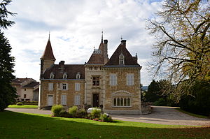
Ambronay Abbey
Church in Ain, France
Distance: Approx. 225 meters
Latitude and longitude: 46.00656,5.36179
Ambronay Abbey (French: Abbaye Notre-Dame d'Ambronay; Abbey of Our Lady, Ambronay) is a Benedictine abbey, founded in the 11th century by Barnard de Romans, which stands in the commune of Ambronay in the Ain department, in the Auvergne-Rhône-Alpes region.

Saint-Jean-le-Vieux, Ain
Commune in Auvergne-Rhône-Alpes, France
Distance: Approx. 3551 meters
Latitude and longitude: 46.0294,5.39
Saint-Jean-le-Vieux (French pronunciation: [sɛ̃ ʒɑ̃ lə vjø] ) is a commune in the Ain department in the Auvergne-Rhône-Alpes region in Eastern France.

Canton of Ambérieu-en-Bugey
Canton in Auvergne-Rhône-Alpes, France
Distance: Approx. 4656 meters
Latitude and longitude: 45.96305556,5.35416667
The canton of Ambérieu-en-Bugey is an administrative division of the Ain department, eastern France. Its borders were modified at the French canton reorganisation which came into effect in March 2015. Its seat is located in Ambérieu-en-Bugey.

Ambérieu-en-Bugey Air Base
Airport in Ambérieu-en-Bugey, France
Distance: Approx. 3188 meters
Latitude and longitude: 45.98722222,5.32833333
Ambérieu-en-Bugey Air Base (French: Détachement Air 278 Ambérieu-en-Bugey) (ICAO: LFXA) is a front-line French Air and Space Force (French: Armée de l'air et de l'espace or ALA) base located approximately 5 km north-northwest of Ambérieu-en-Bugey, in the Ain department of the Rhône-Alpes region in eastern France.
Ambronay Festival
Distance: Approx. 200 meters
Latitude and longitude: 46.0064,5.3611
The Ambronay Festival is a French opera festival and early music festival. The festival has been running in October for 30 years and previously produced recordings with labels such as the Auvidis label. 7 of 14 early recordings were with Jordi Savall.

Battle of Varey
14th century battle in France
Distance: Approx. 4975 meters
Latitude and longitude: 46.00777778,5.42527778
The Battle of Varey took place on 7 August 1325 in what is now the commune of Saint-Jean-le-Vieux, in the French department of Ain. It was between troops of the Count of Savoy and the Dauphin of Viennois as part of an ongoing war between the two neighbouring provinces.
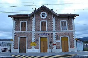
Ambronay—Priay station
Distance: Approx. 1927 meters
Latitude and longitude: 46.0116,5.3383
Ambronay—Priay station (French: Gare de Abronay—Priay) is a French railway station located in commune of Ambronay, Ain department in the Auvergne-Rhône-Alpes region. As its name suggests, the station also serves the nearby commune of Priay. It is located at kilometric point (KP) 61.274 on the Mâcon—Ambérieu railway.
Weather in this IP's area
broken clouds
28 Celsius
28 Celsius
27 Celsius
30 Celsius
1014 hPa
46 %
1014 hPa
984 hPa
10000 meters
3.05 m/s
5.58 m/s
220 degree
70 %
06:15:21
21:14:32