Country:
 Great Britain
Region:
City:
Latitude and Longitude:
Postal Code:
Time Zone:
language:
User-Agent:
Proxy IP:
Blacklist:
IP information under different IP Channel
ip-api
Country
IPinfo
Country
MaxMind
Country
Luminati
138.38.254.197Country
GBRegion
eng
City
bath
ASN
Time Zone
Europe/London
ISP
Jisc Services Limited
Latitude
Longitude
Postal
db-ip
Country
ipdata
Country
Popular places and events near this IP address

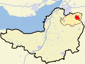
Bath, Somerset
City in Somerset, England
Distance: Approx. 242 meters
Latitude and longitude: 51.38,-2.36
Bath (RP: ; local pronunciation: [ba(ː)θ]) is a city in the ceremonial county of Somerset, England, known for and named after its Roman-built baths. At the 2021 Census, the population was 94,092. Bath is in the valley of the River Avon, 97 miles (156 km) west of London and 11 miles (18 km) southeast of Bristol.
Bath (UK Parliament constituency)
Parliamentary constituency in the United Kingdom
Distance: Approx. 242 meters
Latitude and longitude: 51.38,-2.36
Bath is a constituency in the House of Commons of the Parliament of the United Kingdom represented by Wera Hobhouse of the Liberal Democrats. Perhaps its best-known representatives have been the two with international profiles: William Pitt the Elder (Prime Minister 1766–1768) and Chris Patten, the last Governor of Hong Kong (1992-1997). It has the joint shortest name of any constituency in the current Parliament, with 4 letters, the same as Hove.

Bath Spa railway station
British railway station in Bath, England
Distance: Approx. 193 meters
Latitude and longitude: 51.3775,-2.3564
Bath Spa railway station is the principal station serving the city of Bath in Somerset, England. It is on the Great Western Main Line, 106 miles 71 chains (106.89 mi; 172.0 km) down the line from the zero point at London Paddington between Chippenham to the east and Oldfield Park to the west. It is the busiest station in Somerset, and the second busiest station in South West England after Bristol Temple Meads.

Heart Bath
Radio station in Bristol
Distance: Approx. 109 meters
Latitude and longitude: 51.3782,-2.3576
Heart 103 (formerly GWR Radio Bath and GWR FM Bath) was an Independent Local Radio station serving Bath in Somerset, England, broadcasting on 103 MHz FM, on DAB Digital radio and online.
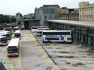
Bath bus station
Bus station in Somerset, England
Distance: Approx. 0 meters
Latitude and longitude: 51.3779,-2.3591
Bath bus station serves as part of an integrated transport interchange for the city of Bath, Somerset, England. The Manvers Street bus station opened in 1958 and operated until 2009 when it was replaced by the new bus station in Dorchester Street as part of the Southgate regeneration programme. The bus station is managed by First West of England.
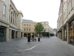
SouthGate, Bath
Shopping centre in Bath, Somerset, England
Distance: Approx. 96 meters
Latitude and longitude: 51.3786,-2.3583
SouthGate is a shopping centre in Bath, Somerset, England, It is home to over fifty shops, ten restaurants, 99 homes and an 860-space underground car park. It replaced a shopping centre which was demolished in 2007. The new centre developed by Multi Corporation UK is more than double the size of the previous space and provides 37,000 square metres of retail space, 3,500 m2 of leisure space, 2,300 m2 of restaurant space plus 99 residential units.

Stall Street, Bath
Historic site in Somerset, England
Distance: Approx. 272 meters
Latitude and longitude: 51.38027778,-2.36
Stall Street in Bath, Somerset, England was built by John Palmer between the 1790s and the first decade of the 19th century. The buildings which form an architectural group have listed building status and are now occupied by shops and offices. The street includes the side of the Grand Pump Room and the attached north and south colonnades.
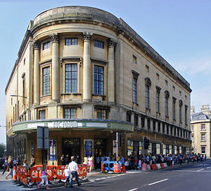
The Forum, Bath
Historic site in Somerset, England
Distance: Approx. 128 meters
Latitude and longitude: 51.37861111,-2.36055556
The Forum was built as an art deco cinema in Bath, Somerset, England, in 1934, and was designated as a Grade II* listed building on 28 May 1986. The building closed as a cinema in 1969, and has subsequently been used as a dancing school, a bingo hall, a church and a large event space for concerts and stand-up comedy. Its main auditorium has 1,600 seats, making it Bath's largest event venue.
Old Orchard Street Theatre
Former threatre turned Church turned Masonic Hall
Distance: Approx. 251 meters
Latitude and longitude: 51.38,-2.35777778
The Old Orchard Street Theatre in Bath, Somerset, England was built as a provincial theatre before becoming a Roman Catholic Church and since 1865 has been a Masonic Hall. It is a Grade II listed building.
Abbey, Bath
Human settlement in England
Distance: Approx. 242 meters
Latitude and longitude: 51.38,-2.36
Abbey was an electoral ward covering the centre of Bath, England. It was abolished as part of the boundary changes effected at the elections held on 2 May 2019. Abbey is rarely used as the name of an area of Bath, and was primarily used just for electoral purposes within the Bath and North East Somerset unitary authority; it elected two councillors.

Timeline of Bath, Somerset
History
Distance: Approx. 242 meters
Latitude and longitude: 51.38,-2.36
The following is a timeline of the history of the city of Bath, Somerset, England.
Bath power station
Former power station in England
Distance: Approx. 20 meters
Latitude and longitude: 51.37777778,-2.35888889
Bath power station supplied electricity to the City of Bath and the wider area from 1890. The station was originally built and operated by the City of Bath Electric Lighting and Engineering Company Limited. The power station was on a site in Dorchester Street adjacent to the Old Bridge over the River Avon.
Weather in this IP's area
clear sky
19 Celsius
18 Celsius
19 Celsius
20 Celsius
1012 hPa
52 %
1012 hPa
1009 hPa
10000 meters
3.28 m/s
5.16 m/s
44 degree
03:00:00
13:00:00
The latest IP detection test
- 112.245.112.72
- 5.173.116.163
- 62.158.150.10
- 223.130.90.110
- 229.234.235.133
- 206.56.177.9
- 171.70.86.253
- 186.150.96.127
- 126.95.215.38
- 161.183.141.77