Country:
 Mexico
Region:
City:
Latitude and Longitude:
Postal Code:
Time Zone:
language:
User-Agent:
Proxy IP:
Blacklist:
IP information under different IP Channel
ip-api
Country
IPinfo
Country
MaxMind
Country
Luminati
148.238.50.251Country
MXASN
Time Zone
America/Mexico_City
ISP
Alestra, S. de R.L. de C.V.
Latitude
Longitude
Postal
db-ip
Country
ipdata
Country
Popular places and events near this IP address
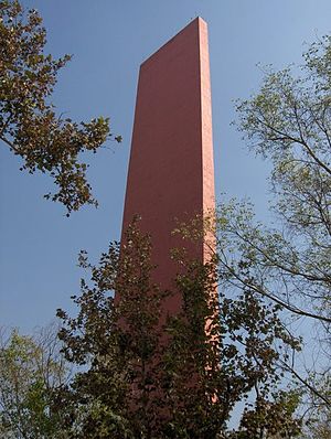
Faro del Comercio
Monument in Mexico
Distance: Approx. 672 meters
Latitude and longitude: 25.66619444,-100.31002778
Faro del Comercio is a monument designed by the accomplished Mexican architect Luis Barragán and constructed in 1984 by architect Raúl Ferrera. It is a recognizable sight in Monterrey among many other modern manmade landmarks, such as Neptune's Fountain (Fuente de la Vida), the Monterrey City Hall, the Papal Bridge (El Puente del Papa), and the Bridge of Unity (Puente de la Unidad) in San Pedro, connecting that municipality to Monterrey. These sites are intended on one hand to complement the city's few remaining traditional landmarks, such as, the Bishopric Palace (Palacio del Obispado) and Museum, the City's Cathedral (Catedral Metropolitana de Nuestra Señora de Monterrey), the Central Post Office (old Monterrey City Hall), and the State of Nuevo León Government building, on the north end of the Macroplaza.
El Puente del Papa
Bridge in Nuevo León, Mexico1
Distance: Approx. 349 meters
Latitude and longitude: 25.66361111,-100.31611111
El puente del Papa (The Pope's Bridge) is a bridge located in Monterrey, Nuevo León, Mexico, across the usually dry Río Santa Catarina. It took its name when Pope John Paul II offered a Catholic mass over the bridge. A flea market by the same name used to install itself under the bridge during weekends, but after hurricane "Alex" struck the city, among many things, there was a shift in the way traffic was directed and the flea market ceased to exist.

Roman Catholic Archdiocese of Monterrey
Latin Catholic jurisdiction in Mexico
Distance: Approx. 683 meters
Latitude and longitude: 25.6656,-100.31
The Archdiocese of Monterrey (Latin: Archidioecesis Monterreyensis) is a Latin Church ecclesiastical territory or archdiocese of the Catholic Church located in Monterrey, Nuevo León, Mexico. The Archdiocese of Monterrey is a metropolitan see; its suffragan dioceses are the Ciudad Victoria, Linares, Matamoros, Nuevo Laredo, Piedras Negras, Saltillo and Tampico.
Macroplaza
Town square or plaza in Monterrey, Mexico
Distance: Approx. 732 meters
Latitude and longitude: 25.66861111,-100.30972222
The Macroplaza or La Gran Plaza is a town square or plaza located in the heart of the city of Monterrey, Mexico. The Macroplaza is the fifth-largest plaza in the world and the largest Plaza in Mexico. It has an extension of 400,000 square metres consisting of various monuments, smaller plazas and gardens.
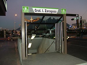
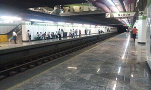
General I. Zaragoza metro station
Monterrey metro station
Distance: Approx. 655 meters
Latitude and longitude: 25.66777778,-100.31027778
General I. Zaragoza (Spanish: Estación General I. Zaragoza or Terminal Zaragoza) is a station on Lines 2 and 3 of the Monterrey Metro. It is located in Monterrey, on the heart of the Macroplaza. The station was opened on 30 November 1994 as the eastern terminus of the inaugural section of Line 2, between General Anaya and Zaragoza.
Fundadores metro station
Monterrey metro station
Distance: Approx. 730 meters
Latitude and longitude: 25.67267,-100.3197
The Fundadores Station (Spanish: Estación Fundadores) is a station on Line 2 of the Monterrey Metro. It is located in the intersection of 15 de Mayo street and Cuauhtémoc Avenue in the Monterrey centre. The station was opened on 30 November 1994 as part of the inaugural section of Line 2, between General Anaya and Zaragoza.

Padre Mier metro station
Monterrey metro station
Distance: Approx. 274 meters
Latitude and longitude: 25.66888,-100.31544
The Padre Mier Station (Spanish: Estación Padre Mier) is a station on Line 2 of the Monterrey Metro. It is located in the intersection of Padre Mier street and Juarez Avenue in the Monterrey centre. The station was opened on 30 November 1994 as part of the inaugural section of Line 2, between General Anaya and Zaragoza.

Museo de Arte Contemporáneo de Monterrey
Contemporary Art museum in Nuevo León, México
Distance: Approx. 719 meters
Latitude and longitude: 25.669,-100.31
Museo de Arte Contemporáneo de Monterrey (English: Museum of Contemporary Art, Monterrey), abbreviated as MARCO, is a major contemporary art museum, located in the city of Monterrey, in Nuevo León state of northeastern Mexico. MARCO organizes major exhibitions with regional and international contemporary artists. The museum is in the Centro district of Monterrey, adjacent to the Macroplaza and to the Barrio Antiguo district.

Barrio Antiguo
Distance: Approx. 966 meters
Latitude and longitude: 25.66684444,-100.30706944
Popularly known as the Barrio Antiguo (Spanish old quarter) comprise what is preserved from the historical quarter of the city of Monterrey, Nuevo León, Mexico. Currently located next to the Government Palace and the Macroplaza, it originally covered a larger space from the Santa Catarina River to 5 de Mayo Street, south to north, and from Mina Street to Roble Street (nowadays Avenida Benito Juárez), east to west. Most of the buildings now preserved are from the Spanish Colonial period and from the last years of the 19th century.
Universidad Metropolitana de Monterrey
Distance: Approx. 904 meters
Latitude and longitude: 25.6734,-100.3116
Universidad Metropolitana de Monterrey is a private university founded in the late 1980s, located in the Metropolitan area of Monterrey, Mexico.
Universidad Regiomontana
Distance: Approx. 723 meters
Latitude and longitude: 25.671,-100.3221
The Universidad Regiomontana (known by its shortened name U-ERRE, and previously by the abbreviation UR) is an institution of higher education in Monterrey, México. This university has its origin in the Instituto Modelo de Educación (Model Education Institute), which was converted into a university by Eduardo Elizondo, a former governor of Nuevo León. In 1974 a group of entrepreneurs bought the university: Rogelio Sada Zambrano, Bernardo Garza Sada, Eugenio Garza Lagüera, Andrés Marcelo Sada, Hernán Rocha, Jorge Garza, Alfonso Garza, Rodolfo Barrera, Manuel Llaguno, Humberto Lobo, Alberto Santos de Hoyos, and Alberto Fernández Ruiloba.
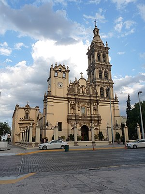
Monterrey Cathedral
Church in Monterrey, Mexico
Distance: Approx. 703 meters
Latitude and longitude: 25.6656,-100.3098
The Metropolitan Cathedral of Our Lady of Monterrey (Spanish: Catedral Metropolitana de Nuestra Señora de Monterrey) also Monterrey Cathedral is the main Catholic church and home of the Archdiocese of Monterrey. It is located in the capital of the state of Nuevo León in Mexico. The building has a central nave in the shape of a Latin cross flanked by niches chapels.
Weather in this IP's area
clear sky
34 Celsius
33 Celsius
34 Celsius
34 Celsius
1009 hPa
32 %
1009 hPa
950 hPa
10000 meters
2.75 m/s
2.98 m/s
72 degree
7 %
05:00:00
05:00:00
The latest IP detection test
- 240.195.190.47
- 160.114.248.242
- 22.180.195.93
- 167.80.134.69
- 161.232.62.127
- 214.51.65.134
- 88.165.138.196
- 122.251.101.171
- 170.252.214.246
- 55.220.67.89