Country:
 Japan
JapanRegion:
City:
Latitude and Longitude:
Postal Code:
Time Zone:
language:
User-Agent:
Proxy IP:
Blacklist:
IP information under different IP Channel
ip-api
Country
IPinfo
Country
MaxMind
Country
Luminati
157.13.32.218Country
JPASN
Time Zone
Asia/Tokyo
ISP
Research Organization of Information and Systems, National Institute of Informatics
Latitude
Longitude
Postal
db-ip
Country
ipdata
Country
Popular places and events near this IP address
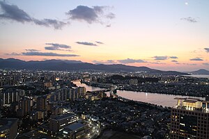
Fukuoka
Designated city in Kyushu, Japan
Distance: Approx. 784 meters
Latitude and longitude: 33.59,130.40166667
Fukuoka (Japanese: 福岡市, Fukuoka-shi, [ɸɯ̥kɯokaꜜɕi] ) is the sixth-largest city in Japan and the capital city of Fukuoka Prefecture, Japan. The city is built along the shores of Hakata Bay, and has been a center of international commerce since ancient times. The area has long been considered the gateway to the country, as it is the nearest point among Japan's main islands to the Asian mainland.

Fukuoka–Kitakyushu
Metropolitan area in Japan
Distance: Approx. 22 meters
Latitude and longitude: 33.5833,130.4
Fukuoka-Kitakyushu Greater Metropolitan Region (福岡・北九州大都市圏, Fukuoka Kitakyūshū Daitoshiken) is the most common name given to the region comprising the metropolitan areas of the cities of Fukuoka and Kitakyushu in Fukuoka Prefecture, Japan and in between. Alternate names are many, including Kitakyushu-Fukuoka Greater Metropolitan Region (北九州・福岡大都市圏), Northern Part of Kyushu Greater Metropolitan Region (北部九州大都市圏) One reason for complications in naming is because the whole region itself was once referred to as "Kitakyushu", which had become ambiguous after the city merger in 1963 which created the city by the same name. These cities may be referred to separately, but often are lumped together since they are close and lie in the same prefecture.
Seinan Gakuin University Biblical Botanical Garden
Distance: Approx. 26 meters
Latitude and longitude: 33.58333333,130.4
The Seinan Gakuin University Biblical Botanical Garden (西南学院大学聖書植物園, Seinan Gakuin Daigaku Seisho Shokubutsuen) is a Biblical garden, one of a number botanical gardens located across the campus of Seinan Gakuin University, Nishijin 6-2-92, Sawara-ku, Fukuoka, Fukuoka, Japan. It is open daily. The garden that contains about 80 plants mentioned in the Bible, with labels in the Hebrew, Greek, Latin, English, and Japanese, as well as a reference to the Biblical passage in which the plant is mentioned.
Roman Catholic Diocese of Fukuoka
Roman Catholic diocese in Japan
Distance: Approx. 26 meters
Latitude and longitude: 33.58333333,130.4
The Diocese of Fukuoka (Latin: Dioecesis Fukuokaensis, Japanese: カトリック福岡教区) is a Latin Church diocese of the Catholic Church located in Fukuoka in the ecclesiastical province of Nagasaki 長崎 in Japan.
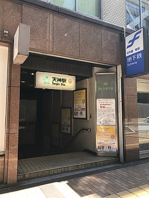
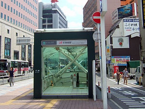
Tenjin Station
Metro station in Fukuoka, Japan
Distance: Approx. 924 meters
Latitude and longitude: 33.5913747,130.3992458
Tenjin Station (天神駅, Tenjin-eki) is a subway station located in Chūō-ku, Fukuoka, Japan. Its station symbol is 5 green dots arranged in a circle, representing a plum blossom, it is Tenmangū (a.k.a.Tenjin)'s symbol. The station is located directly under Meiji-Street (明治通り, Meiji-dōri) in Tenjin, Fukuoka.

Nishitetsu Fukuoka (Tenjin) Station
Railway station in Fukuoka, Japan
Distance: Approx. 632 meters
Latitude and longitude: 33.58877778,130.39988889
Nishitetsu-Fukuoka (Tenjin) Station (西鉄福岡(天神)駅, Nishitetsu-Fukuoka (Tenjin)-eki) is a railway station in Chūō-ku, Fukuoka, operated by the private railway operator Nishi-Nippon Railroad, and has station number T01.
Tenjin-Minami Station
Metro station in Fukuoka, Japan
Distance: Approx. 589 meters
Latitude and longitude: 33.5881952,130.4017282
Tenjin-Minami Station (天神南駅, Tenjin-Minami-eki) is a subway station located in Chūō-ku, Fukuoka. It is connected to Tenjin Station and Nishitetsu Fukuoka (Tenjin) Station through the Tenjin Chikagai (天神地下街), an underground shopping street. The station symbol is children playing the "Tōryanse" game (similar to the London Bridge game).
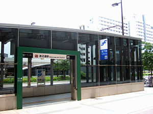
Watanabe-dōri Station
Metro station in Fukuoka, Japan
Distance: Approx. 468 meters
Latitude and longitude: 33.5841,130.4049
Watanabe-dōri Station (渡辺通駅, Watanabe-dōri-eki) is a train station located in Chūō-ku, Fukuoka. Watanabe-dōri(ja:渡辺通り) means Mr.Watanabe's avenue in Japanese, because to commemorate Yohatirō Watanabe (渡辺與八郎)) makes efforts to establish the tram line on here in 1911. This station's symbol mark is a tram that used to run here.
Yakuin-ōdōri Station
Metro station in Fukuoka, Japan
Distance: Approx. 492 meters
Latitude and longitude: 33.5803,130.3959
Yakuin-ōdōri Station (薬院大通駅, Yakuin-ōdōri-eki) is a train station located in Chūō-ku, Fukuoka. This station's symbol mark is an elephant's head and a flower because it's near the Zoo and Botanical Garden.
Asian Pacific Children's Convention
Distance: Approx. 883 meters
Latitude and longitude: 33.590988,130.401033
Asian Pacific Children's Convention (APCC Japanese: アジア太平洋こども会議・イン福岡) in Fukuoka, Japan, is a non-profit making organization which promotes peace and co-existence throughout the world under the theme "We are the BRIDGE: We connect dreams around the world". The organization's main event is the annual convention where over 300 children from Asia Pacific countries are invited to the city of Fukuoka in Japan with the intention of promoting inter cultural understanding and friendship. APCC was established in November 1988 and the inaugural convention was run as part of the Asia-Pacific Expo, "Yokatopia", the commemorative event to celebrate the 100th anniversary of the founding of Fukuoka City.

Fukuoka Kyuden Kinen Gymnasium
Distance: Approx. 814 meters
Latitude and longitude: 33.57666667,130.39583333
Fukuoka Kyuden Kinen Gymnasium (福岡市九電記念体育館, Fukuoka-shi Kyūden Kinen Taiikukan) is a sports and entertainment facility in Chuo-ku, Fukuoka, Japan. The building was opened by Kyushu Electric Power in 1964, and transferred to the city of Fukuoka in 2003, with the land loaned at no cost. It has a seating capacity of 1,992, with provision for a further 380 standing spectators.
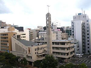
Our Lady of Victory Cathedral, Fukuoka
Church in Fukuoka, Japan
Distance: Approx. 912 meters
Latitude and longitude: 33.591,130.3974
The Our Lady of Victory Cathedral (Japanese: 聖母の勝利司教座聖堂) also called Daimyomachi Church is a religious building affiliated with the Catholic Church which is located in the city of Fukuoka, in the Asian country of Japan. It is dedicated to Our Lady of Victory. In 1896, a small wooden church was built on the site where the present church is located.
Weather in this IP's area
broken clouds
18 Celsius
18 Celsius
16 Celsius
21 Celsius
1017 hPa
82 %
10000 meters
1.03 m/s
75 %
03:00:00
17:00:00
The latest IP detection test
- 37.73.246.103
- 148.177.93.116
- 235.40.39.209
- 188.238.76.196
- 140.174.210.244
- 110.80.41.111
- 103.127.173.124
- 176.220.183.17
- 97.36.82.219
- 153.72.153.10