Country:
 USA
USARegion:
City:
Latitude and Longitude:
Time Zone:
Postal Code:
IP information under different IP Channel
ip-api
Country
IPinfo
Country
MaxMind
Country
Luminati
159.202.110.133Country
USASN
Time Zone
America/Chicago
Latitude
Longitude
Postal
db-ip
Country
ipdata
Country
Popular places and events near this IP address

Metropolitan Building (Minneapolis)
Structure in Minneapolis, MN, USA
Distance: Approx. 247 meters
Latitude and longitude: 44.97952778,-93.26666667
The Metropolitan Building, originally known as the Northwestern Guaranty Loan Building, is considered to be one of the most architecturally significant structures in the history of Minneapolis, Minnesota. It stood from 1890 until it was torn down starting in 1961 as part of major urban renewal efforts in the city that saw about 40% of the downtown district razed and replaced with new structures. At the time, the pending destruction of the Richardsonian Romanesque building provided a catalyst for historic preservation movements in the city and across the state.
Minneapolis Aquatennial
Annual outdoor event in Minneapolis, USA
Distance: Approx. 332 meters
Latitude and longitude: 44.9773,-93.2654
The Minneapolis Aquatennial is an annual outdoor event held in the U.S. city of Minneapolis, Minnesota, during the third full week of July. Originating in 1940, overshadowing the teamster picnics "to take the minds of Minneapolis citizens off past troubles and focus all minds throughout the state on some pleasant event", the Minneapolis Aquatennial celebrates the city's famous lakes, rivers, and streams. Advertised as The Best Days of Summer the festivities initially included some 200 events over 10 days (hence Aqua-ten-ial), at one point or another including the Aqua Follies, the Xcel Energy Sand Castle Competition, the Tom Thumb Milk Carton Boat Races, the Ultimate Wireless Co-ed Beach Volleyball Tournament, a sailing regatta, a tennis invitational, the Life Time Fitness Triathlon, many parades, among them the Minnegasco Torchlight Parade, the Master of International Management presents Shakespeare in the Park, Subway Block Party and the final Target Fireworks, one of the largest in the country, much larger than the city's Fourth of July celebration.
Walden University
American for-profit online university
Distance: Approx. 198 meters
Latitude and longitude: 44.98111111,-93.26555556
Walden University is a private for-profit online university headquartered in Minneapolis, Minnesota. It offers bachelor's, master's, doctoral, and specialist degrees. The university is owned by Adtalem Global Education, which purchased the university in August 2021.

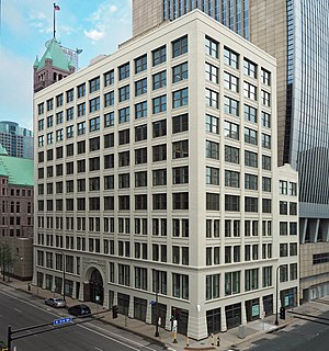
Minneapolis station (Milwaukee Road)
Historic railroad depot in Minneapolis, Minnesota
Distance: Approx. 113 meters
Latitude and longitude: 44.97972222,-93.26222222
The Chicago, Milwaukee, St. Paul and Pacific Depot Freight House and Train Shed (commonly referred to as the Milwaukee Road Depot), now officially named The Depot, is a historic railroad depot in downtown Minneapolis, Minnesota, United States. At its peak, the station served 29 trains per day.
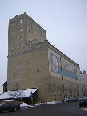
Ceresota Building
United States historic place
Distance: Approx. 307 meters
Latitude and longitude: 44.97972222,-93.25972222
Northwestern Consolidated Milling Company Elevator A also known as the Ceresota Elevator and "The Million Bushel Elevator" was a receiving and public grain elevator built by the Northwestern Consolidated Milling Company in 1908 in Minneapolis, Minnesota in the United States. The elevator may have been the largest brick elevator ever constructed (brick construction being relatively uncommon) and ran on electricity. The elevator was the source for the Crown Roller Mill and Standard Mill.

MacPhail Center for Music
Music school in Minneapolis, Minnesota, US
Distance: Approx. 266 meters
Latitude and longitude: 44.9794356,-93.260322
The MacPhail Center for Music is one of the nation's oldest and largest community-based music education centers. Located in the Mills District of Downtown East, Minneapolis, Minnesota, the school has over 16,000 students, providing instruction at more than 130 locations outside of its downtown Minneapolis facility on more than 35 instruments and in a variety of musical styles.
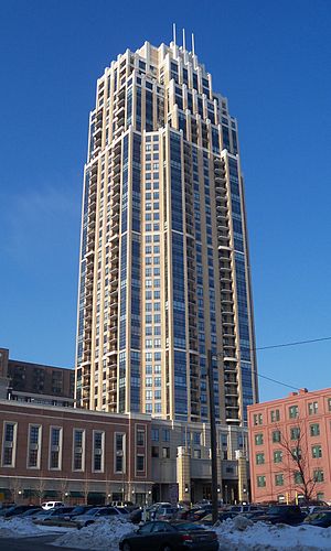
The Carlyle
Distance: Approx. 221 meters
Latitude and longitude: 44.98194444,-93.26305556
The Carlyle is a 469 ft (143 m) tall skyscraper in Minneapolis, Minnesota, USA, located at 100 Third Avenue South. Completed in 2007, The Carlyle has 41 floors and 249 units. It is the 14th-tallest building in Minneapolis, and the 2nd tallest residential building in Minnesota.
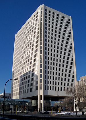
100 Washington Square
Distance: Approx. 215 meters
Latitude and longitude: 44.98111111,-93.26583333
100 Washington Square is a 332-ft (101 m) high-rise office building located in downtown Minneapolis. Construction started in 1979 and was completed in 1981. It covers 481,600 square feet and has 22 floors.

Churchill Apartments
Distance: Approx. 314 meters
Latitude and longitude: 44.98263889,-93.265
Churchill Apartments is a 310-ft (95 m) skyscraper in Minneapolis, Minnesota. It was built in 1981 and has 33 floors. It is the 38th-tallest building in the city.
Flour Exchange Building
United States historic place
Distance: Approx. 187 meters
Latitude and longitude: 44.97833333,-93.26388889
The Flour Exchange Building is an office building in downtown Minneapolis, Minnesota, United States, designed by architects Long and Kees, who also designed Minneapolis City Hall and the Lumber Exchange Building. Construction originally began in 1892, but halted abruptly in 1893 after only four floors had been built. This was due to the effects of the Panic of 1893.

United States Post Office (Minneapolis, Minnesota)
United States historic place
Distance: Approx. 39 meters
Latitude and longitude: 44.97985,-93.26404167
The United States Post Office building in Minneapolis, Minnesota, also known as the "Old" Federal Building, is a structure listed on the National Register of Historic Places. It was built from 1912 through 1915 and served as the main post office for Minneapolis until the present-day Minneapolis Post Office building was completed in 1936. Since then, it has housed a variety of federal offices.
Owamni
Restaurant in Minneapolis, Minnesota, U.S.
Distance: Approx. 289 meters
Latitude and longitude: 44.98111111,-93.26027778
Owamni by the Sioux Chef, or simply Owamni, is a Native American restaurant in downtown Minneapolis, Minnesota, that overlooks the Mississippi River. Owamni's majority Native American staff serves a menu made from indigenous ingredients such as game meats, corn, and wild plants. The restaurant does not serve ingredients that were introduced to the region by Europeans, including butter, dairy, sugar, black pepper, wheat, chicken, beef, and pork.
Weather in this IP's area
overcast clouds
18 Celsius
18 Celsius
17 Celsius
19 Celsius
1009 hPa
82 %
10000 meters
8.23 m/s
12.86 m/s
150 degree
100 %
20:00:00
13:00:00
The latest IP detection test
- 128.139.126.249
- 51.219.93.35
- 114.54.182.97
- 154.167.168.12
- 171.87.254.252
- 114.41.177.15
- 234.55.233.91
- 189.75.44.172
- 99.89.199.171
- 188.200.17.245