Country:
 USA
USARegion:
City:
Latitude and Longitude:
Postal Code:
Time Zone:
language:
User-Agent:
Proxy IP:
Blacklist:
IP information under different IP Channel
ip-api
Country
IPinfo
Country
MaxMind
Country
Luminati
170.219.81.185Country
USASN
Time Zone
America/Chicago
ISP
STATE-OF-FLA
Latitude
Longitude
Postal
db-ip
Country
ipdata
Country
Popular places and events near this IP address

DeSoto Site Historic State Park
Park in Tallahassee, Florida
Distance: Approx. 1191 meters
Latitude and longitude: 30.435323,-84.268811
DeSoto Site Historic State Park is a Florida state park located in Tallahassee, Florida. It consists of 5 acres (20,000 m2) of land near Apalachee Parkway, including the residence of former Governor John W. Martin. The site is intended to initiate research and education on nearly four centuries of recorded history beginning with Hernando de Soto's use of the site as a winter encampment in 1539.
Magnolia Heights Historic District
Historic district in Florida, United States
Distance: Approx. 1681 meters
Latitude and longitude: 30.44166667,-84.26833333
The Magnolia Heights Historic District is a U.S. historic district (designated as such on June 29, 1984) located in Tallahassee, Florida. The district runs from 701 through 1005 East Park Avenue, and Cadiz Street. It contains 25 historic buildings.
Smoky Hollow Historic District
Historic district in Florida, United States
Distance: Approx. 1506 meters
Latitude and longitude: 30.43638889,-84.27194444
The Smoky Hollow Historic District is a U.S. historic district (designated as such on October 27, 2000) located in Tallahassee, Florida. The district is bounded by East Lafayette Street, CSX RR tracks, Myers Park and Myers Park Lane. It contains 14 historic buildings and 3 structures.
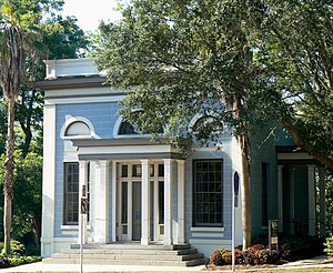
Union Bank (Tallahassee, Florida)
United States historic place
Distance: Approx. 2244 meters
Latitude and longitude: 30.4375,-84.28
The Union Bank of Tallahassee, Florida was established around 1830 and the bank building constructed for it in 1841. It is Florida's oldest surviving bank building. It is located at Apalachee Parkway and Calhoun Street and is now a museum and archive and research center for African American history.

Cascades Park (Tallahassee)
Park in Tallahassee, Florida
Distance: Approx. 1913 meters
Latitude and longitude: 30.43555556,-84.27722222
Cascades Park is a 24-acre (97,000 m2) park along the stream known as the St. Augustine Branch in Tallahassee, Florida, United States, south of the Florida State Capitol. It is a Nationally Registered Historic Place because it influenced the territorial government's choice of the capital city's location.

Caroline Brevard Grammar School
United States historic place
Distance: Approx. 2098 meters
Latitude and longitude: 30.43583333,-84.27916667
The Caroline Brevard Grammar School (also known as the Bloxham Building) is a historic school in Tallahassee, Florida. It is located at 727 South Calhoun Street and was designed by architect, William Augustus Edwards. On December 17, 1987, it was added to the U.S. National Register of Historic Places.
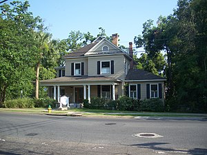
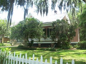
Gov. John W. Martin House
Historic house in Florida, United States
Distance: Approx. 827 meters
Latitude and longitude: 30.435,-84.26388889
The Gov. John W. Martin House (also known as Apalachee) is a historic house in Tallahassee, Florida. The residence of governor John W. Martin, it is located within the borders of DeSoto Site Historic State Park.

John Gilmore Riley House
Historic house in Florida, United States
Distance: Approx. 2122 meters
Latitude and longitude: 30.43916667,-84.2775
The John Gilmore Riley House is a historic home in Tallahassee, Florida. It is located at 419 East Jefferson Street. On August 1, 1978, it was added to the U.S. National Register of Historic Places.
Flavius C. Coles Farmhouse
United States historic place
Distance: Approx. 1863 meters
Latitude and longitude: 30.43111111,-84.27805556
The Flavius C. Coles Farmhouse is a historic site in Tallahassee, Florida. It is located at 411 Oakland Avenue. On January 7, 1992, it was added to the U.S. National Register of Historic Places.
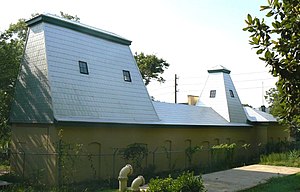
Old City Waterworks
United States historic place
Distance: Approx. 1987 meters
Latitude and longitude: 30.43555556,-84.27805556
The Old City Waterworks is a historic site in Tallahassee, Florida. It is located at East Gaines and South Gadsden Streets. On January 31, 1979, it was added to the US National Register of Historic Places.
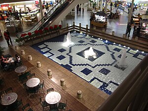
Governor's Square
Shopping mall in Tallahassee, Florida, United States
Distance: Approx. 1017 meters
Latitude and longitude: 30.436937,-84.253561
Governor's Square is a super-regional shopping mall located on Apalachee Parkway in Tallahassee, Florida. Its two-level design was a first for northern Florida when it opened in 1979, and was for many years the newest of two enclosed malls in the Tallahassee area, the other being The Centre of Tallahassee, formerly the Tallahassee Mall. The anchor stores are currently JCPenney and Dillard's along with two vacant spaces last occupied by Macy’s and Sears.

Tallahassee meridian
Meridian of longitude
Distance: Approx. 1870 meters
Latitude and longitude: 30.43447778,-84.27722222
The Tallahassee meridian, in longitude 84° 16′ 37.59″ west from the prime meridian at Greenwich, runs north and south from the initial point on the base line at Tallahassee, in latitude 30° 26′ 04.12″ north, and as a principal meridian governs the surveys in Florida and Alabama as part of the Public Land Survey System. The "Tallahassee meridian" survey monument (see survey marker) is located at the intersection of these lines of longitude and latitude (the longitude line being the "Tallahassee meridian" and the latitude line being the "Tallahassee Parallel" or "Tallahassee Base Line"). This survey monument serves as the initial point for U.S. government surveys in the state of Florida.
Weather in this IP's area
overcast clouds
27 Celsius
27 Celsius
25 Celsius
28 Celsius
1015 hPa
70 %
10000 meters
3.6 m/s
20 degree
100 %
18:00:00
11:00:00
The latest IP detection test
- 160.79.134.79
- 244.63.75.188
- 180.37.59.169
- 106.178.157.122
- 133.248.168.1
- 137.53.159.190
- 100.228.124.218
- 163.105.57.232
- 85.119.243.179
- 36.111.254.185