Country:
 Peru
PeruRegion:
City:
Latitude and Longitude:
Postal Code:
Time Zone:
language:
User-Agent:
Proxy IP:
Blacklist:
IP information under different IP Channel
ip-api
Country
IPinfo
Country
MaxMind
Country
Luminati
190.42.180.133Country
PERegion
are
City
arequipa
ASN
Time Zone
America/Lima
ISP
Telefonica del Peru S.A.A.
Latitude
Longitude
Postal
db-ip
Country
ipdata
Country
Popular places and events near this IP address
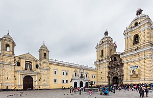
Basilica and Convent of San Francisco, Lima
Cultural heritage site in Peru
Distance: Approx. 264 meters
Latitude and longitude: -12.04549722,-77.02739444
The monumental complex of the Basilica and Convent of San Francisco of Lima, also known as "San Francisco el Grande" or "San Francisco de Jesús", is located in the Historic Center of Lima, Peru. This church together with the Sanctuary Nuestra Señora de la Soledad and the Church del Milagro set up one of the welcoming and artistic corners of Lima. Ramón Menéndez Pidal, Spanish philologist and scholar in this regard commented: "It is the largest and noblest monument that the conquest erected in these prodigious lands".

Government Palace, Peru
Building in Lima, Peru
Distance: Approx. 234 meters
Latitude and longitude: -12.0448,-77.0298
The Government Palace (Spanish: Palacio de Gobierno), also known as the House of Pizarro, is the seat of the executive branch of the Peruvian government, and the official residence of the president of Peru. The palace is a stately government building, occupying the northern side of the Plaza Mayor in Peru's capital city, Lima. Set on the Rímac River, the palace occupies the site of a very large huaca ("revered object") that incorporated a shrine to Taulichusco, the last kuraka (indigenous governor) of Lima.

Lima District
District in Lima, Peru
Distance: Approx. 5 meters
Latitude and longitude: -12.04333333,-77.02833333
Lima is a district of Lima Province in Peru. Lima district is the oldest in Lima Province and as such, vestiges of the city's colonial era remain today in the historic centre of Lima, which was declared a UNESCO World Heritage Site in 1988 and contains the foundational area known as Cercado de Lima (Spanish, 'Walled Lima').
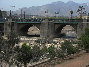
Puente de Piedra
Bridge
Distance: Approx. 164 meters
Latitude and longitude: -12.0434,-77.0298
The Bridge of Stone (Spanish: Puente de Piedra) is a bridge in Lima, Peru. It was built in 1608 by the architect Juan del Corral to link Lima with Rímac. It is the beginning of the jirón de la Unión, which was, in the first independent years of Peru, the most important road in the city.

Governorate of New Castile
Governorate of the Crown of Castile
Distance: Approx. 5 meters
Latitude and longitude: -12.04333333,-77.02833333
The Governorate of New Castile (Gobernación de Nueva Castilla, pronounced [ɡoβeɾnaˈθjon de ˈnweβa kasˈtiʎa]) was the gubernatorial region administered to Francisco Pizarro in 1529 by King Charles I of Spain, of which he was appointed governor. The region roughly consisted of modern Peru and was, after the foundation of Lima in 1535, divided. The conquest of the Inca Empire in 1531–1533, performed by Pizarro and his brothers set the basis for the territorial boundaries of New Castile.

Desamparados station
Cultural heritage site in Peru
Distance: Approx. 127 meters
Latitude and longitude: -12.0444,-77.0286
The Desamparados station (Spanish: Estación de Desamparados) is a railway station in Lima, Peru. It is situated on the left margin of the Rímac River, next to the Government Palace. The station was named after the Church of Our Lady of the Forsaken.
Governorate of New Toledo
Spanish Imperial colony
Distance: Approx. 5 meters
Latitude and longitude: -12.04333333,-77.02833333
The Governorate of New Toledo was a Spanish Governorate of the Crown of Castile formed from the previous southern half of the Inca Empire, stretching south into present day central Chile, and east into present day central Brazil. It was established by King Charles I of Spain in 1528. Diego de Almagro was the appointed Spanish royal governor.
Timeline of Lima
History of Lima
Distance: Approx. 5 meters
Latitude and longitude: -12.043333,-77.028333
The following is a timeline of the history of the city of Lima, Peru.
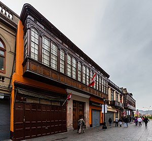
Casa de Aliaga
Building in Lima, Peru
Distance: Approx. 250 meters
Latitude and longitude: -12.0444,-77.0303
The Casa de Aliaga is a colonial-style building located in the historic centre of Lima, Peru. Its current owner is Gonzalo Jorge de Aliaga Ascenzo, VIII Count of San Juan de Lurigancho.
Parque de la Muralla
Park in Lima, Peru
Distance: Approx. 192 meters
Latitude and longitude: -12.0442,-77.0268
The Park of the Wall (Spanish: Parque de La Muralla) is a public park located in the central district of Lima, Peru. It was inaugurated in 2004. Within its extension is part of the former Walls of Lima.

Gate of Lima
Former landmark in Lima
Distance: Approx. 176 meters
Latitude and longitude: -12.04381775,-77.02982765
The Gate of Lima (Spanish: Portada de Lima; Arco del Puente) was a monumental gate in the historic centre of Lima, Peru. Built in 1700, it was located on the southern end of Trujillo Bridge, which connected the neighbourhood of San Lázaro with central Lima. It was burned down on April 10, 1879, by the Chilean baker Cornelio Granados, five days after the War of the Pacific formally began between Chile and Peru.
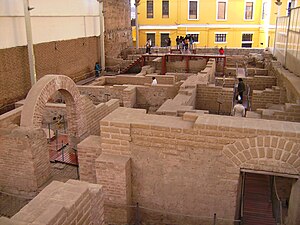
Bodega y Quadra Museum
Museum in Lima, Peru
Distance: Approx. 142 meters
Latitude and longitude: -12.04456,-77.02852
Bodega y Quadra Museum (Spanish: Museo de Sitio Bodega y Quadra) is a site museum located at second block of Jirón Áncash, in the historic centre of Lima, Peru. Located on the remains of a terrain that dates back to the Viceroyalty of Peru, it illustrates the daily life of people during the Spanish and Republican era of the city.
Weather in this IP's area
overcast clouds
22 Celsius
22 Celsius
17 Celsius
22 Celsius
982 hPa
71 %
10000 meters
2.06 m/s
280 degree
100 %
23:00:00
07:00:00
The latest IP detection test
- 250.4.223.68
- 43.232.199.37
- 138.11.191.110
- 165.244.118.238
- 209.161.171.40
- 81.56.225.154
- 240.40.67.51
- 59.234.75.135
- 71.156.86.166
- 12.220.103.192