Country:
 Netherlands
Region:
City:
Latitude and Longitude:
Postal Code:
Time Zone:
language:
User-Agent:
Proxy IP:
Blacklist:
IP information under different IP Channel
ip-api
Country
IPinfo
Country
MaxMind
Country
Luminati
194.121.124.104Country
NLASN
Time Zone
Europe/Amsterdam
ISP
KPN B.V.
Latitude
Longitude
Postal
db-ip
Country
ipdata
Country
Popular places and events near this IP address
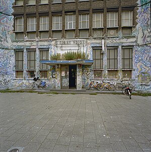
De Blauwe Aanslag
Demolished building in The Hague
Distance: Approx. 635 meters
Latitude and longitude: 52.07111,4.30111
De Blauwe Aanslag was a squat and self-managed social centre in the Dutch city of The Hague. The oldest part of the building was built in 1886. The large building formerly housed tax offices and was occupied in 1980.

Paard van Troje
Venue in The Hague, Netherlands
Distance: Approx. 644 meters
Latitude and longitude: 52.07472222,4.3075
Paard van Troje (Dutch for Trojan Horse), since 2016 known as PAARD, is a venue in The Hague, Netherlands founded in 1972 18 June with the support of the alderman of culture from The Hague. Currently located at the Prinsegracht.

Brouwersgracht RandstadRail station
Distance: Approx. 492 meters
Latitude and longitude: 52.07361111,4.30388889
Brouwersgracht is a RandstadRail stop in The Hague, Netherlands.
HMC Westeinde RandstadRail station
Distance: Approx. 429 meters
Latitude and longitude: 52.07277778,4.29944444
HMC Westeinde is a RandstadRail stop in The Hague, Netherlands.

Monstersestraat RandstadRail station
Distance: Approx. 588 meters
Latitude and longitude: 52.07305556,4.29222222
Monstersestraat is a RandstadRail stop in The Hague, Netherlands.
Nobelhuis
Distance: Approx. 620 meters
Latitude and longitude: 52.079118,4.306676
The Nobelhuis is a house located in the Nobelstraat in The Hague, the Netherlands. It is believed to be the oldest residential house in The Hague.
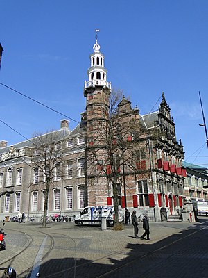
Old City Hall (The Hague)
Building in The Hague, Netherlands
Distance: Approx. 679 meters
Latitude and longitude: 52.07777778,4.30833333
The Old City Hall in The Hague is a Renaissance-style building on the Groenmarkt near the Grote Kerk. It is the former seat of the city's government, and remains a place where residents hold civic wedding ceremonies, and where the royal family register their family births. Other families do this at the current city hall located in the large white building on the Kalvermarkt, near the public library.
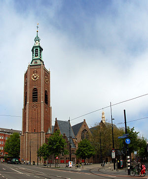
Grote or Sint-Jacobskerk (The Hague)
Church in The Hague, Netherlands
Distance: Approx. 594 meters
Latitude and longitude: 52.07722222,4.30722222
The Great Church or St. James' Church (in Dutch, Grote of Sint-Jacobskerk, Dutch pronunciation: [ˌɣroːtə ʔɔf sɪntˈjaːkɔpskɛrk]) is a landmark Protestant church in The Hague, Netherlands. The building is located on the Torenstraat, named for its high tower.

Politics and government of the Dutch Republic
Politics and Government of the Dutch Republic
Distance: Approx. 390 meters
Latitude and longitude: 52.08,4.3
The Dutch Republic existed from 1579 to 1795 and was a confederation of seven provinces, which had their own governments and were very independent, and a number of so-called Generality Lands. These latter were governed directly by the States-General (Staten-Generaal in Dutch), the federal government. The States-General were seated in The Hague and consisted of representatives of each of the seven provinces.
Queens Garden (restaurant)
Restaurant in The Hague, Netherlands
Distance: Approx. 566 meters
Latitude and longitude: 52.07955,4.30533611
Oueens Garden is a defunct restaurant located in the Parkhotel Den Haag in The Hague, Netherlands. It was a fine dining restaurant that was awarded one Michelin star in 1960 and retained that rating until 1971. The restaurant lost its star in 1972, after the restaurant changed course.

Zeeheldenkwartier
Distance: Approx. 648 meters
Latitude and longitude: 52.0823,4.2967
The Zeeheldenkwartier (Dutch pronunciation: [ˈzeːɦɛldə(ŋ)kʋɑrˌtiːr], literally Sea Heroes Quarter) is a neighbourhood in the Centrum district of The Hague, Netherlands. It has 11,205 inhabitants (as of 1 January 2013) and covers an area of 81.3 hectares (0.314 sq mi). It is bordered by the Carnegielaan, the Zeestraat, the Hoge Wal and the Prinsessewal to the north-east, the Veenkade to the south, the Waldeck Pyrmontkade to the south-west and the Laan van Meerdervoort to the Carnegielaan to the north.

Design Museum Dedel
Description House Dedel and Design Museum Dedel
Distance: Approx. 641 meters
Latitude and longitude: 52.07516389,4.30766944
Design Museum Dedel is a museum located in The Hague. The museum hosts thematic exhibitions of two-dimensional design, including graphic design, posters, wallpaper - and has included posters from the collection of the former Poster Museum in Hoorn and objects (including posters) from the collection of the ReclameArsenaal. The museum was opened on July 1, 2019 by Mrs.
Weather in this IP's area
clear sky
15 Celsius
15 Celsius
14 Celsius
17 Celsius
1010 hPa
92 %
10000 meters
2.06 m/s
350 degree
1 %
17:00:00
02:00:00
The latest IP detection test
- 111.102.132.160
- 68.64.44.9
- 110.226.10.85
- 151.64.141.37
- 55.219.51.92
- 128.155.251.18
- 66.93.131.70
- 209.176.54.73
- 144.52.86.231
- 208.171.251.190