Country:
 USA
USARegion:
City:
Latitude and Longitude:
Postal Code:
Time Zone:
language:
User-Agent:
Proxy IP:
Blacklist:
IP information under different IP Channel
ip-api
Country
IPinfo
Country
MaxMind
Country
Luminati
207.55.126.140Country
USRegion
or
City
monroe
ASN
Time Zone
America/Los_Angeles
ISP
PEAK
Latitude
Longitude
Postal
db-ip
Country
ipdata
Country
Popular places and events near this IP address

Marys River (Oregon)
River in Oregon, United States
Distance: Approx. 5123 meters
Latitude and longitude: 44.55555556,-123.26138889
Marys River is a 40-mile (64 km) tributary of the Willamette River in the U.S. state of Oregon. From its source at the confluence of its east and west forks near Summit, it flows generally southeast from the Central Oregon Coast Range to Corvallis.
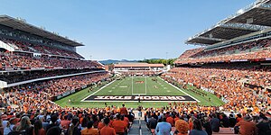
Reser Stadium
Outdoor athletic stadium in Corvallis, Oregon at Oregon State University
Distance: Approx. 4794 meters
Latitude and longitude: 44.559,-123.281
Reser Stadium is an outdoor athletic stadium in the northwest United States, on the campus of Oregon State University in Corvallis, Oregon. The home of the Oregon State Beavers of the Pac-12 Conference, it opened in 1953 as Parker Stadium and was renamed in 1999. Renovations for a new southwest grandstand decreased the seating capacity to 35,548 starting with the 2023 season.

Gill Coliseum
Building on the Oregon State University campus in Corvallis, Oregon, U.S.
Distance: Approx. 5050 meters
Latitude and longitude: 44.5613,-123.2805
Gill Coliseum is a multi-purpose indoor arena in the northwest United States, located on the campus of Oregon State University in Corvallis, Oregon. Opened in December 1949, the arena currently lists a seating capacity of 9,301 and is home to the Oregon State Beavers' basketball, wrestling, volleyball, and gymnastics teams. It is named after Amory T. "Slats" Gill, the Beavers' basketball coach for 36 seasons (from 1928 to 1964), who compiled a 599–392 (.604) record.
The LaSells Stewart Center
Building on the Oregon State University campus in Corvallis, Oregon, U.S.
Distance: Approx. 4855 meters
Latitude and longitude: 44.559128,-123.278964
The LaSells Stewart Center is the performing arts and conference center on the Oregon State University campus in Corvallis, Oregon, USA. The Stewart Family donated the money used to construct the center, and it is dedicated to the memory of LaSells Stewart. Facilities inside of The LaSells Stewart Center include; the Austin Auditorium, the Construction and Engineering Hall, the Giustina Gallery, the Agriculture Production Room/Agriculture Leaders Room/Agriculture Science Room, the Wells Fargo Room and the Weyerhaeuser Board Room. Giustina Gallery, located in the lobby of The LaSells Stewart Center, showcases artwork from local and national artists, as well as faculty and students of Oregon State University.
Kiger Island
Distance: Approx. 5108 meters
Latitude and longitude: 44.5125,-123.23416667
Kiger Island is a 2,200-acre (8.9 km2) island in Oregon formed by a fork between the Willamette River and the Booneville Channel. The island is located at 44°30′45″N 123°14′03″W. Kiger Island is south of Corvallis in southeastern Benton County, with the Linn County line following the contour of the eastern (river) side of the island. The only road to the island, SE Kiger Island Drive, is located off of Highway 99W (SW 3rd Street), just 2.5 miles south of downtown Corvallis.
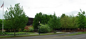
Philomath High School
School in Philomath, Benton, Oregon, United States
Distance: Approx. 5120 meters
Latitude and longitude: 44.537888,-123.356064
Philomath High School is a public high school in Philomath, Oregon, United States.

Corvallis Municipal Airport
Airport in Oregon, United States
Distance: Approx. 2381 meters
Latitude and longitude: 44.49722222,-123.28944444
Corvallis Municipal Airport (IATA: CVO, ICAO: KCVO, FAA LID: CVO) is five miles southwest of Corvallis, in Benton County, Oregon. The National Plan of Integrated Airport Systems for 2011–2015 categorized it as a general aviation facility. The airport offers full service and self serve fuel: 100LL and Jet A. Maintenance is available on the ramp; helicopter and fixed-wing flight instruction is available through Corvallis Aero Service.

Oregon State University College of Science
College within Oregon State University
Distance: Approx. 4923 meters
Latitude and longitude: 44.56,-123.28
Oregon State University's College of Science is a public academic institution operating as a member of Oregon State University, a public research university. The college of science consists of seven schools, offering nine undergraduate programs and supporting seven doctoral-granting programs and eight master's degree-granting programs. The college also supports the science discipline colleges and bachelor of science students by offering key undergraduate science courses required by their own curriculums.
Marine Corps Auxiliary Airfield Corvallis
Airport
Distance: Approx. 2381 meters
Latitude and longitude: 44.49722222,-123.28944444
Marine Corps Air Facility Corvallis is a former United States Marine Corps facility located four nautical miles (5 mi, 7 km) southwest of the central business district of Corvallis, a city in Benton County, Oregon, United States.
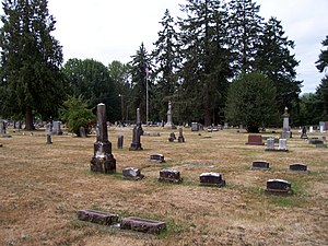
Crystal Lake Cemetery
Historic cemetery in Corvallis, Oregon, U.S.
Distance: Approx. 4882 meters
Latitude and longitude: 44.54777778,-123.25333333
Crystal Lake Cemetery, located in Corvallis, Benton County, Oregon, is listed on the National Register of Historic Places in June 2004. It is a burial ground that provides Corvallis residents with funeral and burial services. Although the tombs found at Crystal Lake Cemetery are not the oldest ones in Benton County, it is said that Crystal Lake Cemetery is one of the oldest cemetery in continuous use.

Oak Creek (Marys River tributary)
River in Oregon, United States
Distance: Approx. 4418 meters
Latitude and longitude: 44.55472222,-123.27805556
Oak Creek is a tributary, about 3.5 miles (5.6 km) long, of Marys River in Benton County in the U.S. state of Oregon. The stream descends from forested hills north of Corvallis through the northwest part of the city and across the campus of Oregon State University.
Mt. Union Cemetery
Cemetery in Benton County, Oregon
Distance: Approx. 3582 meters
Latitude and longitude: 44.5375573,-123.333615
Mt. Union Cemetery is located in Philomath, Oregon. The land for the Mt.
Weather in this IP's area
clear sky
4 Celsius
3 Celsius
3 Celsius
6 Celsius
1026 hPa
88 %
10000 meters
1.54 m/s
290 degree
01:00:00
16:00:00
The latest IP detection test
- 140.48.177.110
- 162.126.84.85
- 157.210.23.217
- 103.44.195.51
- 220.189.163.180
- 235.81.130.154
- 182.161.194.158
- 124.242.173.226
- 18.221.36.117
- 254.74.88.77