Country:
 Japan
JapanRegion:
City:
Latitude and Longitude:
Postal Code:
Time Zone:
language:
User-Agent:
Proxy IP:
Blacklist:
IP information under different IP Channel
Luminati
210.165.36.68Country
JPRegion
27
City
osaka
ASN
Time Zone
Asia/Tokyo
ISP
NTT PC Communications, Inc.
Latitude
Longitude
Postal
Popular places and events near this IP address
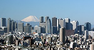
Tokyo
Capital and most populous city of Japan
Distance: Approx. 26 meters
Latitude and longitude: 35.68972222,139.69222222
Tokyo (; Japanese: 東京, Tōkyō, [toːkʲoː] ), officially the Tokyo Metropolis (東京都, Tōkyō-to), is the capital city of Japan and one of the most populous cities in the world, with a population of over 14 million residents as of 2023. The Greater Tokyo Area, which includes Tokyo and nearby six prefectures, is the most-populous metropolitan area in the world, with 40.8 million residents as of 2023. Located at the head of Tokyo Bay, Tokyo is part of the Kantō region on the central coast of Honshu, Japan's largest island.
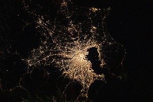
Greater Tokyo Area
Metropolitan area in Japan
Distance: Approx. 62 meters
Latitude and longitude: 35.68972222,139.69166667
The Greater Tokyo Area is the most populous metropolitan area in the world, consisting of the Kantō region of Japan (including Tokyo Metropolis and the prefectures of Chiba, Gunma, Ibaraki, Kanagawa, Saitama, and Tochigi) as well as the prefecture of Yamanashi of the neighboring Chūbu region. In Japanese, it is referred to by various terms, one of the most common being Capital Region (首都圏, Shuto-ken). As of 2016, the United Nations estimates the total population at 38,140,000.

Tokyo subway sarin attack
1995 terrorist attack by Aum Shinrikyo
Distance: Approx. 58 meters
Latitude and longitude: 35.68944444,139.69166667
The Tokyo subway sarin attack (地下鉄サリン事件, Chikatetsu Sarin Jiken, "Subway Sarin Incident") was an act of domestic terrorism perpetrated on 20 March 1995, in Tokyo, Japan, by members of the cult movement Aum Shinrikyo. In five coordinated attacks, the perpetrators released sarin on three lines of the Tokyo Metro (then Teito Rapid Transit Authority) during rush hour, killing 13 people, severely injuring 50 (some of whom later died), and causing temporary vision problems for nearly 1,000 others. The attack was directed against trains passing through Kasumigaseki and Nagatachō, where the National Diet (Japanese parliament) is headquartered in Tokyo.
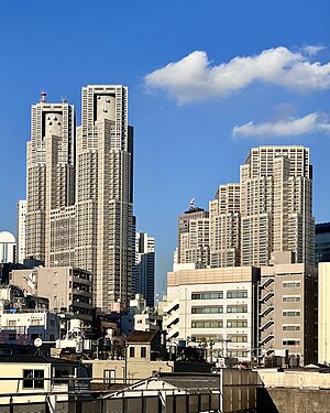
Tokyo Metropolitan Government Building
Building in Nishi-Shinjuku, Tokyo, Japan
Distance: Approx. 26 meters
Latitude and longitude: 35.68972222,139.69222222
The Tokyo Metropolitan Government Building (東京都庁舎, Tōkyō-to Chōsha), also referred to as the Tochō (都庁) for short, is the seat of the Tokyo Metropolitan Government, which governs the special wards, cities, towns, and villages that constitute the Tokyo Metropolis. Located in Shinjuku ward, the building was designed by architect Kenzo Tange. It consists of a complex of three structures, each taking up a city block.

Shinjuku Central Park
Park in Tokyo, Japan
Distance: Approx. 264 meters
Latitude and longitude: 35.69007,139.68947
Shinjuku Central Park or Shinjuku Chūō Park (新宿中央公園, Shinjuku chūō kōen) is a park in western Shinjuku, Tokyo, Japan. The park is bordered by Honnnan Dori and Kita Dori to the north, Junisha Dori to the west, Suido Dori or Minami Dori to the south, and Koen Dori to the east. The park is located directly in front of the Tokyo Metropolitan Government Building, and is surrounded by some of Tokyo's tallest buildings including the Hyatt Regency Tokyo, the Park Hyatt, and other hotels and office buildings.
Nishi-Shinjuku
Skyscraper district of Tokyo
Distance: Approx. 244 meters
Latitude and longitude: 35.68944444,139.695
Nishi-Shinjuku (西新宿, lit. 'West Shinjuku') is a skyscraper business district in Shinjuku, Tokyo, Japan. The region was previously called Tsunohazu (角筈).

Tokyo Metropolitan Government
Prefectural government of Tokyo, Japan
Distance: Approx. 45 meters
Latitude and longitude: 35.6895,139.6918
The Tokyo Metropolitan Government (東京都庁, Tōkyōto-chō) is the government of the Tokyo Metropolis. One of the 47 prefectures of Japan, the government consists of a popularly elected governor and assembly. The headquarters building is located in the ward of Shinjuku.

Tochōmae Station
Metro station in Tokyo, Japan
Distance: Approx. 136 meters
Latitude and longitude: 35.6907,139.6926
Tochōmae Station (都庁前駅, Tochōmae-eki, Metropolitan Government Station) is a subway station on the Toei Ōedo Line in Shinjuku, Tokyo, Japan, operated by the Tokyo subway operator Toei Subway.
47th All Japan Rugby Football Championship
Distance: Approx. 54 meters
Latitude and longitude: 35.689488,139.691706
The 2010 The All-Japan Rugby Football Championship (日本ラグビーフットボール選手権大会 Nihon Ragubi- Futtobo-ru Senshuken Taikai) starts on Feb 6th and finishes with the final on Feb 27th.
Shinjuku Oak Tower
Distance: Approx. 202 meters
Latitude and longitude: 35.69130556,139.6925
The Shinjuku Oak Tower (新宿オークタワー) is a skyscraper located in Shinjuku, Tokyo, Japan. Construction of the 184-metre, 38-storey skyscraper was finished in 2002.
Union of Japanese Scientists and Engineers
Distance: Approx. 282 meters
Latitude and longitude: 35.6918,139.691
The Union of Japanese Scientists and Engineers (JUSE) (Japanese: 日本科学技術連盟), was established in May 1946 by the Science and Technology Agency (now known as the Ministry of Education, Culture, Sports, Science and Technology) of the Government of Japan "To cope with the rapid advancement of society".
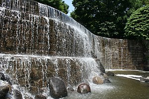
Shinjuku Niagara Falls
Distance: Approx. 255 meters
Latitude and longitude: 35.69009,139.68957
Shinjuku Niagara Falls is a fountain in Tokyo's Shinjuku Central Park, in Shinjuku, Japan. The Tokyo Weekender has described the water feature as "generously named".
Weather in this IP's area
clear sky
24 Celsius
24 Celsius
22 Celsius
27 Celsius
1019 hPa
48 %
10000 meters
10.29 m/s
180 degree
03:00:00
19:00:00