Country:
 South Korea
Region:
City:
Latitude and Longitude:
Postal Code:
Time Zone:
language:
User-Agent:
Proxy IP:
Blacklist:
IP information under different IP Channel
ip-api
Country
IPinfo
Country
MaxMind
Country
Luminati
210.182.245.93Country
KRASN
Time Zone
Asia/Seoul
ISP
LG DACOM Corporation
Latitude
Longitude
Postal
db-ip
Country
ipdata
Country
Popular places and events near this IP address

Deoksugung
Joseon-era palace in Seoul, South Korea
Distance: Approx. 208 meters
Latitude and longitude: 37.56618,126.97485
Deoksugung (Korean: 덕수궁) also known as Gyeongun-gung, Deoksugung Palace, or Deoksu Palace, is a walled compound of palaces in Seoul that was inhabited by members of Korea's royal family during the Joseon monarchy until the annexation of Korea by Japan in 1910. It is one of the "Five Grand Palaces" built by the kings of the Joseon dynasty and designated as a Historic Site. The buildings are of varying styles, including some of natural cryptomeria wood), painted wood, and stucco.
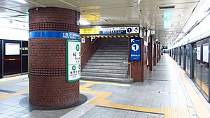
City Hall station (Seoul)
Train station in Seoul, South Korea
Distance: Approx. 177 meters
Latitude and longitude: 37.56472222,126.97694444
City Hall Station is a station on Seoul Subway lines 1 (Blue Line) and 2 (Green Line). As its name suggests, Seoul City Hall is located right next to the station. Deoksugung, a historic palace of the Joseon dynasty, is on the other side of the boulevard named Taepyeongno.
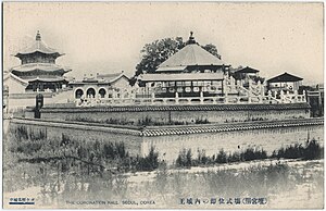
Hwangudan
Royal shrine in Seoul, South Korea
Distance: Approx. 272 meters
Latitude and longitude: 37.56505278,126.97985
Hwangudan (Korean: 환구단) was a shrine complex that still partially stands in Jung District, Seoul, South Korea. The complex consisted of two main buildings: a coronation site and Hwanggungu (황궁우; 皇穹宇; lit. Imperial Vault of Heaven).

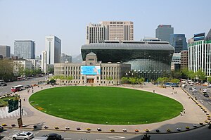
Seoul City Hall
Local government building in South Korea
Distance: Approx. 56 meters
Latitude and longitude: 37.56640556,126.97782222
Seoul City Hall (Korean: 서울특별시 청사) is a governmental building for the Seoul Metropolitan Government in South Korea, in charge of the administrative affairs of Seoul. It is located in Taepyeongno, Jung-gu, at the heart of Seoul. It is connected to City Hall Station (Seoul) on Seoul Subway Line 1, with access to Seoul Subway Line 2 from the same station.
Chohong Museum of Finance
Numismatics museum in Seoul, South Korea
Distance: Approx. 266 meters
Latitude and longitude: 37.5686,126.9764
The Chohong Museum of Finance is a numismatics museum in Seoul, South Korea. It was created in 1997 by the Chohung Bank, which called itself the oldest bank in Korea. The museum's collections were acquired by Shinhan Bank, which renamed the museum the Korea Financial History Museum.
Seoul Plaza
Distance: Approx. 112 meters
Latitude and longitude: 37.56555556,126.97805556
Seoul Plaza is a central plaza located in front of Seoul City Hall at Taepyeongno, Jung-gu in Seoul, South Korea. It was reopened on 1 May 2004, by Seoul Metropolitan Government, with the purpose of providing the public an open space. It is part of the city's plans for environmentally friendly renovation projects such as the Cheonggye Stream and Gwanghwamun Plaza.

Seoul Anglican Cathedral
Church in Seoul, South Korea
Distance: Approx. 145 meters
Latitude and longitude: 37.5671,126.9759
The Cathedral Church of St Mary the Virgin and St Nicholas (Korean: 대한성공회 서울주교좌대성당), or the Seoul Anglican Cathedral, is an Anglican cathedral in Downtown Seoul, South Korea. It is the mother church of both the Anglican Church of Korea and the Diocese of Seoul. Its location is adjacent to Deoksugung, the British Embassy in Seoul, Seoul Metropolitan Council, and Seoul City Hall.
Third Battle of Seoul
1950–1951 battle in the Korean War
Distance: Approx. 292 meters
Latitude and longitude: 37.56888889,126.97666667
The Third Battle of Seoul was a battle of the Korean War, which took place from December 31, 1950, to January 7, 1951, around the South Korean capital of Seoul. It is also known as the Chinese New Year's Offensive, the January–Fourth Retreat (Korean: 1•4 후퇴) or the Third Phase Campaign Western Sector (Chinese: 第三次战役西线; pinyin: Dì Sān Cì Zhàn Yì Xī Xiàn). In the aftermath of the major Chinese People's Volunteer Army (PVA) victory at the Battle of the Ch'ongch'on River, the United Nations Command (UN) started to contemplate the possibility of evacuation from the Korean Peninsula.
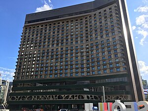
The Plaza Hotel Seoul
Hotel in Seoul, South Korea
Distance: Approx. 213 meters
Latitude and longitude: 37.56444444,126.97777778
THE PLAZA Seoul, Autograph Collection is situated in the heart of Seoul, to the south of Seoul Plaza.

Seoul Metropolitan Library
Library in South Korea
Distance: Approx. 56 meters
Latitude and longitude: 37.56640556,126.97782222
Seoul Metropolitan Library (Korean: 서울도서관) is a Metropolitan Library on Taepyeongno, Jung District, Seoul, South Korea. It faces the Seoul City Hall and Seoul Plaza, and is next to the City Hall Station on Seoul Subway Line 1.

Embassy of the United Kingdom, Seoul
Diplomatic mission in South Korea
Distance: Approx. 209 meters
Latitude and longitude: 37.56703528,126.97502306
The British Embassy in South Korea (Korean: 주한 영국 대사관) is the diplomatic mission of the United Kingdom to South Korea. The British Ambassador to South Korea is Colin Crooks, since March 2022.
Bumingwan
Historic building in Seoul, South Korea
Distance: Approx. 151 meters
Latitude and longitude: 37.5676,126.9767
Bumingwan (Korean: 부민관; Hanja: 府民館; MR: Pumin'gwan; Modified Hepburn: Fuminkan) is a historic building in Seoul, South Korea. It currently serves as a building for the Seoul Metropolitan Council. It was designated a Registered Cultural Heritage in 2002.
Weather in this IP's area
mist
16 Celsius
16 Celsius
15 Celsius
18 Celsius
1017 hPa
94 %
4500 meters
1.03 m/s
260 degree
51 %
21:00:00
06:00:00
The latest IP detection test
- 224.179.192.162
- 155.15.98.214
- 185.195.74.3
- 206.174.12.178
- 204.135.36.159
- 28.4.146.51
- 158.117.163.118
- 11.186.203.168
- 135.237.20.180
- 92.129.81.121