Country:
 USA
USARegion:
City:
Latitude and Longitude:
Postal Code:
Time Zone:
language:
User-Agent:
Proxy IP:
Blacklist:
IP information under different IP Channel
ip-api
Country
IPinfo
Country
MaxMind
Country
Luminati
23.91.215.57Country
USRegion
tx
City
baycity
ASN
Time Zone
America/Chicago
ISP
CABLEONE
Latitude
Longitude
Postal
db-ip
Country
ipdata
Country
Popular places and events near this IP address
Wharton, Texas
City in Texas, United States
Distance: Approx. 11 meters
Latitude and longitude: 29.31166667,-96.10277778
Wharton is a city in and the county seat of Wharton County, Texas, United States. This city is 60 mi (97 km) southwest of Houston. Its population was 8,832 at the 2010 census and 8,627 at the 2020 census.

Wharton County Junior College
Community college in Wharton, Texas, U.S.
Distance: Approx. 2254 meters
Latitude and longitude: 29.324642,-96.084935
Wharton County Junior College (WCJC) is a public community college with its main campus in Wharton, Texas. The college also has campuses in Richmond, Sugar Land, and Bay City. WCJC offers a range of postsecondary educational programs and services including associate degrees, certificates, and continuing-education courses.

20th Century Technology Museum
Distance: Approx. 340 meters
Latitude and longitude: 29.30930556,-96.10038889
The 20th Century Technology Museum is located in Wharton, Texas, United States, and displays examples of technology from the 20th century. The museum is a non-profit organization and opened its gallery in July 2005 on the first floor of the former Wharton County Jail, which was constructed in 1888. The museum's collection consists mostly of smaller items, such as radios, but also has a few experimental aircraft, including an ornithopter and a Rutan VariEze, which is displayed in front of the museum.
KANI
Radio station in Wharton, Texas
Distance: Approx. 4431 meters
Latitude and longitude: 29.32277778,-96.05888889
KANI (1500 AM) is a radio station broadcasting a Gospel format. Licensed to Wharton, Texas, United States, it serves the Houston, Texas area. The station is currently owned by Martin Broadcasting.
Congregation Shearith Israel (Wharton, Texas)
Former synagogue in Wharton, Texas, United States
Distance: Approx. 1245 meters
Latitude and longitude: 29.319179,-96.0932696
Congregation Shearith Israel was a Jewish Texan community in Wharton, Texas. This rural Texan community held Jewish services for over 100 years (1899-2002).
Wharton Regional Airport
Airport
Distance: Approx. 8115 meters
Latitude and longitude: 29.25416667,-96.15416667
Wharton Regional Airport (IATA: WHT, ICAO: KARM, FAA LID: ARM) is a public airport located five miles (8 km) southwest of the central business district of Wharton, a city in Wharton County, Texas, United States. It is owned by the City of Wharton. Many U.S. airports use the same three-letter location identifier for the FAA and IATA. However, this airport is assigned ARM by the FAA but has been assigned WHT from the IATA. Note that ARM was assigned to Armidale Airport in Armidale, New South Wales, Australia.
Glen Flora, Texas
Unincorporated community in Texas, United States
Distance: Approx. 9661 meters
Latitude and longitude: 29.3475,-96.19333333
Glen Flora is an unincorporated community in Wharton County, Texas, United States. According to the Handbook of Texas, the community had an estimated population of 210 in 2000. It is located within the Greater Houston metropolitan area.
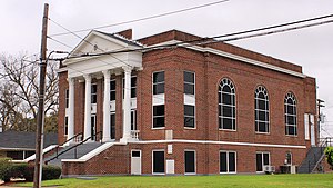
Old First Methodist Episcopal Church South
Historic church in Texas, United States
Distance: Approx. 409 meters
Latitude and longitude: 29.3125,-96.09861111
Old First Methodist Episcopal Church South is a historic church at 200 N. Fulton in Wharton, Texas. It was built in 1927 and added to the National Register in 1993.

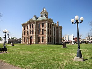
Wharton County Courthouse Historic Commercial District
Historic district in Texas, United States
Distance: Approx. 215 meters
Latitude and longitude: 29.31055556,-96.10083333
The Wharton County Courthouse Historic Commercial District is a 21-acre (8.5 ha) historic district in Wharton, Texas that was listed on the National Register of Historic Places in 1991. It includes works by architects Jules Leffland and Wyatt C. Hedrick and others. The NRHP listing included 46 contributing buildings and two contributing objects, as well as 31 non-contributing buildings and two non-contributing objects, on the blocks fronting on the courthouse square and on nearby blocks (see map on page 7 of NRHP document).

Burr, Texas
Unincorporated community in Texas, United States
Distance: Approx. 9249 meters
Latitude and longitude: 29.30805556,-96.0075
Burr, also known as Lawson's Corner or Kriegel Switch, is an unincorporated community in eastern Wharton County, in the U.S. state of Texas. The small community is situated on Farm to Market Road 1301 (FM 1301) to the east of the county seat at Wharton. The settlement was first established just before the Civil War, when two plantations were set up in the area.
Mackay, Texas
Unincorporated community in Texas, United States
Distance: Approx. 6503 meters
Latitude and longitude: 29.27,-96.14972222
Mackay is an unincorporated community in central Wharton County, in the U.S. state of Texas. The once thriving community is located on U.S. Route 59, (US 59) southwest of Wharton near Wharton Regional Airport. Mackay began as a railroad stop near a large ranch in 1881 and saw an influx of immigrants beginning in 1907.
Dinsmore, Texas
Unincorporated community in Texas, United States
Distance: Approx. 5100 meters
Latitude and longitude: 29.31722222,-96.05055556
Dinsmore is an unincorporated community in Wharton County, Texas, United States. According to the Handbook of Texas, the community had a population of 250 in the early 1990s. It is located within the Greater Houston metropolitan area.
Weather in this IP's area
broken clouds
27 Celsius
27 Celsius
26 Celsius
31 Celsius
1012 hPa
41 %
10000 meters
3.6 m/s
200 degree
75 %
21:00:00
18:00:00
The latest IP detection test
- 229.178.105.105
- 17.199.66.157
- 71.26.170.151
- 180.45.19.96
- 105.89.251.110
- 42.213.132.51
- 237.202.119.129
- 109.34.180.164
- 27.95.230.146
- 142.122.75.140