Country:
 Great Britain
Region:
City:
Latitude and Longitude:
Postal Code:
Time Zone:
language:
User-Agent:
Proxy IP:
Blacklist:
IP information under different IP Channel
ip-api
Country
IPinfo
Country
MaxMind
Country
Luminati
25.61.169.85Country
GBASN
Time Zone
Europe/London
Latitude
Longitude
Postal
db-ip
Country
ipdata
Country
Popular places and events near this IP address
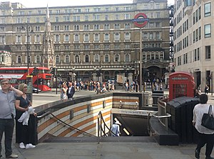
Charing Cross tube station
London Underground station
Distance: Approx. 84 meters
Latitude and longitude: 51.50805556,-0.12472222
Charing Cross (sometimes informally abbreviated as Charing +, Charing X, CHX or CH+) is a London Underground station at Charing Cross in the City of Westminster. The station is served by the Bakerloo and Northern lines and provides an interchange with Charing Cross mainline station. On the Bakerloo line it is between Piccadilly Circus and Embankment stations, and on the Charing Cross branch of the Northern line it is between Leicester Square and Embankment stations.

Charing Cross railway station
Central London railway terminus
Distance: Approx. 74 meters
Latitude and longitude: 51.508,-0.125
Charing Cross railway station (also known as London Charing Cross) is a central London railway terminus between the Strand and Hungerford Bridge in the City of Westminster. It is the terminus of the Southeastern Main Lines to Dover via Ashford and Hastings via Tunbridge Wells. All trains are operated by Southeastern, which provides the majority of commuter and regional services to south-east London and Kent.

Inner London
Inner boroughs of Greater London
Distance: Approx. 25 meters
Latitude and longitude: 51.508411,-0.125364
Inner London is the name for the group of London boroughs that form the interior part of Greater London and are surrounded by Outer London. With its origins in the bills of mortality, it became fixed as an area for statistics in 1847 and was used as an area of local government from 1855 to 1965 principally as the County of London or earlier as the Metropolitan Board of Works Area (metropolis). It now has two common definitions.
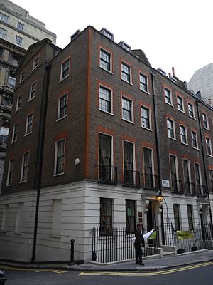
British Optical Association
UK organisation
Distance: Approx. 81 meters
Latitude and longitude: 51.5078,-0.1254
The British Optical Association (BOA) was founded in February 1895 as the first professional body for ophthalmic opticians (optometrists) in the world. The British Optical Association Museum and Library was founded in 1901; it retains the BOA name but is now part of the College of Optometrists, located in Craven Street, Charing Cross, central London.
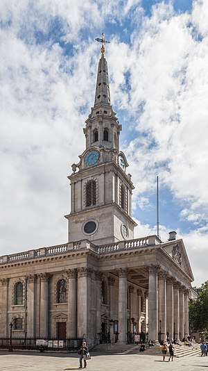
St Martin-in-the-Fields
Church in London, England
Distance: Approx. 96 meters
Latitude and longitude: 51.50888889,-0.12694444
St Martin-in-the-Fields is a Church of England parish church at the north-east corner of Trafalgar Square in the City of Westminster, London. Dedicated to Saint Martin of Tours, there has been a church on the site since at least the medieval period. This location, at that time, was farmlands and fields beyond the London wall.
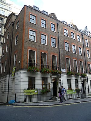
College of Optometrists
UK professional body
Distance: Approx. 73 meters
Latitude and longitude: 51.507865,-0.125428
The College of Optometrists is the professional, scientific and examining body for optometry in the United Kingdom, working for the public benefit. Their headquarters is at 41-42 Craven Street, London WC2, of which no 41 is a Grade II listed building.
Hungerford Hall
Distance: Approx. 43 meters
Latitude and longitude: 51.5082,-0.1253
Hungerford Hall was a lecture theatre built beside Hungerford Market near Charing Cross in London in 1851. It was used for public entertainments, including demonstrations of magic, mesmerism and optical illusions. It burned down in 1854, badly damaging the adjoining Hungerford Market.
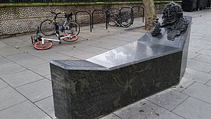
A Conversation with Oscar Wilde
Memorial sculpture in London by Maggi Hambling
Distance: Approx. 24 meters
Latitude and longitude: 51.50868,-0.12589
A Conversation with Oscar Wilde is an outdoor sculpture by Maggi Hambling in central London dedicated to Oscar Wilde. Unveiled in 1998, it takes the form of a bench-like green granite sarcophagus, with a bust of Wilde emerging from the upper end, with a hand clasping a cigarette.
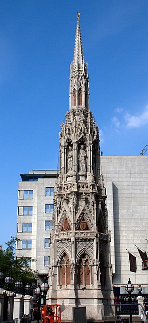
Queen Eleanor Memorial Cross
Historic site in Charing Cross railway station, London
Distance: Approx. 30 meters
Latitude and longitude: 51.5084,-0.1253
The Queen Eleanor Memorial Cross is a memorial to Eleanor of Castile erected in the forecourt of Charing Cross railway station, London, in 1864–1865. It is a fanciful reconstruction of the medieval Eleanor cross at Charing, one of twelve memorial crosses erected by Edward I of England in memory of his first wife. The Victorian monument was designed by Edward Middleton Barry, also the architect of the railway station, and includes multiple statues of Queen Eleanor by the sculptor Thomas Earp.

European Academy of Optometry and Optics
Distance: Approx. 70 meters
Latitude and longitude: 51.5079,-0.12539
The European Academy of Optometry and Optics (EAOO) is a membership organization for the development of optometry and optics in Europe. It aims to help in advancing scientific knowledge and learning for optometrists, opticians, and vision scientists, within Europe. The EAOO organizes an annual conference, held at venues around Europe.
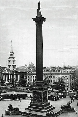
Morley's Hotel
Former hotel in London
Distance: Approx. 90 meters
Latitude and longitude: 51.5082,-0.1269
Morley's Hotel was a building which occupied the entire eastern side of London's Trafalgar Square, until it was demolished in 1936 and replaced with South Africa House. It was next to St Martin-in-the-Fields Church. It was designed by the architect George Ledwell Taylor, and originally developed as apartments.
Station Squabble
Digital photography
Distance: Approx. 4 meters
Latitude and longitude: 51.50853,-0.12574
Station Squabble is a digital photograph taken by Sam Rowley that won the Natural History Museum's Wildlife Photographer of the Year People's Choice Award, described by the BBC as an "annual, internationally famous WPY competition", on 12 February 2020. Two mice, which had been foraging separately on a platform in the London Underground, are depicted fighting over a crumb that they had found simultaneously. To capture the shot, Rowley spent a week overnight in the Underground system, according to the BBC, receiving "many strange looks from commuters", Rowley said, as he had to lie on various station platforms with his camera.
Weather in this IP's area
scattered clouds
18 Celsius
18 Celsius
17 Celsius
19 Celsius
1012 hPa
70 %
10000 meters
4.12 m/s
60 degree
40 %
09:00:00
11:00:00
The latest IP detection test
- 40.34.14.102
- 165.208.184.98
- 21.115.75.2
- 151.111.124.76
- 63.143.172.127
- 240.89.242.59
- 184.139.168.226
- 167.122.104.213
- 203.65.12.43
- 150.111.86.88