Country:
 Japan
JapanRegion:
City:
Latitude and Longitude:
Postal Code:
Time Zone:
language:
User-Agent:
Proxy IP:
Blacklist:
IP information under different IP Channel
ip-api
Country
IPinfo
Country
MaxMind
Country
Luminati
27.147.116.211Country
JPRegion
23
City
ichinomiya
ASN
Time Zone
Asia/Tokyo
ISP
ICC Corporation
Latitude
Longitude
Postal
db-ip
Country
ipdata
Country
Popular places and events near this IP address

Nagoya
Designated city in Chūbu, Japan
Distance: Approx. 545 meters
Latitude and longitude: 35.18333333,136.9
Nagoya (名古屋市, Nagoya-shi, [naꜜɡoja] ) is the largest city in the Chūbu region, the fourth-most populous city proper with a population of 2.3 million in 2020, and the principal city of the Chūkyō metropolitan area, which is the third-most populous metropolitan area in Japan with a population of 10.11 million. Located on the Pacific coast in central Honshu, it is the capital and most populous city of Aichi Prefecture, with the Port of Nagoya being Japan's largest seaport. In 1610, the warlord Tokugawa Ieyasu, a retainer of Oda Nobunaga, moved the capital of Owari Province from Kiyosu to Nagoya.

Aichi Prefectural Gymnasium
A multi-purpose gymnasium in Nagoya, Japan
Distance: Approx. 327 meters
Latitude and longitude: 35.18308611,136.90256111
Aichi Prefectural Gymnasium (愛知県体育館, Aichi-ken Taiikukan), also known as Dolphins Arena (ドルフィンズアリーナ, Dorufinzu Ariina), is a multi-purpose gymnasium in Nagoya, Japan, built in 1964.

Nagoyajo Station
Metro station in Nagoya, Japan
Distance: Approx. 19 meters
Latitude and longitude: 35.18153497,136.90537778
Nagoyajo Station (名古屋城駅, Nagoyajō-eki, lit. "Nagoya Castle Station") is an underground metro station located in Naka-ku, Nagoya, Aichi Prefecture, Japan operated by the Nagoya Municipal Subway. It is located 4.3 rail kilometers from the terminus of the Meijō Line at Kanayama Station.

Higashi Ōte Station
Railway station in Nagoya, Japan
Distance: Approx. 369 meters
Latitude and longitude: 35.1838,136.9083
Higashi Ōte Station (東大手駅, Higashiōte-eki) is a railway station in Naka-ku, Nagoya, Aichi Prefecture, Japan, operated by Meitetsu.

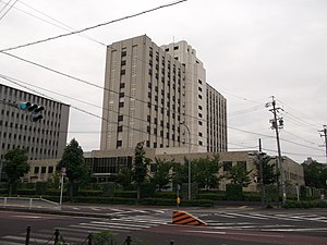
Nagoya City Hall
Distance: Approx. 79 meters
Latitude and longitude: 35.18144722,136.90636667
Nagoya City Hall (名古屋市役所, Nagoya Shiyakusho) is the city hall of the city of Nagoya, Japan. It is designed in the Imperial Crown style, a fusion Japanese and modern style. It survived the bombings of World War II and is registered as a Tangible Cultural Property of Japan.

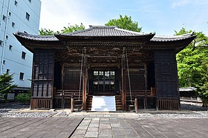
Nagoya City Archives
Distance: Approx. 437 meters
Latitude and longitude: 35.18135833,136.91030278
Nagoya City Archives (名古屋市市政資料館) is a historic building located in the city of Nagoya, central Japan. It was constructed in 1922 during the Taishō era, when western influences in architecture were increasingly fashionable in Japan. It was originally built as the Nagoya Court of Appeals building.

Aichi Prefectural Government Office
Distance: Approx. 170 meters
Latitude and longitude: 35.18022222,136.90669444
The Aichi Prefectural Government Office (愛知県庁 Aichi Kenchō) is the main building of the government of Aichi Prefecture. It is located in the city of Nagoya.

Nagoya Shrine
Shinto shrine in Japan
Distance: Approx. 682 meters
Latitude and longitude: 35.1775,136.89972222
The Nagoya Shrine (那古野神社, Nagoya-jinja) is a Shinto shrine located in Marunouchi in the Naka Ward in Nagoya, central Japan.

Aichi Gokoku Shrine
Shinto shrine in Nagoya, Japan
Distance: Approx. 569 meters
Latitude and longitude: 35.17944444,136.89972222
The Aichi Prefecture Gokoku Shrine is a Shinto shrine located in the Sannomaru compound, next to Nagoya Castle, in central Nagoya, Japan.
Nagoya Tōshō-gū
Distance: Approx. 708 meters
Latitude and longitude: 35.17755556,136.89930556
Nagoya Tōshō-gū (名古屋東照宮) is a Shinto shrine located in central Nagoya, Aichi Prefecture, Japan.
Nagoya Detention House
Detention facility in Nagoya, Japan
Distance: Approx. 408 meters
Latitude and longitude: 35.18218889,136.909875
Nagoya Detention House (名古屋拘置所, Nagoya Kōchisho) is a correctional facility in Higashi-ku, Nagoya. A part of the penal system of Japan, it is operated by the Ministry of Justice. One of Japan's seven execution chambers is in this facility.

Honkō-ji
Buddhist temple in Aichi Prefecture, Japan
Distance: Approx. 664 meters
Latitude and longitude: 35.18472222,136.89944444
Honkō-ji (本光寺) is a Buddhist temple belonging to the Sōtō sect of Japanese Zen located in the town of Kōta, Nukata District, Aichi Prefecture, Japan. The temple is noted for its hydrangea flowers in spring. Its main image is a statue of Shaka Nyōrai.
Weather in this IP's area
overcast clouds
27 Celsius
28 Celsius
22 Celsius
27 Celsius
1009 hPa
49 %
10000 meters
1.63 m/s
3.87 m/s
340 degree
95 %
07:00:00
06:00:00
The latest IP detection test
- 108.169.134.229
- 2.72.18.12
- 222.123.221.40
- 234.52.39.147
- 119.151.78.155
- 214.79.85.218
- 110.148.243.106
- 119.74.22.3
- 62.32.75.82
- 219.26.221.223