Country:
 Australia
Region:
City:
Latitude and Longitude:
Postal Code:
Time Zone:
language:
User-Agent:
Proxy IP:
Blacklist:
IP information under different IP Channel
Luminati
27.50.84.27Country
AURegion
vic
City
melbourne
ASN
Time Zone
Australia/Melbourne
ISP
Wholesale Services Provider
Latitude
Longitude
Postal
Popular places and events near this IP address
2moro Radio
Distance: Approx. 74 meters
Latitude and longitude: -33.867139,151.207114
2MORO is one of two full-time Arabic language radio stations in Sydney, Australia. It is broadcast locally on 1620 AM and has a national coverage through MySat Pay TV network. The radio station is also identified as "Sawt El-Ghad" (Arabic: صوت الغد).

Sydney Cenotaph
War memorial in Martin Place, Sydney
Distance: Approx. 77 meters
Latitude and longitude: -33.86751111,151.20775833
The Sydney Cenotaph is a heritage-listed monument located in Martin Place, in Sydney, New South Wales, Australia. It was designed by Bertram Mackennal and built from 1927 to 1929 by Dorman Long & Co. It is also known as Martin Place Memorial and The Cenotaph.
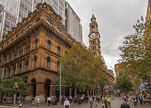
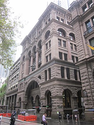
General Post Office, Sydney
Historic building in Sydney, Australia
Distance: Approx. 65 meters
Latitude and longitude: -33.867716,151.207699
The General Post Office (abbreviation GPO, commonly known as the Sydney GPO) is a heritage-listed landmark building located in Martin Place, Sydney, New South Wales, Australia. The original building was constructed in two stages beginning in 1866 and was designed under the guidance of Colonial Architect James Barnet. Composed primarily of local Sydney sandstone, mined in Pyrmont, the primary load-bearing northern façade has been described as "the finest example of the Victorian Italian Renaissance Style in NSW" and stretches 114 metres (374 ft) along Martin Place, making it one of the largest sandstone buildings in Sydney.

1999 Sydney hailstorm
Natural disaster in Australia
Distance: Approx. 79 meters
Latitude and longitude: -33.86722222,151.2075
The 1999 Sydney hailstorm was the costliest natural disaster in Australian insurance history, causing extensive damage along the east coast of New South Wales. The storm developed south of Sydney on the afternoon of Wednesday, 14 April 1999, and struck the city's eastern suburbs, including the central business district, later that evening. The storm dropped an estimated 500,000 tonnes of hailstones in its path.
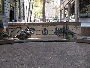
Regimental Square
War memorial in Sydney
Distance: Approx. 83 meters
Latitude and longitude: -33.86706389,151.20689167
Regimental Square is a war memorial in the Wynyard area in the city centre of Sydney, Australia. An upgrade of the area was expected to be completed by mid-2016.

341 George Street, Sydney
Heritage-listed building in Sydney, Australia
Distance: Approx. 67 meters
Latitude and longitude: -33.8673,151.2066
341 George Street, Sydney is a heritage-listed bank building located at 341 George Street, in the Sydney central business district, in the City of Sydney local government area of New South Wales, Australia. It was built from 1927 to 1932 and housed the headquarters of the Bank of New South Wales, and later Westpac. It is also known as Westpac Bank building and Bank of NSW building.
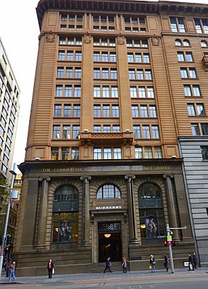
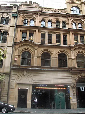
343 George Street, Sydney
Heritage-listed building in Sydney, Australia
Distance: Approx. 43 meters
Latitude and longitude: -33.8675,151.2067
343 George Street, Sydney is a heritage-listed former bank building and now nine-storey retail and commercial premises. It is located at 343 George Street in the Sydney central business district, in the City of Sydney local government area of New South Wales, Australia. It was built from 1921 to 1925, and until 2008 housed banking premises of the Commercial Banking Company of Sydney (CBC) and later National Australia Bank.
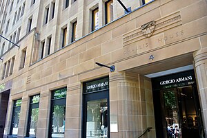
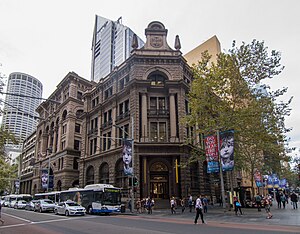
Challis House
Historic building in Sydney, Australia
Distance: Approx. 93 meters
Latitude and longitude: -33.8673,151.2078
Challis House is a heritage-listed commercial building located at 4–10 Martin Place in the Sydney central business district, in the City of Sydney local government area of New South Wales, Australia. The property was added to the New South Wales State Heritage Register on 2 April 1999.
22 York Street, Sydney
Heritage-listed building in Sydney, Australia
Distance: Approx. 86 meters
Latitude and longitude: -33.8682,151.2062
22 York Street, Sydney is a heritage-listed commercial office and former warehouse located at 22 York Street, in the Sydney central business district, in the City of Sydney local government area of New South Wales, Australia. It has now been incorporated into the Landmark Building development. The property is privately owned.
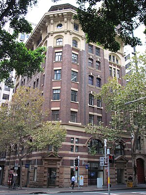
International House, Sydney
Historic site in New South Wales, Australia
Distance: Approx. 74 meters
Latitude and longitude: -33.8678,151.2062
International House is a heritage-listed commercial building at 14-16 York Street, in the Sydney central business district, in the City of Sydney local government area of New South Wales, Australia. It was designed by Robertson & Marks and built during 1913 by Howie, Brown & Moffat, Master Builders. It is also known as Pomeroy House.
348–352 George Street, Sydney
Heritage-listed building in Sydney, Australia
Distance: Approx. 107 meters
Latitude and longitude: -33.8669,151.2074
348–352 George Street, Sydney is a heritage-listed office building located at 348–352 George Street, in the Sydney central business district, in the City of Sydney local government area of New South Wales, Australia. It was designed by Edward Raht and built by Hudson and Loveridge. It is also known as the National Mutual Building (former), Society General Building, Societe Generale House, Equitable Building and 350 George Street, Sydney.
354 George Street, Sydney
Heritage-listed building in Sydney, Australia
Distance: Approx. 76 meters
Latitude and longitude: -33.8672,151.2074
354 George Street, Sydney is a heritage-listed retail and office building and former bank building located at 354 George Street, in the Sydney central business district, in the City of Sydney local government area of New South Wales, Australia. It was designed in various stages by Edward Raht, A. K. Henderson, Joseland & Gilling and Kevin Winterbottom and Assoc. and built in various stages from 1902 to 1937 by Loveridge & Hudson and Kell & Rigby.
Weather in this IP's area
clear sky
22 Celsius
21 Celsius
20 Celsius
23 Celsius
1019 hPa
59 %
10000 meters
2.06 m/s
40 degree
08:00:00
21:00:00
The latest IP detection test
- 144.4.118.199
- 174.212.194.243
- 53.11.98.192
- 176.192.214.100
- 170.17.227.127
- 177.118.83.147
- 196.86.42.189
- 122.217.123.27
- 94.49.64.33
- 210.18.41.30