Country:
 USA
USARegion:
City:
Latitude and Longitude:
Postal Code:
Time Zone:
language:
User-Agent:
Proxy IP:
Blacklist:
IP information under different IP Channel
ip-api
Country
IPinfo
Country
MaxMind
Country
Luminati
38.98.16.3Country
USRegion
ca
City
losangeles
ASN
Time Zone
America/Los_Angeles
ISP
PEER39-ASN
Latitude
Longitude
Postal
db-ip
Country
ipdata
Country
Popular places and events near this IP address

Chinatown, Los Angeles
Neighborhood of Los Angeles
Distance: Approx. 295 meters
Latitude and longitude: 34.062888,-118.23789
Chinatown is a neighborhood in Downtown Los Angeles, California, that became a commercial center for Chinese and other Asian businesses in Central Los Angeles in 1938. The area includes restaurants, shops, and art galleries, but also has a residential neighborhood with a low-income, aging population of about 7,800 residents. The original Chinatown developed in the late 19th century, and was demolished to make room for Union Station, the city's major ground-transportation center.
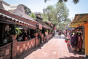
Olvera Street
Historic district in Los Angeles, United States
Distance: Approx. 390 meters
Latitude and longitude: 34.057495,-118.237996
Olvera Street, commonly known by its Spanish name Calle Olvera, is a historic pedestrian street in El Pueblo de Los Ángeles, the historic center of Los Angeles. The street is located off of the Plaza de Los Ángeles, the oldest plaza in California, which served as the center of the city life through the Spanish and Mexican eras into the early American era, following the Conquest of California. Restaurants, vendors, and public establishments line the street.

Philippe's
Restaurant in Los Angeles, California
Distance: Approx. 287 meters
Latitude and longitude: 34.059588,-118.236896
Philippe's, or "Philippe the Original" ( fi-LEEPS) is a restaurant located in downtown Los Angeles, California. The restaurant is well known for continuously operating since 1908, making it one of the oldest restaurants in Los Angeles. It is also renowned for claiming to be the inventor of the French dip sandwich.
Homeboy Industries
Nonprofit organization
Distance: Approx. 411 meters
Latitude and longitude: 34.06229722,-118.23567778
Homeboy Industries is a youth program founded in 1992 by Father Greg Boyle following the work of the Christian base communities at Dolores Mission Church in Boyle Heights, Los Angeles. The program is intended to assist high-risk youth, former gang members and the recently incarcerated with a variety of free programs, such as mental health counseling, legal services, tattoo removal, curriculum and education classes, work-readiness training, and employment services. A distinctive aspect of Homeboy Industries is its structure of a multifaceted social enterprise and social business.

Nuestra Señora Reina de los Ángeles Asistencia
Historical Catholic asistencia in Los Angeles, California
Distance: Approx. 390 meters
Latitude and longitude: 34.0572,-118.2396
Nuestra Señora Reina de los Ángeles Asistencia was founded in early 1784 in the burgeoning Pueblo de Los Ángeles adjacent to the village of Yaanga as an asistencia or "sub-mission" to the nearby Mission San Gabriel Arcángel. The assistant mission fell into disuse over time and a Catholic chapel, La Iglesia de Nuestra Señora Reina de los Ángeles, was constructed in its place a mere thirty years later.

Fort Moore Pioneer Memorial
Memorial in Los Angeles, California, U.S.
Distance: Approx. 335 meters
Latitude and longitude: 34.05833333,-118.24194444
The Fort Moore Pioneer Memorial is a large stone memorial wall built in 1957 on part of the original location of Fort Moore (named for Benjamin D. Moore) facing North Hill Street, in Los Angeles, California.
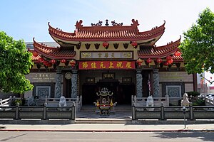
Thien Hau Temple (Los Angeles)
Distance: Approx. 231 meters
Latitude and longitude: 34.0626,-118.2407
The Thien Hau Temple is a Chinese temple located in Los Angeles's Chinatown in California, dedicated to the ocean goddess Mazu. It is one of the more popular areas for worship and tourism among Asian residents in the Los Angeles area. In addition to Mazu, the temple also venerates the martial deity of justice, Guan Sheng Di Jun (關聖帝君) and the wealth deity Fu De Zheng Shen (福德正神).
Broadway Tunnel (Los Angeles)
Former tunnel in Los Angeles, California
Distance: Approx. 360 meters
Latitude and longitude: 34.05805556,-118.24194444
The Broadway Tunnel was a tunnel under Fort Moore Hill in Downtown Los Angeles, California. It extended North Broadway (formerly Fort Street), at Sand Street (later California Street), one block north of Temple Street, northeast to the intersection of Bellevue Avenue (later Sunset Boulevard, now Cesar Chavez Avenue), to Buena Vista Street (now North Broadway).
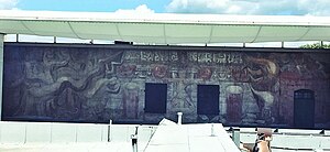
América Tropical: Oprimida y Destrozada por los Imperialismos
1932 mural by David Alfaro Siqueiros
Distance: Approx. 357 meters
Latitude and longitude: 34.05791667,-118.23777778
América Tropical is a 98-foot wide fresco mural created in 1932 by David Alfaro Siqueiros and other artists in Los Angeles, California, on a second-level exterior wall of the Italian Hall. It was painted over soon after its completion on an external wall of the Italian Hall on Olvera Street, in El Pueblo de Los Angeles Historical Monument of Downtown Los Angeles. It was restored and revealed to the public in 2012, 80 years to the day after its first unveiling.
Casa de Castelar
Settlement house in Los Angeles, California
Distance: Approx. 223 meters
Latitude and longitude: 34.0627,-118.2395
Casa de Castelar (later, The College Settlement) was an American settlement in Los Angeles, California. It was founded in February 1894, during the settlement movement era, by a local branch of the College Settlements Association called the Los Angeles Settlement Association (LASA). Casa de Castelar was the first settlement house in the city, and the first settlement house west of the Mississippi River.

Chinatown Gateway Monument
Gate in Los Angeles, California, U.S.
Distance: Approx. 198 meters
Latitude and longitude: 34.05894444,-118.24002778
The Chinatown Gateway Monument is installed in Chinatown, Los Angeles, in the U.S. state of California. The gateway is located at the south entrance to Chinatown on North Broadway, just north of Cesar Chavez Avenue, few blocks from Los Angeles City Hall. In 2020, Wilder Shaw of Thrillist described the gate as "infamous".
Bracero Monument
Monument in Los Angeles, California, U.S.
Distance: Approx. 272 meters
Latitude and longitude: 34.05827778,-118.24005556
The Bracero Monument by Dan Medina is installed in Los Angeles, California. The 19-foot-tall monument features a bronze sculpture of a Mexican migrant and his family (wife and son).
Weather in this IP's area
overcast clouds
14 Celsius
14 Celsius
13 Celsius
16 Celsius
1021 hPa
83 %
10000 meters
2.06 m/s
180 degree
100 %
23:00:00
18:00:00
The latest IP detection test
- 2.72.183.223
- 239.64.166.123
- 162.178.34.108
- 228.57.131.242
- 124.106.208.26
- 60.109.221.240
- 15.59.12.72
- 32.33.30.55
- 81.185.181.30
- 36.105.163.72