Country:
 Germany
Region:
City:
Latitude and Longitude:
Postal Code:
Time Zone:
language:
User-Agent:
Proxy IP:
Blacklist:
IP information under different IP Channel
Luminati
47.254.165.125Country
DERegion
he
City
frankfurtammain
ASN
Time Zone
Europe/Berlin
ISP
Alibaba US Technology Co., Ltd.
Latitude
Longitude
Postal
Popular places and events near this IP address
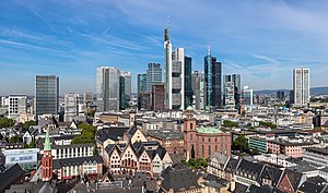
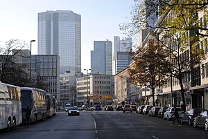
Frankfurt
Largest city in Hesse, Germany
Distance: Approx. 41 meters
Latitude and longitude: 50.11055556,8.68222222
Frankfurt am Main (German: [ˈfʁaŋkfʊʁt ʔam ˈmaɪn] ; lit. "Frank ford on the Main") is the most populous city in the German state of Hesse. Its 773,068 inhabitants as of 2022 make it the fifth-most populous city in Germany, and it is the only city in the country rated as an "alpha world city" according to GaWC. Located in the foreland of the Taunus on its namesake Main, it forms a continuous conurbation with the neighbouring city of Offenbach am Main and its urban area has a population of over 2.3 million.

St. Paul's Church, Frankfurt am Main
Church and national assembly hall in Germany
Distance: Approx. 87 meters
Latitude and longitude: 50.11111111,8.68083333
St Paul's Church (German: Paulskirche) is a former Protestant church in Frankfurt, Germany, used as a national assembly hall. Its important political symbolism dates back to 1848 when the Frankfurt Parliament convened there, the first publicly and freely-elected German legislative body.

Römer
City Hall of Frankfurt
Distance: Approx. 73 meters
Latitude and longitude: 50.11027778,8.68166667
The Römer (German surname, "Roman") is a medieval building in the Altstadt of Frankfurt am Main, Germany, and one of the city's most important landmarks. The Römer is located opposite the Old St. Nicholas Church and has been the city hall (Rathaus) of Frankfurt for over 600 years.

Frankfurter Kunstverein
Distance: Approx. 61 meters
Latitude and longitude: 50.1107,8.6828
The Frankfurter Kunstverein e. V. in Frankfurt am Main is a non-profit organisation dedicated to the promotion of contemporary art and culture. It is one of the oldest German art associations.

Schirn Kunsthalle Frankfurt
Art museum in Frankfurt, Germany
Distance: Approx. 134 meters
Latitude and longitude: 50.11027778,8.68361111
The Schirn Kunsthalle is a Kunsthalle in Frankfurt, Germany, located in the old city between the Römer and the Frankfurt Cathedral. The Schirn exhibits both modern and contemporary art. It is the main venue for temporary art exhibitions in Frankfurt.

Free City of Frankfurt
Former city-state of Germany
Distance: Approx. 71 meters
Latitude and longitude: 50.11027778,8.68222222
For almost five centuries, the German city of Frankfurt was a city-state within two major Germanic entities: The Holy Roman Empire as the Free Imperial City of Frankfurt (German: Freie Reichsstadt Frankfurt) (until 1806) The German Confederation as the Free City of Frankfurt (Freie Stadt Frankfurt) (1815–66) Frankfurt was a major city of the Holy Roman Empire, being the seat of imperial elections since 885 and the city for imperial coronations from 1562 (previously in Free Imperial City of Aachen) until 1792. Frankfurt was declared an Imperial Free City (Freie und Reichsstadt) in 1372, making the city an entity of Imperial immediacy, meaning immediately subordinate to the Holy Roman Emperor and not to a regional ruler or a local nobleman. Due to its imperial significance, Frankfurt survived mediatisation in 1803.

Römerberg (Frankfurt)
Public square in Frankfurt, Germany
Distance: Approx. 71 meters
Latitude and longitude: 50.11027778,8.68222222
Römerberg (also spelled as Roemerberg, lit. 'Roman Mountain') is a public space in Frankfurt, Germany. It is located in front of the Römer building complex, seat of the Frankfurt city administration since the 15th century. As the site of numerous imperial coronations, trade fairs and Christmas markets, the square is the historic heart of the medieval Altstadt (old town) and today a popular tourist destination.

Old St. Nicholas Church
Distance: Approx. 101 meters
Latitude and longitude: 50.11,8.68222222
The Old St. Nicholas Church (in German: Alte Nikolaikirche) in Frankfurt, Germany, is a medieval Lutheran church. It is located near the Römer city hall in Frankfurt's old town called Altstadt.

New Frankfurt Old Town
Quarter between Dom and Römer in Frankfurt, Germany
Distance: Approx. 82 meters
Latitude and longitude: 50.11109,8.68311
The New Frankfurt Old Town (also known as the Dom-Römer Quarter) is the centre of the old town of Frankfurt am Main, Germany, which was reconstructed from 2012 to 2018 as part of a major urban development project called the Dom-Römer Project (German: Dom-Römer-Projekt). The project redesigned and developed a 7,000 m2 (75,000 sq ft) property between Römerberg in the west and Domplatz in the east, delimited by Braubachstrasse in the north and the Schirn Kunsthalle in the south, in an effort to remake the old city centre, the Altstadt (old town), which was severely damaged during World War II, in the style of the pre-war architecture. Due to the heavy bombing of Frankfurt am Main in World War II, most of the city's old town was destroyed.

Paulsplatz
Public square in Frankfurt, Germany
Distance: Approx. 48 meters
Latitude and longitude: 50.1111,8.6814
Paulsplatz (St. Paul's Square) is a historic square in the heart of Frankfurt, Germany. St Paul's Church is located here, dominating the square.
Berliner Straße (Frankfurt am Main)
Thoroughfare in Frankfurt, Germany
Distance: Approx. 100 meters
Latitude and longitude: 50.1118,8.6821
Berliner Straße is a major street in the city centre of Frankfurt am Main. It was built after the Bombing of Frankfurt am Main in World War II along the route of the old Schnurgasse.

Salzhaus
Distance: Approx. 13 meters
Latitude and longitude: 50.1108,8.6819
The Salzhaus (English: Salt House) is a historic building in the German city Frankfurt am Main. It forms the northeastern part of the Frankfurt City Hall complex (Römer), on the Römerberg square in the centre of the Altstadt (old town). The Salzhaus was originally built around 1600.
Weather in this IP's area
clear sky
19 Celsius
19 Celsius
18 Celsius
20 Celsius
1021 hPa
59 %
10000 meters
3.6 m/s
50 degree
11:00:00
19:00:00