Country:
 USA
USARegion:
City:
Latitude and Longitude:
Postal Code:
Time Zone:
language:
User-Agent:
Proxy IP:
Blacklist:
IP information under different IP Channel
ip-api
Country
IPinfo
Country
MaxMind
Country
Luminati
56.117.72.54Country
USASN
Time Zone
America/Chicago
Latitude
Longitude
Postal
db-ip
Country
ipdata
Country
Popular places and events near this IP address

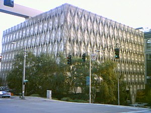
Columbia Center
Skyscraper in Seattle, US
Distance: Approx. 72 meters
Latitude and longitude: 47.60453,-122.33069
The Columbia Center, formerly named the Bank of America Tower and Columbia Seafirst Center, is a skyscraper in downtown Seattle, Washington, United States. The 76-story structure is the tallest building in the state of Washington, reaching a height of 933 ft (284 m). At the time of its completion, the Columbia Center was the tallest structure on the West Coast; as of 2017, it is the fourth-tallest, behind buildings in Los Angeles and San Francisco.
King County Administration Building
Distance: Approx. 141 meters
Latitude and longitude: 47.60305556,-122.32944444
The King County Administration Building is a nine-story office building in Seattle, the seat of King County, Washington, United States. Completed in 1971, the building is located at 500 Fourth Avenue, in between Jefferson Street and James Street, and parking is available in parking garages on all surrounding streets. Designed by the Harmon, Pray and Detrich architectural firm, it features a unique hexagonal, honeycomb theme in its walls and windows.

Seattle Municipal Tower
Skyscraper in downtown Seattle, Washington
Distance: Approx. 89 meters
Latitude and longitude: 47.6051,-122.3298
Seattle Municipal Tower is a skyscraper in downtown Seattle, Washington. At 220.07 m (722.0 ft), it is the fifth-tallest building in the city. Completed in 1990, it was initially named AT&T Gateway Tower and subsequently KeyBank Tower after its anchor tenants AT&T and KeyBank.

F5 Tower
660-foot-tall skyscraper in Downtown Seattle, Washington
Distance: Approx. 147 meters
Latitude and longitude: 47.60527778,-122.33111111
F5 Tower (previously The Mark and Fifth and Columbia Tower) is a 660-foot-tall (200 m) skyscraper in Downtown Seattle, Washington. It consists of 44 floors and is the sixth-tallest building in Seattle. The tower consists of 516,000 square feet (47,900 m2) of office space leased entirely by F5 Networks and a 189-room luxury hotel operated by Lotte Hotels & Resorts.

3rd & Cherry
Proposed 629-foot (192 m) tall, 57-story skyscraper in downtown Seattle, Washington
Distance: Approx. 145 meters
Latitude and longitude: 47.6034,-122.3312
3rd & Cherry, formerly Seattle Civic Square, is a planned 629-foot (192 m) tall, 57-story skyscraper in downtown Seattle, Washington, United States. The residential high-rise, located near Seattle City Hall and the Seattle Civic Center, will have 520 condominiums and amenity spaces, including a public plaza at ground level and retail spaces. It was originally proposed in 2007 but has been delayed due to political and financial issues, undergoing several redesigns under various developers.
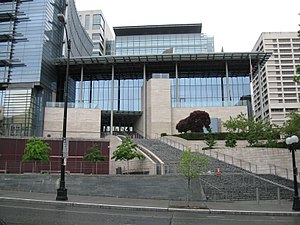
Seattle City Hall
Government offices in Washington, U.S.
Distance: Approx. 85 meters
Latitude and longitude: 47.605061,-122.32982
Seattle City Hall (also known as the Seattle Municipal Building) is the home of the offices of the mayor and city council of Seattle, Washington, located between 4th Avenue and 5th Avenue in the downtown area of the city. Most city departments have their offices in the nearby Seattle Municipal Tower. In 2003, the Seattle city government moved into a new, "green" city hall building.
Seattle Civic Center
Distance: Approx. 77 meters
Latitude and longitude: 47.60361111,-122.32972222
The Seattle Civic Center is a building complex in Seattle, Washington. The complex comprises several buildings owned by the City of Seattle and King County that cover several city blocks. The buildings include: King County Administration Building (1971) King County Correctional Facility King County Courthouse (1916) Seattle City Hall (2005) Seattle Justice Center (2002) Seattle Municipal Tower (1990) 400 Yesler Building (1909) The complex also contained the Public Safety Building until it was demolished in 2005.
4/C
Proposed supertall skyscraper in Seattle, Washington
Distance: Approx. 131 meters
Latitude and longitude: 47.6040184,-122.3314913
4/C, also known as 4th & Columbia, is a proposed supertall skyscraper in Seattle, Washington, United States. If built, the 1,020-foot-tall (310 m), 91-story tower would be the tallest in Seattle, surpassing the neighboring Columbia Center, and the first supertall in the Pacific Northwest. The project has been under development by Miami-based Crescent Heights since 2015 and undergone several design changes and modifications under three architecture firms.
Seattle Department of Transportation
Government agency in state Washington
Distance: Approx. 78 meters
Latitude and longitude: 47.605,-122.32972222
The Seattle Department of Transportation (SDOT) is a municipal government agency in Seattle, Washington that is responsible for the maintenance of the city's transportation systems, including roads, bridges, and public transportation. The agency is funded primarily by taxes that are supplemented by voter-approved levies from other sources; its budget in 2017 was $450 million.
Seattle Justice Center
Government office building and courthouse in Seattle, Washington, US
Distance: Approx. 50 meters
Latitude and longitude: 47.60416667,-122.32916667
The Seattle Justice Center is a 13-story government office building in Seattle, Washington, United States. It is located at 600 5th Avenue in the city's civic center complex and houses the Municipal Court of Seattle and the headquarters of the Seattle Police Department. The building was completed in 2002 at a cost of approximately $92 million, taking two years to construct.
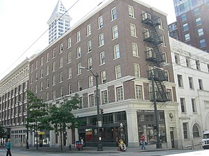
Rector Hotel
United States historic place
Distance: Approx. 133 meters
Latitude and longitude: 47.60333333,-122.33083333
The Rector Hotel, later known as the St. Charles Hotel and during the 1930s the Governor Hotel, is a historic hotel building located at the Southwest corner of Third Avenue and Cherry Street in downtown Seattle, Washington. It was constructed in the latter half of 1911 by the estate of pioneer lumber baron Amos Brown.
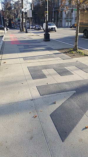
Black Lives Matter street mural (Seattle City Hall)
Mural in Seattle, Washington, U.S.
Distance: Approx. 100 meters
Latitude and longitude: 47.60347222,-122.33033333
A Black Lives Matter mural was painted outside Seattle City Hall, in the U.S. state of Washington, in 2021.
Weather in this IP's area
broken clouds
11 Celsius
10 Celsius
9 Celsius
13 Celsius
1025 hPa
77 %
10000 meters
3.13 m/s
3.58 m/s
268 degree
75 %
08:00:00
20:00:00
The latest IP detection test
- 234.23.84.244
- 229.181.86.116
- 140.51.242.220
- 37.75.241.178
- 43.13.149.45
- 80.65.250.82
- 171.73.203.188
- 47.103.134.193
- 223.76.123.15
- 108.131.54.51