Country:
 USA
USARegion:
City:
Latitude and Longitude:
Postal Code:
Time Zone:
language:
User-Agent:
Proxy IP:
Blacklist:
IP information under different IP Channel
ip-api
Country
IPinfo
Country
MaxMind
Country
Luminati
76.123.165.41Country
USRegion
ms
City
hattiesburg
ASN
Time Zone
America/Chicago
ISP
COMCAST-7922
Latitude
Longitude
Postal
db-ip
Country
ipdata
Country
Popular places and events near this IP address

Hattiesburg station
Distance: Approx. 371 meters
Latitude and longitude: 31.3272,-89.2864
Hattiesburg station, also known as Union Station and New Orleans & Northeastern Passenger Depot, is an Amtrak intercity train station located in Hattiesburg, Mississippi, at 308 Newman Street. The station is served by Amtrak's Crescent passenger train, and is the last regular stop before its southern terminus in New Orleans. On June 14, 2001, the depot was selected as a Mississippi Landmark (035-HAT-0088-NRD-ML), and in 2002, the depot was designated as a contributing resource within the Hub City Historic District (Boundary Increase) (Reference Number 02000855, listed 2002-08-09) on the National Register of Historic Places.

Sacred Heart Catholic School (Hattiesburg, Mississippi)
Private school in Hattiesburg, , Mississippi, United States
Distance: Approx. 606 meters
Latitude and longitude: 31.32277778,-89.29416667
Sacred Heart Catholic School (www.shshattiesburg.com) is a Roman Catholic parochial school in the historic district of downtown Hattiesburg, Mississippi where it is mostly surrounded by Victorian-era homes and other churches. It is the only PK-12 school in Northern Deanery of the Roman Catholic Diocese of Biloxi. Sacred Heart Catholic High School was officially detached from the elementary school on June 8, 2010 when the Hattiesburg City Council voted to accept a bid of $2.5 million for the city-owned property formerly known as First Baptist Church.
Forrest County School District
School district in Mississippi, United States
Distance: Approx. 263 meters
Latitude and longitude: 31.326962,-89.293061
The Forrest County School District is a public school district with its headquarters in Hattiesburg, Mississippi (USA) It serves sections of Forrest County, including portions of Hattiesburg, Glendale, and Rawls Springs. Brooklyn is the largest community in the district.
WQID-LP
Radio station in Hattiesburg, Mississippi
Distance: Approx. 31 meters
Latitude and longitude: 31.327,-89.29
WQID-LP (105.3 FM, "Hot 105.3") is a low-power FM radio station licensed to serve the community of Hattiesburg, Mississippi, and serving the Laurel-Hattiesburg area. The station airs an urban contemporary format.
WORV
Radio station in Hattiesburg, Mississippi
Distance: Approx. 1866 meters
Latitude and longitude: 31.3425,-89.29805556
WORV (1580 AM, "Heartbeat of the Hub City") is a radio station broadcasting a religious format. Licensed to Hattiesburg, Mississippi, United States, the station serves the Laurel-Hattiesburg area. The station is currently owned by Circuit Broadcasting Co.

Masonic Temple (Hattiesburg, Mississippi)
Historic building in Hattiesburg, Mississippi, United States
Distance: Approx. 154 meters
Latitude and longitude: 31.32761111,-89.29180556
The Masonic Temple in Hattiesburg, Mississippi, is a historic building that was designated a Mississippi Landmark in 2003. Originally constructed as a meeting hall for Hattiesburg Lodge 397, the building was sold when the lodge moved to a new location (on Eatonville Road). No Masonic lodges currently meet in the building.
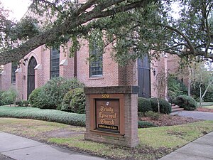
Trinity Episcopal Church (Hattiesburg, Mississippi)
Church in Mississippi, United States
Distance: Approx. 581 meters
Latitude and longitude: 31.323693,-89.294927
Trinity Episcopal Church is an historic church located at 509 West Pine Street in Hattiesburg, Mississippi, located in Forrest County. The church is in the Oaks Historic District which is listed on the National Register of Historic Places listings in Forrest County, Mississippi. It is a member of the Episcopal Diocese of Mississippi.
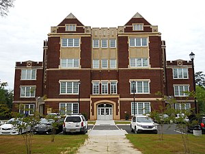
Old Hattiesburg High School
United States historic place
Distance: Approx. 565 meters
Latitude and longitude: 31.3294,-89.2956
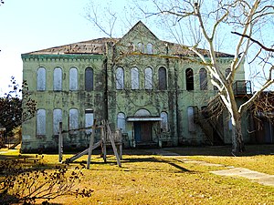
Old Hattiesburg High School, located at 846 North Main Street, in Hattiesburg, Mississippi, was utilized as a public school building from around 1911 to 1959. The building was designated a Mississippi Landmark in 1986 and was added to the National Register of Historic Places in 1987. In 2007, the structure was heavily damaged by arson.

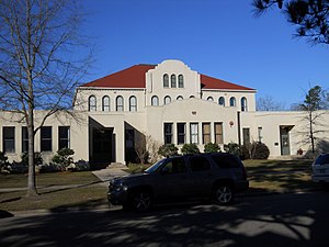
African American Military History Museum
United States historic place
Distance: Approx. 821 meters
Latitude and longitude: 31.33416667,-89.29277778
The African American Military History Museum, also known as East Sixth Street USO Building, located in Hattiesburg, Mississippi, United States, opened to the public on May 23, 2009. The museum building was originally constructed in 1942 as a USO Club for African American soldiers who were stationed at Camp Shelby. The structure was added to the National Register of Historic Places in 2004 and was designated a Mississippi Landmark in 2010.
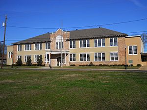
Eureka School (Hattiesburg, Mississippi)
Historic building in Hattiesburg, Mississippi, United States
Distance: Approx. 849 meters
Latitude and longitude: 31.3347,-89.2911
Eureka School, located at 412 East 6th Street in Hattiesburg, Mississippi, was constructed in 1921 as a public school for African Americans. The school was the first brick school building for black students to be built in Mississippi. The former school building, which now houses a civil rights museum, was designated a Mississippi Landmark in 2005.
Walthall School (Hattiesburg, Mississippi)
United States historic place
Distance: Approx. 950 meters
Latitude and longitude: 31.31878,-89.28808
Walthall School, also known as Court Street School, is located at 601 Court Street in Hattiesburg, Mississippi. It was utilized as a public school building from 1902 until 1987. The building is a contributing property to the Hattiesburg Historic Neighborhood District, which was placed on the National Register of Historic Places in 1980.
Eaton Elementary School (Hattiesburg, Mississippi)
United States historic place
Distance: Approx. 988 meters
Latitude and longitude: 31.323758,-89.280672
Eaton Elementary School, also known as Third Ward School, is located at 1105 McInnis Ave. in Hattiesburg, Mississippi, United States. It was utilized as a public school building from 1905 until the late 1980s.
Weather in this IP's area
clear sky
31 Celsius
32 Celsius
30 Celsius
32 Celsius
1012 hPa
45 %
10000 meters
1.54 m/s
120 degree
12:00:00
08:00:00
The latest IP detection test
- 46.201.103.180
- 31.193.251.136
- 162.13.130.187
- 171.128.215.52
- 18.214.88.131
- 31.54.210.92
- 113.29.105.137
- 17.234.216.137
- 123.201.166.162
- 170.120.122.152